
Nearly Three Weeks After One Major Storm, 6–12 Inches of Snow Still Covers Washington, Baltimore and the Shenandoah Valley While West Virginia Mountains Hold Over a Foot
MARYLAND — Nearly three weeks after a single significant winter storm swept through the Mid-Atlantic, much of the region is still blanketed in measurable snow — an unusual and impressive sight for mid-February outside of the higher elevations.
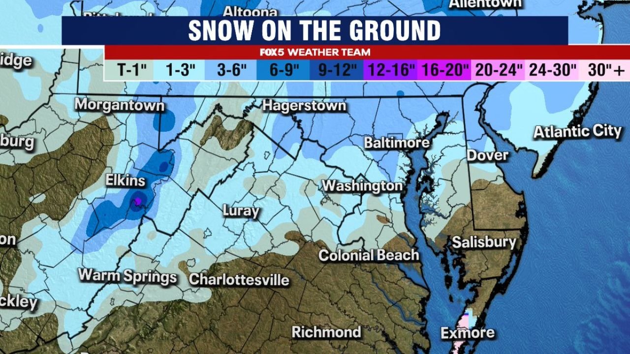
Current snow depth analysis shows that areas across western Maryland, northern Virginia, Washington D.C., and parts of Delaware and southern Pennsylvania continue to hold several inches of snow on the ground — most of it from a storm that occurred approximately 18 days ago.
6–12 Inches Still on the Ground in Parts of the Region
According to the latest snow depth map:
- Washington, D.C. and surrounding suburbs show several inches still present.
- Much of central and western Maryland, including near Hagerstown, remains in the 6–9 inch range in spots.
- Parts of northern Virginia around Luray and westward are also holding steady snow cover.
- Sections of southern Pennsylvania show persistent snow depth as well.
For an area that often sees quick snowmelt between systems, maintaining this level of snowpack nearly three weeks later is notable.
West Virginia Mountains Still Holding Over a Foot
The most significant remaining snowpack sits in the higher terrain of West Virginia, particularly near:
- Elkins
- Warm Springs
- Higher elevations along the Allegheny Front
In these mountainous zones, snow depths exceed 12 inches, with isolated pockets even higher.
Elevation plays a major role here, allowing colder temperatures to preserve the snowpack long after the original storm passed.
Coastal Areas Lighter but Still White
Toward the Chesapeake Bay and coastal regions:
- Baltimore and surrounding counties still show measurable snow cover.
- Parts of Delaware near Dover retain lighter accumulations.
- Snow cover tapers farther south toward Richmond, where much less remains.
While totals are lower closer to the coast, the persistence itself is noteworthy for this region.
Why This Is So Unusual
Outside of the mountains, most Mid-Atlantic snow events are followed by:
- Daytime melting
- Periods of rain
- Temperature swings above freezing
The fact that much of this snow cover originated from a single storm nearly three weeks ago highlights:
- Sustained colder-than-average temperatures
- Limited significant warm-ups
- Minimal heavy rain events to erode the snowpack
This kind of snow longevity is more typical of interior Northeast locations than the D.C.–Baltimore corridor.
What It Means Going Forward
With colder patterns still influencing the broader eastern U.S., any additional snowfall events would fall onto an existing base in some areas — particularly across western Maryland and West Virginia.
Even if warmer days occasionally occur, nighttime refreezing and limited strong thaw periods have allowed snow to remain entrenched.
For residents across Washington D.C., Baltimore, western Maryland, northern Virginia, and the West Virginia highlands, this winter has delivered a rare stretch of sustained snow cover.
Waldronnews.com will continue monitoring how long this snowpack persists and whether additional systems add to totals before winter loosens its grip on the Mid-Atlantic.