
Nebraska to New York Snow Surge? GFS Model Shows Heavy Snow Across Montana, Minnesota, Michigan and a Deep Freeze in Pennsylvania and New England Over Next 15 Days
UNITED STATES — The latest extended-range GFS model run is turning heads, painting a dramatic weather pattern for the next two weeks featuring widespread snowfall across the northern tier of the country and a sharp temperature divide between a frigid East and an unusually warm West.
Forecasters caution that long-range guidance can change, but the current setup suggests an active and volatile stretch to close out February and begin March.
Snow Blanket Stretching Coast to Coast Across the North
The 15-day total snowfall projection shows a broad swath of snow extending from the Pacific Northwest across the northern Rockies, through the Plains, into the Great Lakes and Northeast.
Highlighted regions include:
- Washington, Idaho, Montana, and Wyoming with significant mountain and valley accumulations
- North Dakota, South Dakota, Nebraska, and Minnesota under persistent snow signals
- Wisconsin, Michigan, and northern Illinois seeing repeated systems
- Upstate New York and northern New England with steady snowfall potential
The model suggests multiple waves of energy tracking along the northern jet stream, keeping the snow machine active across the Upper Midwest and interior Northeast.
Parts of the central Plains, including Nebraska, have already experienced rapid swings in weather. Reports indicate areas that recently enjoyed mild, golf-friendly temperatures quickly flipped to a 10-inch blizzard within a day — a sign of the volatile pattern in place.
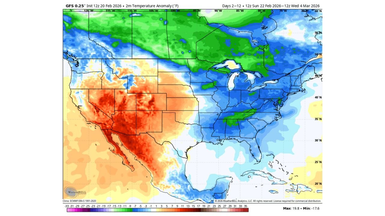
Bitter Cold Locking Into the Eastern U.S.
Temperature anomaly projections for the next 10 days show widespread below-normal readings across:
- The Midwest
- The Ohio Valley
- The Mid-Atlantic
- The Northeast
- Portions of the Southeast
Blues dominate the eastern half of the country on the anomaly map, indicating temperatures several degrees below seasonal averages.
Cold air draining south from Canada appears poised to reinforce storm systems and support continued snow chances across northern states.
Western U.S. Heating Up
In stark contrast, the western United States — particularly:
- California
- Nevada
- Arizona
- Utah
- New Mexico
- Portions of Colorado
— shows strong above-normal temperature anomalies. Deep oranges and reds dominate the Southwest, suggesting significantly warmer-than-average conditions.
This sharp ridge in the West combined with troughing in the East is helping to fuel the active storm track across the northern U.S.
What This Means Going Forward
If this pattern verifies:
- The northern tier could see repeated snowfall events through early March.
- Travel disruptions may periodically impact the Upper Midwest and Great Lakes.
- Energy demand could spike across the eastern half of the country.
- The Southwest may experience early hints of spring warmth.
While details will evolve, the overall signal is clear: winter is not backing down quietly.
Stay with Waldronnews.com for continued updates as we track how this dynamic late-winter pattern unfolds across the country.