
Negative WPO Pattern Signals Widespread December Cold Across Arkansas, Oklahoma, Missouri, and Tennessee, New Forecast Data Shows
UNITED STATES — A growing body of long-range climate data now points toward a significant and far-reaching December cold pattern expected to impact multiple central and southern states, including Arkansas, Oklahoma, Missouri, and Tennessee. Updated model guidance and analog comparisons highlight a strong shift into a deeply negative West Pacific Oscillation (WPO) — a pattern historically tied to widespread U.S. Arctic outbreaks.
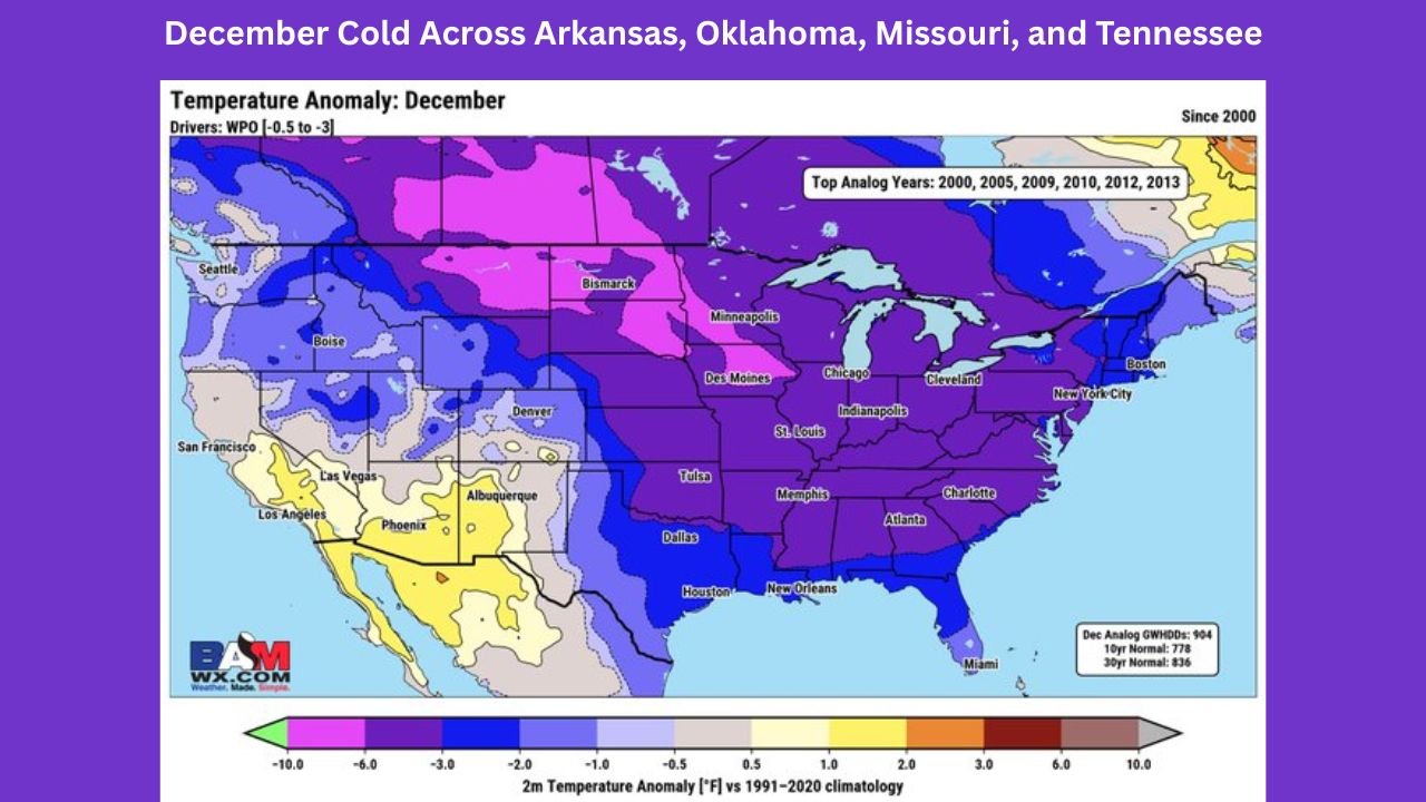
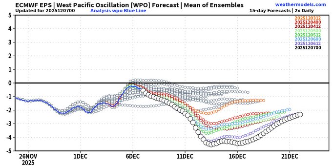
New ensemble projections released this week show the WPO plunging toward –3 or lower, indicating a stable high-latitude block capable of steering persistent cold air deep into the country.Understanding the Pattern: WPO Dips and Temperature Analogs
Meteorologists note that the WPO will sharply decline between December 6–16, with strong ensemble agreement. This shift aligns closely with analog years such as 2000, 2005, 2009, 2010, 2012, and 2013 — all of which produced extended cold spells across the central and eastern United States.
The December temperature anomaly map shows a broad region of purple and dark blue shading, meaning temperatures are projected to run well below the 30-year normal in several states.
Below is a state-by-state comparison of what this pattern means.
Arkansas: Widespread Below-Normal Temperatures Expected
Arkansas sits squarely within the deep negative anomaly zone, signaling a strong likelihood of:
- Extended cold outbreaks
- Multiple reinforcing Arctic fronts
- Limited daytime warm-ups during mid-month
Little in the current data suggests a meaningful warm period for Arkansas before late December.
Oklahoma: Early and Persistent Cold Signature
Oklahoma’s positioning on the western edge of the cold pool still places it in a zone that historically receives:
- Sharp temperature drops
- Wind-driven cold fronts
- Increased risk of bitter wind chills
Central and eastern Oklahoma appear colder than western areas, but the entire state trends below normal based on the analogs.
Missouri: Strongest Cold Signal in the Region
Missouri is among the states projected to experience the deepest cold anomalies in this pattern. Forecast indicators show:
- Some of the largest negative temperature departures in the Midwest
- A multi-day cold pattern with little interruption
- Strong support from analog years associated with early-season Arctic air
Missouri’s placement directly under the coldest shading suggests a strong possibility of prolonged subfreezing stretches.
Tennessee: Southern States Feeling the Arctic Push
Even though Tennessee sits farther south, the negative WPO pattern sends cold air sweeping into the Southeast, bringing:
- Well-below-normal temperatures for mid-December
- High potential for sharp morning lows
- Possible interactions with moisture that could bring winter precipitation risks later in the month
The state’s widespread purple shading indicates that Tennessee will not escape the broader regional cool-down.
Why This Matters: Confidence Is Increasing
Meteorologists emphasize a key point:
“The data will just keep flipping colder and trending colder until this changes.”
This means the cold pattern is not a one-off model run — multiple atmospheric signals are agreeing:
- The WPO crash is persistent.
- Ensemble spread is tight, showing high confidence.
- Analogs strongly support a cold December outcome.
Unless the pattern shifts unexpectedly, these four states should prepare for widespread, persistent cold from mid-December through the holiday period.
For continued updates on multi-state winter trends and how this evolving pattern could affect everyday life across the central and southern U.S., stay informed with WaldronNews.com — your trusted local source for accurate, clear, and timely weather coverage.