
New England Braces for Possible Icing as Tuesday–Wednesday System Tracks Along Boundary With Cold Air Locked In
UNITED STATES — The first notable weather disturbance of the upcoming week is set to arrive Tuesday night into Wednesday, and forecast data shows a classic setup for wintry precipitation — including potential icing — across parts of the Northeast, especially New England.
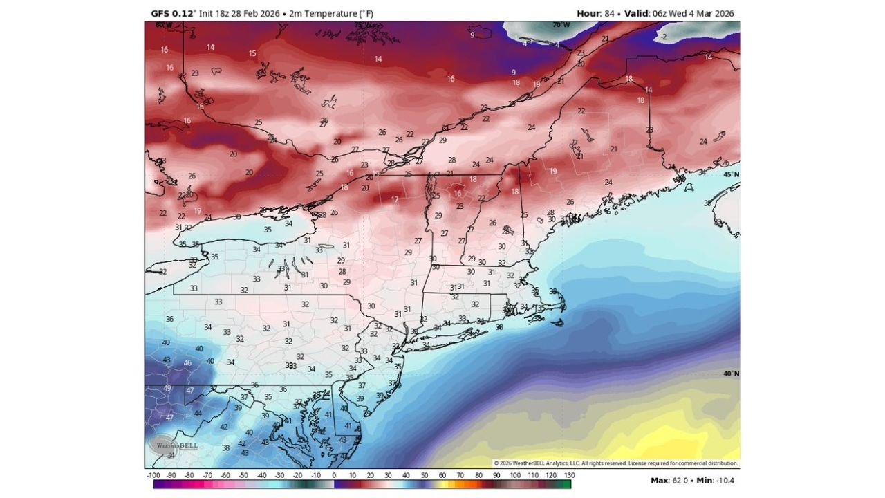
Model guidance valid around 06z Wednesday, March 4, 2026, indicates a weak but impactful wave of low pressure riding along a frontal boundary while cold air remains firmly entrenched over the interior Northeast.
Weak Wave, But Strong Temperature Contrast
The system is not particularly strong in terms of central pressure, but the atmospheric setup is what raises concern.
Key features from the forecast maps:
- A boundary draped from the Mid-Atlantic into southern New England
- Cold air locked in across interior New York, Vermont, New Hampshire, and Maine
- Warmer air surging northward just offshore and across southern coastal areas
This sharp temperature gradient creates the potential for multiple precipitation types across a relatively small geographic area.
Icing Risk Focused Across Interior New England
Precipitation-type guidance shows a corridor of mixed precipitation stretching from:
- Eastern Pennsylvania
- Northern New Jersey
- Southern New York
- Connecticut
- Rhode Island
- Much of Massachusetts
- Into southern New Hampshire
Pink shading on the map indicates sleet and freezing rain potential, particularly inland away from the immediate coast.
At the same time, surface temperature data shows many interior locations hovering between 24°F and 31°F during the event window — cold enough to support ice accretion if warm air overrides the shallow cold layer near the surface.
This is a classic “cold air damming” scenario, where dense, shallow cold air remains trapped at the surface while warmer air flows overhead.
Rain Along the Coast, Snow Farther North
Farther south and east — including portions of:
- Coastal New Jersey
- Long Island
- Cape Cod
- Coastal Rhode Island
Surface temperatures appear marginally above freezing, favoring plain rain.
Meanwhile, northern areas including:
- Upstate New York
- Northern Vermont
- Northern New Hampshire
- Interior Maine
Remain solidly below freezing with temperatures in the teens and low 20s, increasing the likelihood of snow or a snow/sleet mix.
Cold Air “Locked In” Over the North
One of the most important elements of this forecast is the persistence of cold air across New England and southeastern Canada.
The temperature map shows:
- Teens and low 20s across northern New England
- Single digits and teens across Quebec
- Below-freezing readings extending well south into interior New York and western Massachusetts
With that cold reservoir in place, even a weak disturbance can produce impactful icing if precipitation falls into sub-freezing surface air.
Why This Setup Can Be Sneaky
Though described as a “weak wave,” these boundary-riding systems often cause travel issues because:
- Precipitation is steady but not overly intense
- Surface temperatures hover right near freezing
- Small shifts in track can change precipitation type quickly
Even light freezing rain can create hazardous road conditions, especially during overnight or early morning hours.
Timing Window
The most likely period for precipitation appears to be:
- Late Tuesday evening into early Wednesday morning
By Wednesday afternoon, temperatures may begin moderating closer to the coast, but interior areas could remain icy longer if cold air is slow to retreat.
What This Means Going Forward
While not a major nor’easter, this first disturbance of note next week has the potential to produce localized icing problems across interior New England.
Residents from eastern Pennsylvania through Massachusetts and southern New Hampshire should monitor forecast updates closely, particularly if traveling during the Tuesday night–Wednesday morning window.
For continued analysis of this evolving Northeast setup and other developing systems across the country, stay connected with WaldronNews.com for the latest forecast updates and breakdowns.