
New England Snow Late Tonight Into Saturday Could Drop 3–6 Inches, With Local 8-Inch Stripe From Massachusetts Through Rhode Island and Connecticut
UNITED STATES — A fast-moving winter system is lining up to bring snow late tonight through Saturday, with the steadiest totals focused across parts of Massachusetts, Rhode Island, and Connecticut, plus eastern Long Island, New York. Forecast signals point to a colder, fluffier setup that can pile up quickly where the heaviest band sets up.
The current expectation: 3 to 6 inches for many, with localized totals near 8 inches possible in a corridor running roughly Boston (Massachusetts) → Providence (Rhode Island) → Hartford (Connecticut) → the Worcester/Boston area (Massachusetts), and also eastern Long Island (New York).
Why this setup favors “powdery” snow
Several ingredients in the data strongly support a light, dry, powdery snowfall rather than a wet, slushy event:
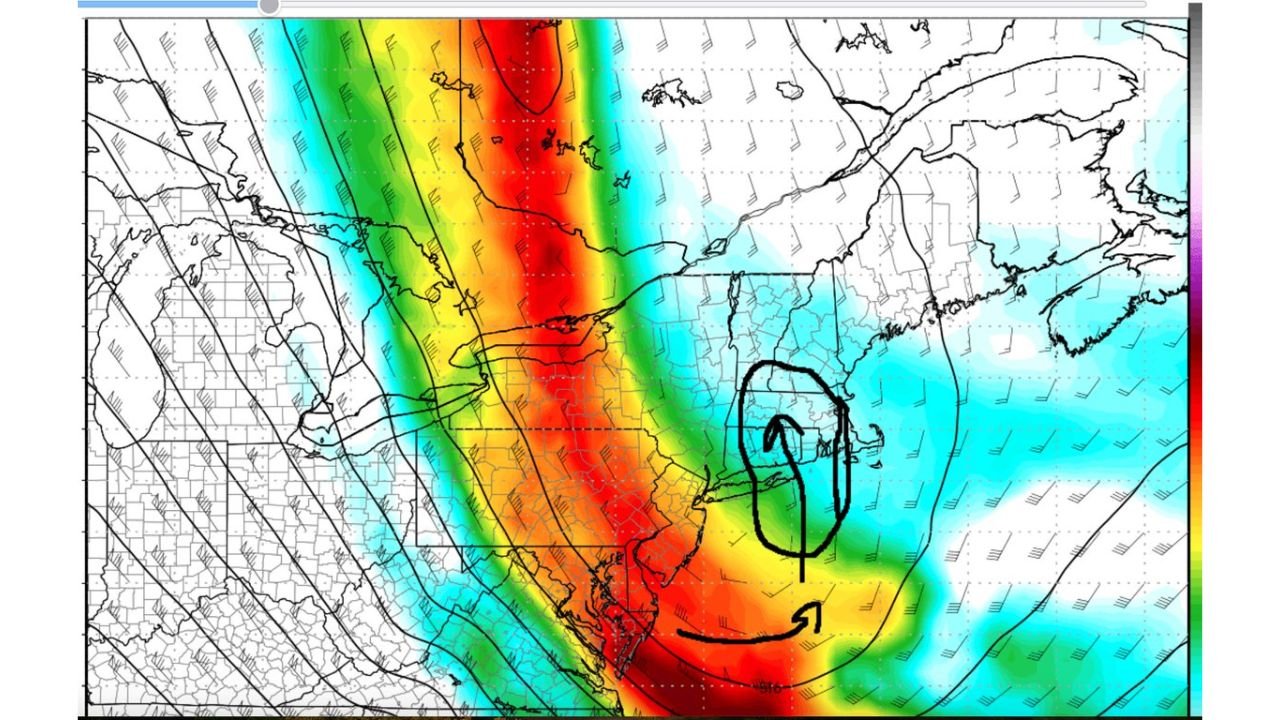
- Southerly flow at 500 mb combined with a negatively tilted trough suggests a more energized upper-level pattern that can enhance lift and banding.
- Cyclonic curvature at the surface signals a well-organized low-level circulation, which helps concentrate snowfall in a defined zone.
- Thickness values around 510–514 indicate a cold atmospheric column, a classic recipe for higher snow ratios (meaning the same amount of moisture can produce more inches of snow).
In plain terms: this isn’t just “it might snow.” It’s a setup where snow can accumulate fast—especially in any heavier bursts late tonight into early Saturday.
Where the heaviest snow band may set up
The data highlights a favored zone where totals could jump above the general 3–6 inch range.
Most likely higher-total corridor (localized 8 inches):
- Boston, Massachusetts (BOS)
- Providence, Rhode Island (PVD)
- Hartford, Connecticut (HFD)
- Worcester area, Massachusetts (ORH)
- Barnes/Westfield area, Massachusetts (BAF)
Additional area called out for impactful snow:
- Eastern Long Island, New York
Because this is a banded-style event, some towns can end up with several inches more than nearby communities, depending on where the most persistent snow sets up for a few hours.
Timing: late tonight into Saturday
This event is expected to be a late-night into daytime Saturday window, which often creates the toughest travel problems because:
- Roads may look fine early, then rapidly turn slick if a heavier burst moves in.
- Powdery snow can still cause reduced visibility, especially if winds pick up even modestly.
- A Saturday event still impacts airports, highways, and regional travel across southern New England and the NYC/Long Island region.
What impacts to plan for
Even a “moderate totals” snow can cause disproportionate disruption if it’s dry and falls efficiently.
Potential impacts include:
- Snow-covered roads and quick icing on untreated surfaces
- Slippery bridges and overpasses
- Lower visibility during heavier bursts
- Flight delays around major hubs in the Boston-to-New York corridor
If you’re in the Boston–Providence–Hartford lane or on eastern Long Island, the biggest concern is a few hours of steadier snow that pushes totals toward the high end.
What could change the totals
This kind of setup usually comes down to one main question:
Where does the heaviest snow band lock in—and for how long?
A shift of even 20–40 miles can mean the difference between:
- 3–4 inches, or
- 6–8 inches with a brief but intense period of snowfall.
That’s why it’s smart to plan for the higher-end scenario if you’re along the BOS–PVD–HFD zone.
Practical prep for tonight and Saturday morning
If you’re in Massachusetts, Rhode Island, Connecticut, or eastern Long Island, a few simple moves make a big difference:
- Charge devices and check flashlights (not because widespread outages are expected, but winter travel can create surprises)
- Allow extra travel time Saturday morning
- Keep salt/ice melt ready for stairs and walkways
- If you must drive, keep a winter kit: blanket, small shovel, gloves, and a phone charger
WaldronNews.com will continue tracking the band placement and snowfall corridor overnight—especially the Boston-to-Providence-to-Hartford stripe and eastern Long Island. What are conditions like where you live? Share what you’re seeing and keep following updates on WaldronNews.com.