
New England Winter Storm Threat Grows as Models Signal Heavy Snow From Washington, D.C. to Massachusetts Ahead of Patriots–Texans Game
NEW ENGLAND — Confidence is increasing that a developing East Coast winter storm will evolve into a significant snow event across New England from Sunday into early Monday, with growing indications that even the Patriots–Texans game could be impacted by snowfall. Multiple forecast models now show a colder, snowier setup, raising the odds of a true snow game as the storm strengthens offshore.
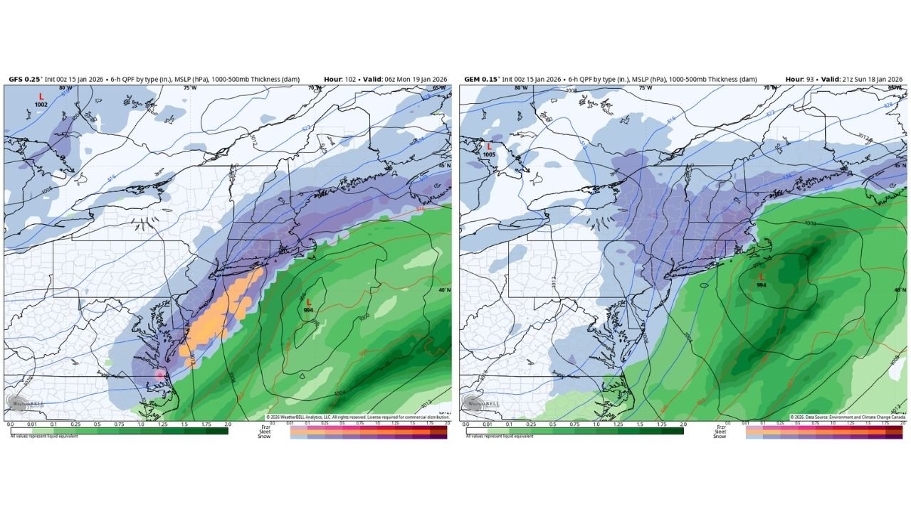
Recent overnight model runs show a clear trend toward heavier snow along the I-95 corridor, stretching from Washington, D.C., through Philadelphia, New York City, and into the Boston metro area. Forecasters note that both American and Canadian guidance are aligning more closely than earlier runs, increasing confidence that this system will deliver impactful winter weather rather than a mixed or rain-dominant outcome.
Forecast Models Show a Snowier Shift
The 00z GFS (Global Forecast System) and Canadian GEM models both depict a strengthening coastal low tracking northeastward just offshore. This path favors cold air remaining locked in over inland areas, allowing precipitation to fall primarily as snow for much of the Northeast.
Key model signals include:
- Expanding snow coverage across interior Mid-Atlantic and New England
- Heavier snow bands developing near and just inland from the coast
- Limited warm-air intrusion, reducing the risk of rain changing over snow
- Strong pressure gradients, suggesting gusty winds alongside snowfall
The Canadian model, in particular, shows a broader shield of accumulating snow, while the GFS highlights intense precipitation rates Sunday night into early Monday.
I-95 Corridor Faces Travel Impacts
If current trends hold, the I-95 corridor could experience hazardous travel conditions, especially during overnight and early-morning hours. Snowfall rates may become heavy at times, particularly across:
- Eastern Pennsylvania
- Northern New Jersey
- New York City and Long Island
- Southern and eastern New England
Urban areas that often struggle with marginal temperatures are now more likely to stay cold enough for snow, increasing the risk of road accumulations and delays.
Patriots–Texans Game Could Be Played in Snow
One of the most talked-about aspects of this storm is the growing chance that the New England Patriots vs. Houston Texans game takes place under falling snow. Model timing suggests snow could be ongoing or just beginning during game hours, creating classic winter football conditions.
While exact timing remains uncertain, the probability of:
- Light to moderate snow during kickoff
- Reduced visibility
- Cold, slick field conditions
has increased noticeably compared to earlier forecasts.
Storm Timing and What to Watch Next
Current projections place the onset of snow late Sunday, intensifying overnight before tapering off Monday morning as the system pulls away. Small changes in storm track will still matter, especially for coastal areas where rain/snow lines can shift.
Forecasters will be watching:
- Further model agreement on storm track
- Temperature trends near the coast
- Strength and placement of heavier snow bands
- Potential snowfall totals, which remain preliminary
Bottom Line
This storm is showing a clear colder and snowier trend, and confidence is rising that New England will see a meaningful winter weather event. While exact totals are still being refined, the overall setup strongly favors widespread snow and travel impacts, with the added intrigue of a possible snow-covered NFL game.
Residents across the Mid-Atlantic and Northeast should closely monitor updates as the forecast continues to sharpen over the next 24 to 48 hours.
What are your thoughts on this developing winter storm — and would you like to see a snow game in New England? Share your thoughts and stay updated with the latest weather developments by following Waldron News.