
New Jersey, Pennsylvania, and Delaware Face Weekend Snow Threat as Confidence Grows North and West of I-95
MOUNT HOLLY, NJ — Confidence is increasing that parts of New Jersey, eastern Pennsylvania, and northern Delaware will see accumulating snow on Saturday, especially north and west of the I-95 corridor, according to the latest forecast data. While Saturday snow potential is becoming clearer, forecasters stress that snowfall totals for Sunday remain highly uncertain.
Weather data from the National Weather Service shows winter weather advisories already in place for portions of northern New Jersey, with additional areas under close monitoring as colder air settles in.
Where Snow Is Most Likely This Weekend
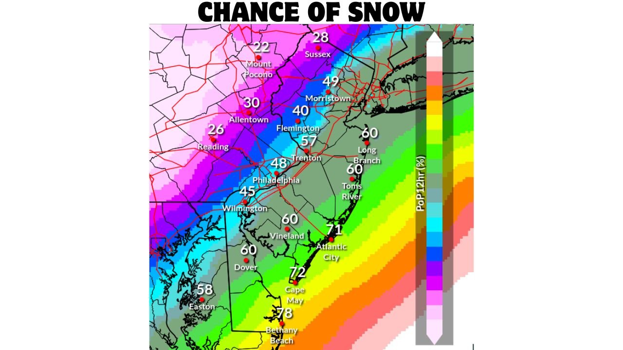
The highest confidence for snowfall continues to focus on inland locations away from the coast, where colder air will be firmly in place.
Areas with the greatest snow potential include:
- Northern and western New Jersey, including Sussex, Morris, and nearby counties
- Eastern Pennsylvania, especially near the Poconos, Allentown, and Reading
- Northern Delaware and far northern Maryland, mainly inland locations
Coastal areas closer to the Atlantic are more likely to see rain or a rain/snow mix, limiting accumulation.
Expected Snow Amounts on Saturday
Based on the latest snowfall projections:
- 2 to 4 inches possible across northern New Jersey and eastern Pennsylvania
- 1 to 2 inches likely closer to the I-95 corridor, including parts of Trenton and Philadelphia
- Minimal to no accumulation along the immediate New Jersey and Delaware coastlines
Snow is expected to develop Saturday morning and continue into the afternoon, with road impacts most likely during the daytime and early evening hours.
Winter Weather Advisories Issued
A Winter Weather Advisory is already in effect for parts of northern New Jersey, signaling increased confidence in travel impacts.
These advisories highlight:
- Snow-covered roads
- Reduced visibility
- Hazardous travel conditions, especially on untreated roads
Additional advisories could be expanded if confidence continues to grow.
What About Sunday? Confidence Drops Sharply
While Saturday’s forecast is coming into better focus, Sunday remains far less certain.
Forecast models currently show:
- Low confidence in storm track
- Highly variable snow chances, especially east of I-95
- A sharp gradient between snow inland and rain near the coast
Some inland areas may see additional light snow, but forecasters caution against locking in totals this far out.
Cold Air Will Follow Regardless of Snow
Even if snowfall remains limited in some areas, very cold air is expected to dominate early next week.
High confidence forecast highlights:
- Much colder temperatures Monday through Wednesday
- Wind chills dropping sharply, especially during the mornings
- Below-normal temperatures across New Jersey, Pennsylvania, and Delaware
Cold conditions could worsen any leftover snow or ice issues.
What Residents Should Do Now
With confidence increasing for at least some winter impacts, residents are encouraged to:
- Monitor updated forecasts daily
- Prepare for slower travel Saturday
- Have alternate weekend plans ready, especially for inland travel
- Allow extra time on roads, even for lighter snowfall totals
Waldron Weather Update
Weather conditions can change quickly. Stay with Waldron News for real-time updates, advisory changes, and localized impact forecasts as this winter system continues to evolve. Share this update with anyone traveling across New Jersey, Pennsylvania, or Delaware this weekend.