
New York City Could Plunge to -7°F Next Tuesday, Potentially Shattering March Cold Record as Polar Vortex Surge Targets New York and Northeast
NEW YORK — A powerful late-season Arctic blast could send temperatures in New York City, New York plummeting to levels rarely seen in March, with one major forecast model projecting a shocking -7°F low next Tuesday at Central Park.
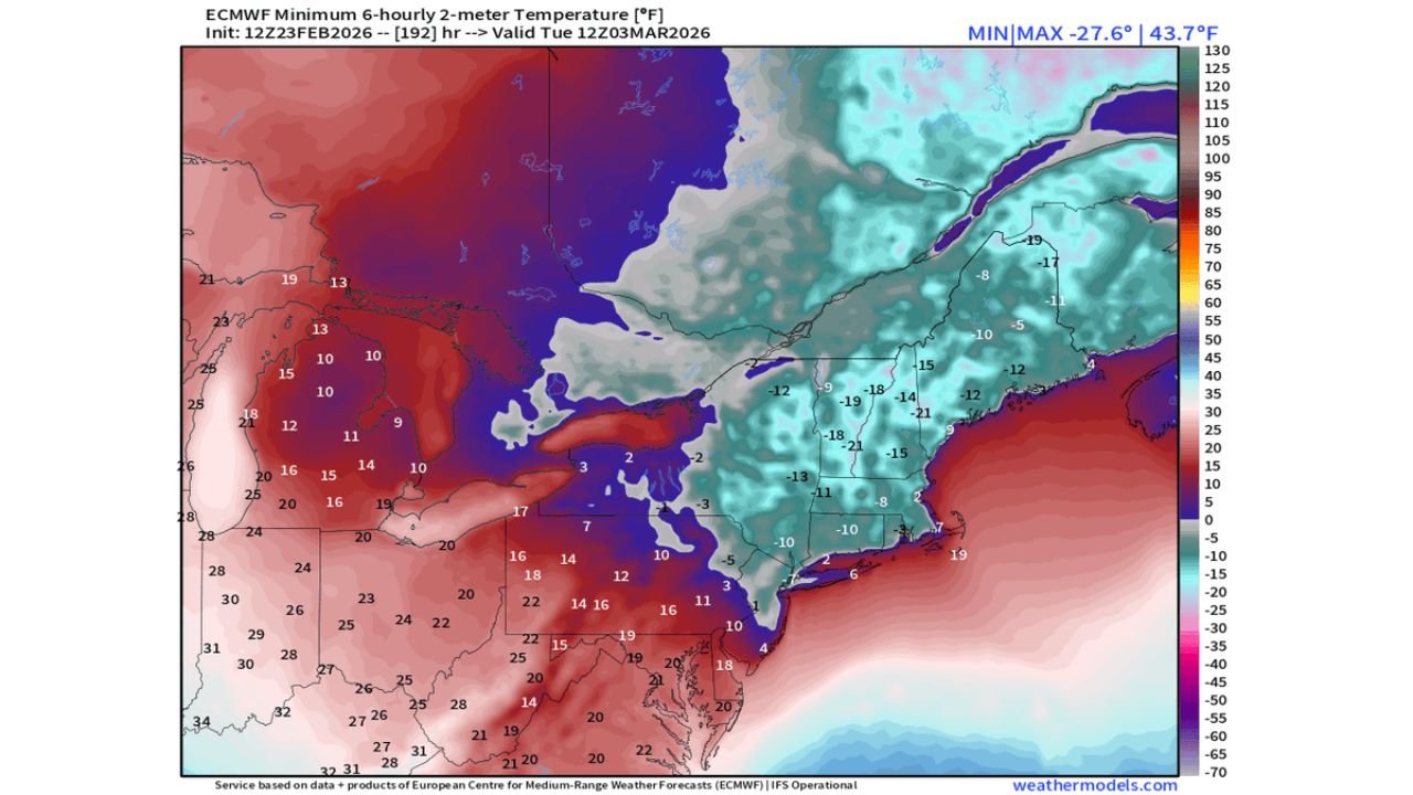
According to the latest ECMWF (European) operational model, the bitter cold would arrive around March 3, 2026, potentially making it not only the coldest day of this winter for NYC — but also the coldest temperature recorded so late in the season.
If that -7°F reading verifies, it would set a March record and likely rank as the coldest temperature recorded in New York City after February 15 in modern records.
ECMWF Model: -7°F for NYC Central Park
The ECMWF high-resolution forecast for KNYC (Central Park, NY) shows:
- High: 18°F
- Low: -7°F on Tuesday (March 3)
The ensemble prediction system (EPS) median is less extreme but still brutally cold, showing a projected low around 6°F.
Even the more moderate ensemble guidance would represent an exceptionally cold early March morning for the city.
Arctic Core Dropping Through the Northeast
Temperature maps valid for Tuesday show a deep Arctic air mass plunging across:
- Upstate New York
- Pennsylvania
- New Jersey
- Connecticut
- Massachusetts
- New Hampshire
- Vermont
- Maine
Forecast minimum temperatures across interior parts of New York State and New England fall into the negative teens and even lower.
Widespread lows shown in the ECMWF output include:
- -15°F to -20°F across northern New York and interior New England
- Single digits and sub-zero readings across much of Pennsylvania and New Jersey
- Near or below zero extending south toward parts of northern Maryland
The cold air mass appears expansive and deeply entrenched across the Northeast.
“Final Boss” Polar Vortex Surge
Meteorologists attribute the potential deep freeze to a late-season surge of the polar vortex — described as a “final boss” type Arctic outbreak — currently positioned near Greenland and funneling southward by way of Alaska before diving into the eastern United States.
This setup allows a direct pipeline of Arctic air to flood into the Northeast, bypassing moderating influences from the Atlantic.
The result: compressional warming stays offshore, while inland areas experience the full force of the cold dome.
Would -7°F Break Records?
If Central Park hits -7°F in early March:
- It would likely set a record for the coldest March temperature.
- It would rank among the coldest late-season readings in NYC history.
- It would potentially be the coldest temperature recorded after mid-February.
For perspective, typical early March lows in New York City are in the upper 20s to low 30s.
A -7°F reading would be more typical of mid-winter Arctic outbreaks in January — not the doorstep of spring.
Quick Rebound Expected
Interestingly, model guidance shows temperatures rebounding quickly after the Arctic surge.
By later in the forecast period:
- Highs climb back into the 40s
- Then into the 50s
- Potentially reaching the 60s by the second week of March
This dramatic temperature swing underscores the volatile nature of transitional-season weather patterns.
Still Several Days Away
While the ECMWF operational model is showing the most extreme scenario, ensemble guidance is somewhat less aggressive — though still strongly supportive of a significant cold outbreak.
As always with long-range Arctic forecasts, exact temperatures can shift depending on:
- Snow cover
- Wind speeds
- Timing of the coldest air
- Urban heat island effects in New York City
Still, confidence is increasing that New York, New Jersey, Connecticut, and much of the Northeast could experience one final and potentially historic Arctic punch next week.
WaldronNews.com will continue monitoring updated model runs as this late-season polar vortex surge approaches the eastern United States.