
New York, Connecticut, and New Jersey Snowfall Forecast Shows Widespread Accumulating Snow From Friday Night Into Saturday
NEW YORK — A developing winter weather system is expected to bring widespread accumulating snowfall across parts of New York, Connecticut, and New Jersey from late Friday into Saturday morning, according to the latest official forecast from the National Weather Service.
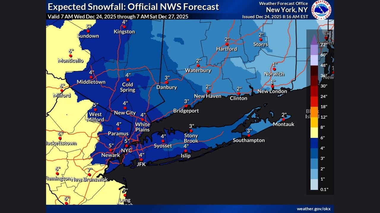
Updated snowfall maps indicate a broad swath of 2 to 5 inches of snow across much of the region, with locally higher totals possible in portions of the Hudson Valley, interior Connecticut, northern New Jersey, and Long Island.
Snow Begins Late Friday, Continues Into Early Saturday
Forecast guidance shows snow developing Friday evening, spreading steadily across the region overnight before tapering off Saturday morning.
Temperatures are expected to remain cold enough for snow to accumulate, especially away from immediate coastal areas. While snowfall rates are not expected to be extreme, the duration of the event supports measurable totals across multiple states.
Expected Snowfall Totals by Region
Based on the National Weather Service forecast:
- New York City Metro Area:
Most locations expected to see around 3 to 5 inches, including NYC, Westchester County, and Long Island. - Northern New Jersey:
Snow totals generally ranging from 4 to 6 inches, with locally higher amounts possible west and north of Newark. - Connecticut:
Coastal areas may see 1 to 3 inches, while interior locations such as Waterbury, Hartford, and Danbury could receive 2 to 4 inches, with isolated higher totals.
Snowfall amounts may vary sharply over short distances due to temperature differences and band placement.
Travel Impacts Likely Overnight and Early Saturday
The timing of the snow could create slick road conditions late Friday night and during the early Saturday morning travel period.
Drivers are urged to use caution, particularly on untreated roads, bridges, and overpasses. While this storm is not expected to be crippling, even modest snowfall combined with cold pavement temperatures can lead to hazardous driving conditions.
Forecast Could Still Shift Slightly
Forecasters note that snowfall totals may still be adjusted slightly as the system approaches. Small changes in temperature profiles or storm track could lead to localized increases or decreases in snow accumulation.
Residents across New York, Connecticut, and New Jersey are encouraged to monitor official National Weather Service updates as the event draws closer.
Stay Informed With WaldronNews.com
Weather conditions can change quickly. For continued updates on this winter weather system and other developing forecasts, follow WaldronNews.com for timely, accurate coverage.