
New York, Massachusetts, Vermont, and New Hampshire Brace for 18–24 Inches of Snow as Intense Blizzard Persists Across Eastern NY and Western New England
EASTERN UNITED STATES — A powerful winter storm continues to hammer eastern New York and western New England, with New York, Massachusetts, Vermont, and New Hampshire facing dangerous blizzard conditions, extreme snowfall rates, and major travel disruptions as the system shows no meaningful weakening.
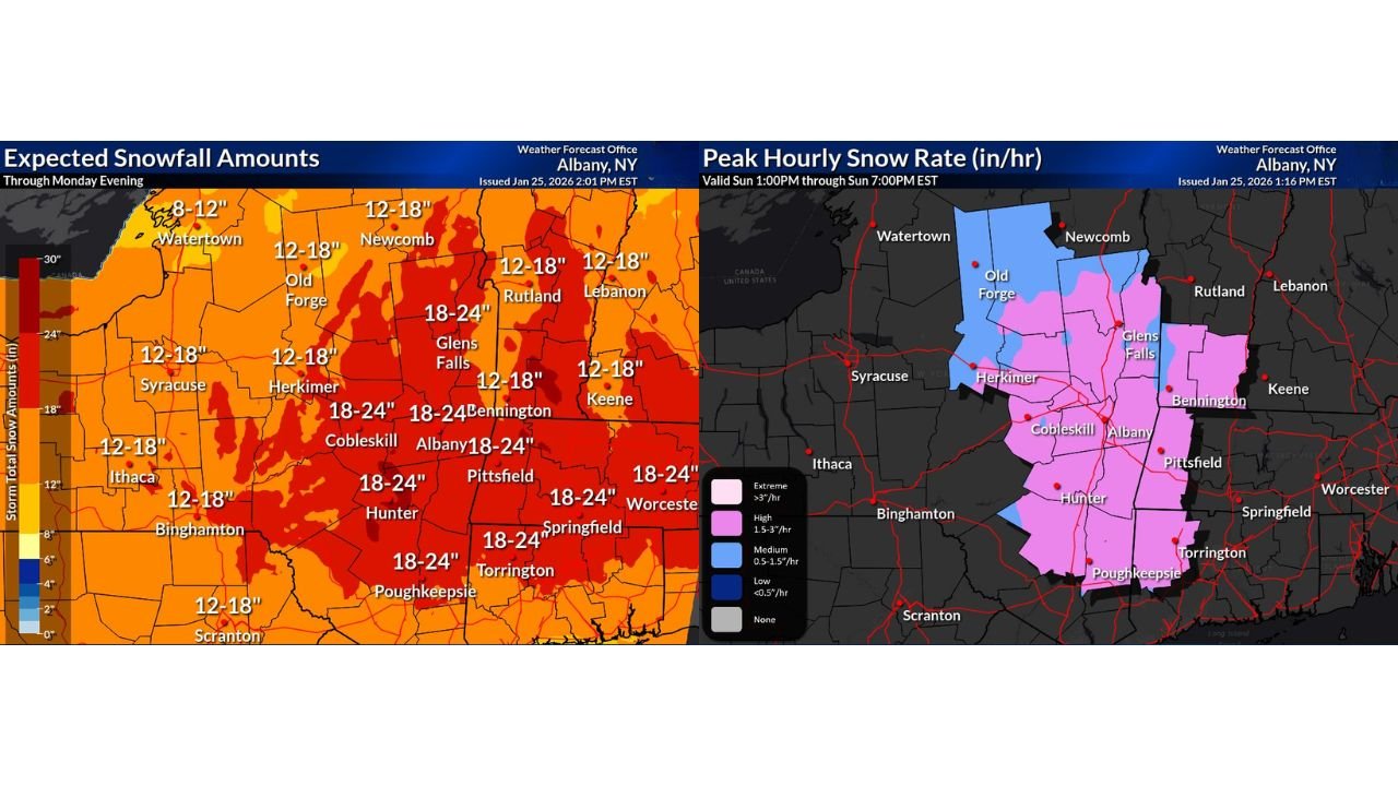
Latest forecast updates show no significant changes to expected snow totals, with widespread accumulations of 18 to 24 inches still on track across the hardest-hit corridor stretching from the Catskills and Capital Region of New York into western Massachusetts, southern Vermont, and southern New Hampshire.
Snowfall Totals Remain Locked In at 18–24 Inches
Updated storm-total snowfall maps confirm that much of eastern New York and western New England remains firmly within the 18–24 inch zone, with locally higher amounts possible in terrain-enhanced areas.
Areas most at risk for the highest totals include:
- Eastern and Central New York: Albany, Cobleskill, Glens Falls, Hunter, Poughkeepsie
- Western Massachusetts: Pittsfield, Springfield, surrounding Berkshires
- Southern Vermont: Bennington region
- Southern New Hampshire: Higher terrain near the VT border
Surrounding regions, including central New York, northeastern Pennsylvania, and parts of interior New England, are still expecting 12–18 inches, which is more than enough to create severe travel and infrastructure problems.
Snowfall Rates to Peak at 1.5–3 Inches Per Hour
Meteorologists warn that snowfall rates will intensify through the evening, with 1.5 to 3 inches per hour expected across the core impact zone.
These extreme rates mean:
- Roads may become impassable within minutes
- Plow crews will struggle to keep up
- Visibility may drop to near zero during heavier bursts
- Emergency response times could be significantly delayed
The most intense snowfall is expected Sunday evening, before rates slowly taper overnight — though lighter snow will continue into Monday.
Cleanup Will Be Slow and Difficult
With 11–13 inches already on the ground in some areas, additional overnight snow will make cleanup especially challenging. Cold temperatures will keep snow dry, powdery, and difficult to compact, while wind will continue to cause blowing and drifting.
Officials stress that:
- Snow removal will take much longer than usual
- Side roads may remain snow-covered well into Monday
- Residents should avoid unnecessary travel
What Happens Next: Back-End Snow Still a Wildcard
Forecasters are also monitoring a back-end ocean-effect snow component that could develop after the main storm passes. While models differ on placement and intensity, another 3–6 inches is possible in parts of eastern New England if conditions align.
Final snow totals may not be fully known until late Monday evening, especially in coastal-influenced and higher-elevation areas.
Bottom Line
This is a high-impact, long-duration winter storm for New York, Massachusetts, Vermont, and New Hampshire, with life-disrupting snowfall, dangerous travel, and slow recovery expected through at least Monday.
Residents should stay indoors when possible, prepare for extended cleanup, and monitor local advisories closely as conditions evolve.
Stay with WaldronNews.com for continuous updates, local impact reports, and the latest storm developments. What are conditions like where you live? Share your photos and updates in the comments.