
New York, New England, Pennsylvania, and New Jersey Could Face an Even Colder Arctic Blast Next Weekend After Brief Midweek Moderation
UNITED STATES — A brief period of moderating temperatures and gradual snowmelt is expected across the Northeast this week, but long-range forecast data suggests another potentially stronger surge of Arctic air may arrive next weekend, bringing colder conditions than the current outbreak across parts of New York, New England, Pennsylvania, and New Jersey.
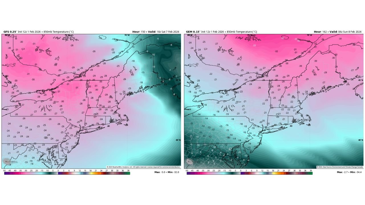
Upper-air temperature projections show a renewed and deeper cold pool developing over the northeastern United States, raising concerns that the region could experience its coldest air mass of the winter season so far.
Midweek Moderation Offers Only Temporary Relief
Model guidance indicates that temperatures will ease somewhat during the middle of the week, allowing some melting of recent snowfall across much of the Northeast. This brief moderation follows several consecutive nights of well-below-average cold.
However, the moderation appears short-lived, as larger-scale atmospheric patterns favor a fresh injection of Arctic air by next weekend.
Upper-Level Data Signals Stronger Cold Potential
Forecast maps showing 850-millibar temperatures — a key indicator of air mass strength — depict widespread values near or below –25°C to –30°C across large portions of the Northeast during the next weekend period.
These values are colder than those associated with the current cold spell and suggest the potential for more intense surface cold, particularly overnight and during any clear periods.
The coldest upper-level air is shown extending across:
- Upstate New York and interior New England
- Northern Pennsylvania
- Interior New Jersey
- Parts of Massachusetts, Vermont, New Hampshire, and Maine
Coastal Areas Also Affected, Though Slightly Moderated
While coastal areas of the Northeast typically avoid the most extreme cold due to ocean influence, forecast data still shows significant cold reaching the I-95 corridor, including portions of New York City, coastal New Jersey, and southern New England.
Even with some moderation near the coast, temperatures would remain well below seasonal averages if this air mass verifies.
Making Up for Lost Cold in Recent Winters
Meteorologists note that this winter has already featured more frequent and sustained cold episodes compared to several recent winters. The potential late-season Arctic surge could further reinforce that trend, effectively concentrating multiple years’ worth of missed cold into a single season.
If the projected pattern holds, next weekend’s cold could rival or exceed the severity of the current outbreak in terms of air mass intensity, even if snowfall is not involved.
Forecast Confidence Still Evolving
While confidence is increasing in another cold surge, forecasters caution that timing and exact intensity remain subject to change, especially at longer lead times. Even small shifts in the upper-level pattern could affect how deeply the cold penetrates into the region.
Residents across the Northeast are encouraged to stay aware of updated forecasts as the week progresses.
Stay with Waldronnews.com for continued updates on developing Arctic air, temperature trends, and late-winter weather risks across the United States.