
New York, Pennsylvania, and Ohio Face High Risk of 6+ Inches of Heavy Lake-Effect Snow as Models Show Intensifying Bands Through Thursday Night
UNITED STATES — A powerful lake-effect snow event is expected to intensify late Wednesday night through early Thursday, bringing a high probability of more than six inches of snow to several Great Lakes communities. New ensemble data shows a concentrated corridor of heavy snowfall forming downwind of Lakes Erie and Ontario, with Buffalo, Erie, Cleveland, and Syracuse emerging as the highest-impact zones.
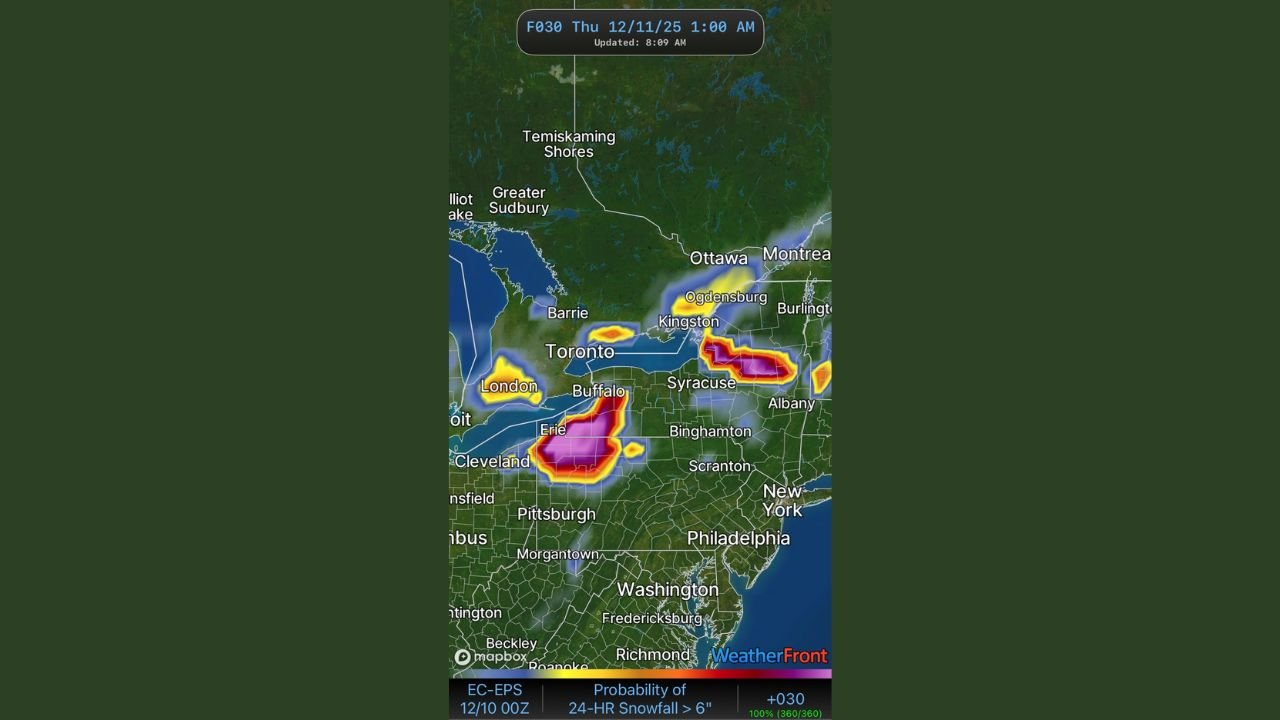
Strong Ensemble Agreement Shows Significant Snowfall Threat
New probabilistic data from the EC-EPS model suite reveals a sharp and well-defined snow axis stretching from northeastern Ohio into western and central New York. The updated forecast imagery shows widespread 80–100% probabilities for at least 6 inches of accumulation around Buffalo and Erie, where persistent lake-effect bands are expected to lock in and produce rapid snowfall rates.
Another high-probability zone is developing east of Lake Ontario, where the band could bring heavy snow to areas including Syracuse, Watertown, and the Tug Hill region. These regions are historically susceptible to intense lake-effect bursts when cold air crosses relatively warm lake waters—conditions that are firmly in place for this event.
Key Cities at Highest Risk
Forecast data indicates concentrated snowfall potential over:
- Buffalo, NY – Very high probability of exceeding 6 inches
- Erie, PA – Strong signal for heavy banding and intense snowfall rates
- Cleveland, OH – Western edge of the developing band with locally heavy totals
- Syracuse, NY – Enhanced probabilities tied to Lake Ontario plume
- Albany region – Lower but notable probabilities as bands shift east
These zones may experience localized higher totals, especially where the heaviest snow bands remain stationary for several hours.
Why This Event Is Taking Shape
A surge of colder air crossing the Great Lakes is creating an environment primed for lake-effect snow development. As the Arctic air mass interacts with the warm lake surfaces, vigorous upward motion fuels narrow but powerful snow bands capable of producing:
- Snowfall rates of 1–3 inches per hour
- Rapid visibility drops
- Quick accumulation on roadways
- Hazardous travel conditions, especially overnight
Model guidance from WeatherFront’s expanded suite—including HRRR, RRFS, ECMWF-AI, GEFS, and NBM—continues to show strong agreement, adding confidence to the snow expectations despite the sharply localized nature of lake-effect events.
Travel Impacts Expected to Be Significant
The overnight timing and intensity of the bands will likely disrupt highway travel on:
- I-90 through Buffalo, Erie, and Cleveland
- I-86 and Route 219 in western New York
- I-81 north of Syracuse
Short-range models indicate the most difficult conditions will occur where bands repeatedly track across the same areas, creating deep snow cover in just a few hours.
More Updates Coming as Bands Shift
Because lake-effect snow behaves differently from large-scale winter storms, band placement can shift quickly. Small changes in wind direction may move the heaviest snow miles away from previous tracks. Meteorologists will continue monitoring updates to determine whether the most intense bands strengthen further or drift into new regions.
WaldronNews.com will continue tracking this evolving situation and will provide updates as new model runs become available.
Stay safe, stay aware, and continue following WaldronNews.com for the latest weather developments across the Great Lakes region.