
New York, Pennsylvania, Massachusetts Brace for Arctic Wind Chills and Growing Winter Storm Threat Heading Into Mid-February
NORTHEASTERN UNITED STATES — A powerful stretch of winter weather is tightening its grip on the Northeast, with dangerous Arctic wind chills already impacting New York, Pennsylvania, and New England, while forecast models increasingly signal a higher-confidence winter storm threat for mid-February, potentially centered around February 14–16.
Meteorologists tracking the evolving pattern say winter is far from over — and may, in fact, be entering its most volatile phase yet.
Life-Threatening Wind Chills Grip New York and New England
The immediate concern remains the brutal Arctic air mass spilling into the region. Forecast guidance shows wind chills plunging to -30°F to -40°F across large parts of upstate New York, northern Pennsylvania, Vermont, New Hampshire, and western Massachusetts through the weekend.
Higher elevations face even more extreme conditions.
At the summit of Hunter Mountain in New York, wind chill values are projected to bottom out near -50°F, approaching record-level cold and posing a serious risk to anyone outdoors for even short periods.
These conditions are considered life-threatening, with frostbite possible in minutes.
Blocking Pattern Strengthens Over Eastern North America
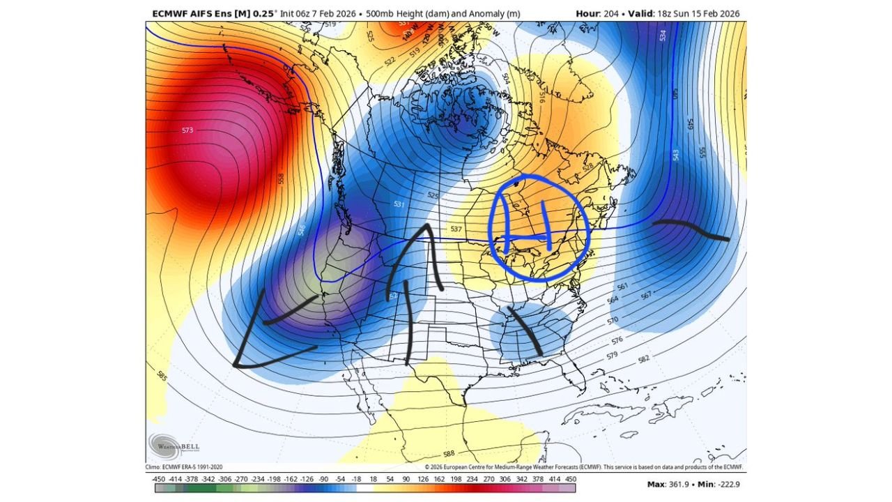
Behind the surface cold is a much larger atmospheric setup now becoming clearer in the medium-range data.
At the 500-millibar level, models show a tightening block across eastern Canada and the northeastern United States, forcing energy from the Pacific to slow, consolidate, and eventually slide underneath the block rather than escape eastward.
This shift is critical.
Earlier runs struggled with how the energy would separate, often bleeding storms harmlessly into the Atlantic. Recent guidance now favors a more consolidated wave, increasing the chance for cyclogenesis near or just off the East Coast.
Why Confidence Is Increasing for a Mid-February Storm
Forecasters point to two major reasons confidence has risen:
• Pacific energy is no longer racing east too quickly, allowing stronger interaction downstream
• The blocking high is now better resolved, encouraging redevelopment closer to the coast
This setup is historically favorable for front-end snow, especially inland, before any potential mixing near the coast.
Interior areas — including central and northern Pennsylvania, interior New York, and much of New England away from the shoreline — currently sit in a colder, more stable zone.
Snowfall Signal Expands Across the Interior Northeast
Ensemble snowfall output shows several inches of snow possible across interior sections of the Mid-Atlantic and Northeast, with the highest probabilities stretching from western Virginia through Pennsylvania, upstate New York, and into interior New England.
While coastal areas may eventually deal with mixing or rain depending on storm track, interior zones are favored to remain all snow, particularly during the early stages of the event.
The strongest snowfall signal appears tied to a front-end thump, where colder air is firmly entrenched before coastal redevelopment intensifies.
Cold Air Damming Could Play a Key Role
Another ingredient worth watching is cold air damming east of the Appalachians — a classic setup where cold, dense air becomes trapped at the surface while warmer air rides overhead.
This feature increases the risk of snow and sleet lingering longer inland, especially across Pennsylvania, northern New Jersey, and interior New England, even if coastal areas trend warmer later.
Timing Still Flexible, Impacts Could Be Significant
While nothing is locked in yet, the February 14 timeframe — give or take a day — remains firmly on the radar, with guidance suggesting the most impactful weather may actually occur a day or two after the initial target window.
Meteorologists caution that details such as exact storm track, precipitation type, and snowfall totals will continue to evolve — but the overall signal for an active and wintry period is growing stronger, not weaker.
What Residents Should Do Now
• Limit outdoor exposure during extreme wind chills
• Prepare for possible travel disruptions next weekend
• Monitor updates closely as confidence increases
With winter tightening its grip and atmospheric patterns aligning, the Northeast may be staring at one of its more consequential weather stretches of the season.
Stay tuned to WaldronNews.com for continued updates as this evolving winter pattern comes into sharper focus.