
New York, Pennsylvania, Michigan, Washington and Oregon Brace for Powerful Storm System Bringing High Winds, Rain-to-Snow Transition and Heavy Mountain Snow
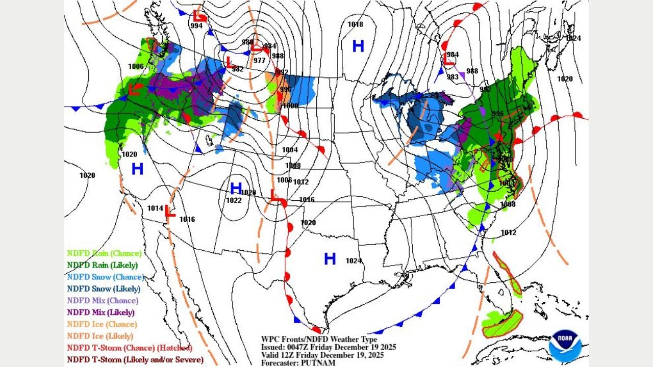
UNITED STATES — A large and powerful storm system is driving significant weather impacts across multiple U.S. states, with the most serious conditions focused on parts of the Great Lakes and Northeast and a separate but strong system affecting the Pacific Northwest. Forecast data shows damaging winds, changing precipitation types, and heavy mountain snow creating travel and safety concerns across these regions.
Great Lakes and Northeast Braced for Strong Winds and Rain Changing to Snow
States across the Great Lakes and Northeast, including Michigan, New York, and Pennsylvania, are experiencing rapidly changing weather as the storm moves east. Rain is expected to transition into snow showers, particularly in inland and higher-elevation areas, as colder air sweeps in behind the system.
Tightly packed pressure lines on forecast maps indicate gusty to strong winds, increasing the risk of downed trees, power outages, and hazardous travel.
“The quick shift from rain to snow can create dangerous, icy road conditions in a short amount of time,” forecasters warned.
Drivers are advised to prepare for reduced visibility and slick roads, especially during overnight and early morning hours.
Travel Disruptions Likely Across Impacted States
Major transportation routes in affected states may see delays due to:
- Wind-driven rain and snow
- Sudden temperature drops leading to icy pavement
- Strong crosswinds impacting high-profile vehicles
Air travel may also be disrupted as strong winds affect airport operations across the region.
Pacific Northwest Faces Heavy Mountain Snow and High Winds
At the same time, a separate storm system is impacting Washington and Oregon, bringing heavy precipitation and strong winds, with the greatest threat focused in mountainous areas. Forecast data shows significant snowfall accumulation at higher elevations, combined with gusty winds capable of producing near-blizzard conditions.
“Mountain passes could become extremely hazardous or impassable as snow intensity increases,” weather officials said.
Travel through higher terrain may be difficult due to drifting snow, poor visibility, and potential road closures.
Why This Storm Is Producing Widespread Impacts
Meteorologists attribute the storm’s intensity to a combination of:
- A strong jet stream pattern
- Sharp contrasts between warm and cold air masses
- Rapidly changing pressure systems
These conditions allow the storm to generate multiple hazards across different regions at the same time, ranging from strong winds and heavy rain to snow and blizzard-like conditions.
What Happens Next
As the system continues to move:
- Snow showers and strong winds will gradually move out of the Northeast
- Colder air will linger behind the storm
- Mountain snow in the Pacific Northwest will ease later as the system exits
Residents in all affected states are urged to monitor local forecasts, limit travel during hazardous periods, and take precautions to stay safe.
WaldronNews.com will continue to track this evolving weather situation and provide updates as conditions develop across impacted states.