
New York, Pennsylvania, New Jersey, and New England States Face Multiple Late-December Snow Chances as Forecast Models Highlight December 23–24, 27, and 30
UNITED STATES — A series of late-December weather signals is drawing close attention across the Northeast, where multiple forecast models suggest three distinct timeframes that could bring snow before the end of the year. While none of the systems appear locked in as major winter storms yet, the pattern shows repeated opportunities for accumulating snowfall, particularly across interior portions of the region.
Meteorologists emphasize that this setup is not a single storm threat, but rather a sequence of progressive systems, each capable of producing light to moderate snow depending on how moisture and cold air align.
“The signal isn’t screaming blockbuster storm — but the frequency of snow chances is notable for late December.”
December 23–24: Widespread Light Snow Potential Before Christmas
The first window arrives just ahead of Christmas, as a weak but fast-moving shortwave sweeps through the Northeast.
Forecast guidance indicates a widespread 1–4 inch snowfall is possible across parts of:
- Interior New York
- Northern Pennsylvania
- Much of New England
- Interior New Jersey and southern New York State
This system is expected to be progressive, meaning snowfall totals will depend heavily on how efficiently moisture is squeezed out of the atmosphere.
“If moisture depth improves, localized higher totals are possible — if not, amounts stay modest.”
Coastal areas may see lighter accumulations or mixed precipitation, while higher elevations and inland zones remain the most favored for measurable snow.
December 27: Colder Setup Raises Another Snow Opportunity
A second system around December 27 features a slightly colder air mass and improved atmospheric structure.
This setup introduces:
- Stronger temperature contrast (baroclinicity)
- An overrunning precipitation profile
- A better chance for snow over rain, especially inland
While still expected to move quickly, this system could deliver another round of accumulating snow, particularly across central and northern sections of the Northeast.
“This is the next system worth watching closely for meaningful snowfall.”
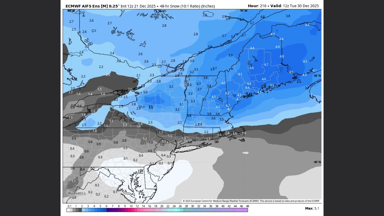
December 30: Longer-Range Signal Worth Monitoring
The third and most uncertain window arrives around December 30, driven by early long-range AI guidance.
Some model solutions suggest:
- A shift toward a negative NAO
- A westward push of the central U.S. ridge
- A more favorable storm track for the East
At this range, confidence remains low, but meteorologists caution against ignoring the signal entirely.
“The signal is faint — but it’s one of those patterns that can sharpen quickly if the blocking verifies.”
What This Means for the Northeast
Rather than a single dominant storm, the Northeast is entering a busy, changeable winter pattern marked by:
- Repeated snow chances
- Generally modest individual totals
- Potential for higher accumulations where timing and cold align
Travel impacts are most likely intermittent, especially during overnight and early-morning periods around each system’s passage.
Bottom Line
Residents across the Northeast should prepare for multiple late-December snow chances, with the December 23–24 window appearing the most immediate and widespread. Additional opportunities on December 27 and near December 30 could extend winter impacts into the final days of 2025.
Forecast confidence will continue to improve as each system approaches.
Stay ahead of developing winter weather, share your local snowfall reports, and follow ongoing coverage at WaldronNews.com for the latest updates as the Northeast’s late-December pattern unfolds.