
New York, Pennsylvania, Ohio, West Virginia, Indiana, New Jersey, Maryland, and Iowa See Widespread Snow as Alberta Clipper Drops Up to 18.5 Inches
UNITED STATES — A fast-moving but powerful Alberta Clipper winter storm swept across a large portion of the eastern and central United States, delivering widespread moderate to heavy snowfall and leaving behind significant accumulations across multiple states, according to compiled snowfall reports and regional snow maps.
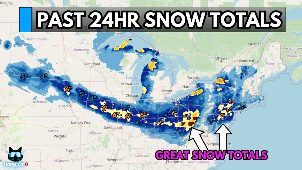
The storm packed a notable punch, producing 5 to 7 inches of snow in many locations, with localized totals far exceeding that range in areas impacted by lake enhancement and persistent snow bands.
Alberta Clipper Produces Widespread Moderate to Heavy Snow
Meteorologists say the system moved efficiently but carried enough cold air and moisture to generate steady, accumulating snowfall from the Midwest into the Appalachians and Northeast.
“This Alberta Clipper packed a punch, with widespread moderate to heavy snow of 5, 6, or 7 inches in many locations,” the snowfall summary stated.
Snow fell over a broad corridor stretching from the Plains through the Ohio Valley and into the Mid-Atlantic and Northeast, impacting major metro areas and transportation corridors.
Perrysburg, New York Records Highest Snowfall Total
The highest reported snowfall from the storm was recorded in Perrysburg, New York, where 18.5 inches of snow piled up — the largest total documented from this event.
“HIGHEST TOTAL: Perrysburg, NY — 18.5 inches,” the report confirmed.
The extreme total highlights how localized bands, especially near the Great Lakes, significantly boosted snowfall amounts in select areas.
Snowfall Totals Reported Across Multiple States
Storm-total snowfall reports show how widespread the impact was across the region:
- Perrysburg, NY — 18.5 inches
- Morgantown, WV — 12 inches
- Pittsburgh, PA — 7 inches
- Cincinnati, OH — 6 inches
- Indianapolis, IN — 6 inches
- Philadelphia, PA — 6 inches
- Columbus, OH — 5 inches
- Cleveland, OH — 5 inches
- Newark, NJ — 5 inches
- New York City, NY — 4 inches
- Des Moines, IA — 4 inches
- Baltimore, MD — 2 inches
- State College, PA — 1 inch
These totals align closely with the snow accumulation map showing a long, continuous swath of snow across the central and eastern U.S.
Lake Enhancement and Persistent Bands Boosted Totals
Forecasters note that lake-enhanced snowfall and lingering snow bands helped push totals higher in parts of New York, Pennsylvania, and the Ohio Valley. In these areas, snowfall rates increased as cold air passed over relatively warmer lake waters.
“Pretty epic snowfall for an Alberta Clipper,” the summary noted, reflecting how impactful the storm was despite its fast-moving nature.
Travel Disruptions and Cleanup Continue
Snow-covered roads, reduced visibility, and icy conditions created hazardous travel during and after the storm. Crews across affected states continue plowing and treating roads, while residents are urged to use caution during cleanup efforts.
Officials remind drivers to remain alert for refreezing overnight and changing road conditions, especially in areas that received heavier accumulations.
WaldronNews.com will continue tracking winter weather impacts and provide updates as additional snow reports and post-storm conditions develop across the region.