
New York Snowstorm Dumps Up to 30 Inches in Parts of the State Over 48 Hours, Triggering Travel Disruptions and Ongoing Cleanup Efforts
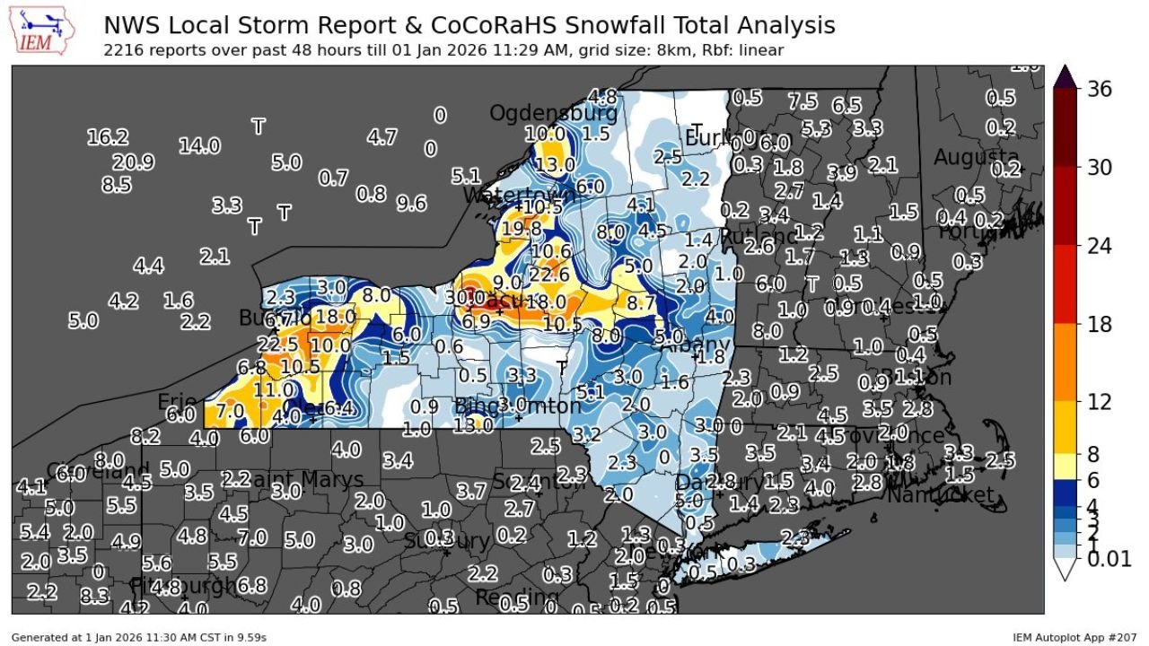
NEW YORK – A powerful winter storm system delivered significant snowfall across large portions of New York State over the past 48 hours, with some areas reporting more than two feet of snow, according to compiled local storm reports and snowfall analysis. The heaviest accumulations were concentrated across western and central New York, while lighter but still impactful snowfall extended eastward into the Hudson Valley and parts of downstate.
Data from hundreds of snow reports show that the storm intensified as it moved across the Great Lakes region, producing bands of heavy, persistent snow that led to dangerous travel conditions, scattered closures, and widespread cleanup operations as the new year began.
Heaviest Snowfall Focused in Western and Central New York
The most extreme snowfall totals were observed in lake-effect–prone regions, particularly east and southeast of Lake Erie and Lake Ontario. Communities across western New York, including areas near Buffalo and Rochester, recorded 18 to 30 inches of snow, with localized pockets exceeding that range where snow bands stalled for several hours.
In central New York, including portions of the Finger Lakes and areas surrounding Syracuse, snowfall totals commonly ranged from 8 to 16 inches, creating hazardous road conditions and prompting repeated plowing operations. Snowfall rates were reported to be heavy at times, reducing visibility and making travel difficult during peak periods of the storm.
Lighter but Disruptive Snow Extends East and South
Farther east, snowfall amounts tapered off but still caused notable impacts. Portions of eastern New York, the Hudson Valley, and parts of the Capital Region generally received 2 to 6 inches of snow, enough to create slick roadways, slow commutes, and require municipal snow removal.
Even areas closer to downstate New York, including Long Island and parts of the New York City metro area, saw lighter accumulations, though enough snow fell to impact untreated surfaces and elevate accident risks during overnight and early morning hours.
Travel Impacts and Community Disruptions
The combination of heavy snow, blowing snow, and rapidly changing conditions led to numerous travel advisories across the state. Snow-covered highways, reduced visibility, and icy secondary roads contributed to delays, spinouts, and temporary road closures, particularly in western and central regions.
Local officials urged residents to limit unnecessary travel during the height of the storm and reminded drivers to allow extra time, reduce speeds, and keep emergency supplies in their vehicles. Airports in snowbelt regions also experienced delays as crews worked to keep runways clear.
Cleanup Efforts Continue as Cold Conditions Persist
As snowfall gradually tapered off, communities shifted focus to cleanup and recovery. Plow crews worked extended shifts to clear main roads and residential streets, while homeowners and businesses began digging out from deep snowbanks left behind by repeated plowing.
Cold temperatures following the storm are expected to slow melting, meaning snow cover will likely remain in place for several days. Officials cautioned that refreezing overnight could maintain icy conditions, even after roads are cleared.
What Comes Next
While this storm has moved out, winter is far from over for New York. Meteorologists note that lake-effect snow remains possible in the days ahead, and additional winter systems could impact the region as January progresses.
Residents are encouraged to stay informed through local forecasts, continue winter safety practices, and check on vulnerable neighbors as cleanup continues.
For continued weather updates, local impacts, and storm coverage, stay connected with Waldron News.