
New York’s Hudson Valley Forecast to See Snow Tuesday, Windy Midweek, and Mostly Calm Christmas Day Conditions
HUDSON VALLEY, NEW YORK — Christmas weather across New York’s Hudson Valley is shaping up to be relatively calm and seasonable this year, following a light snowfall early in the week and a brief stretch of windy conditions midweek, according to the latest regional forecast data.
While large portions of the country — stretching from California to Indiana — are expected to experience record or near-record warmth on Christmas Day, the Hudson Valley and much of the Northeast will not be part of that unusual warmth. Instead, the region will remain cooler and more seasonable as Canadian air masses maintain influence.
“It won’t be frigid, but it won’t exactly be warm either.”
Light Snow Expected Tuesday Before Conditions Improve
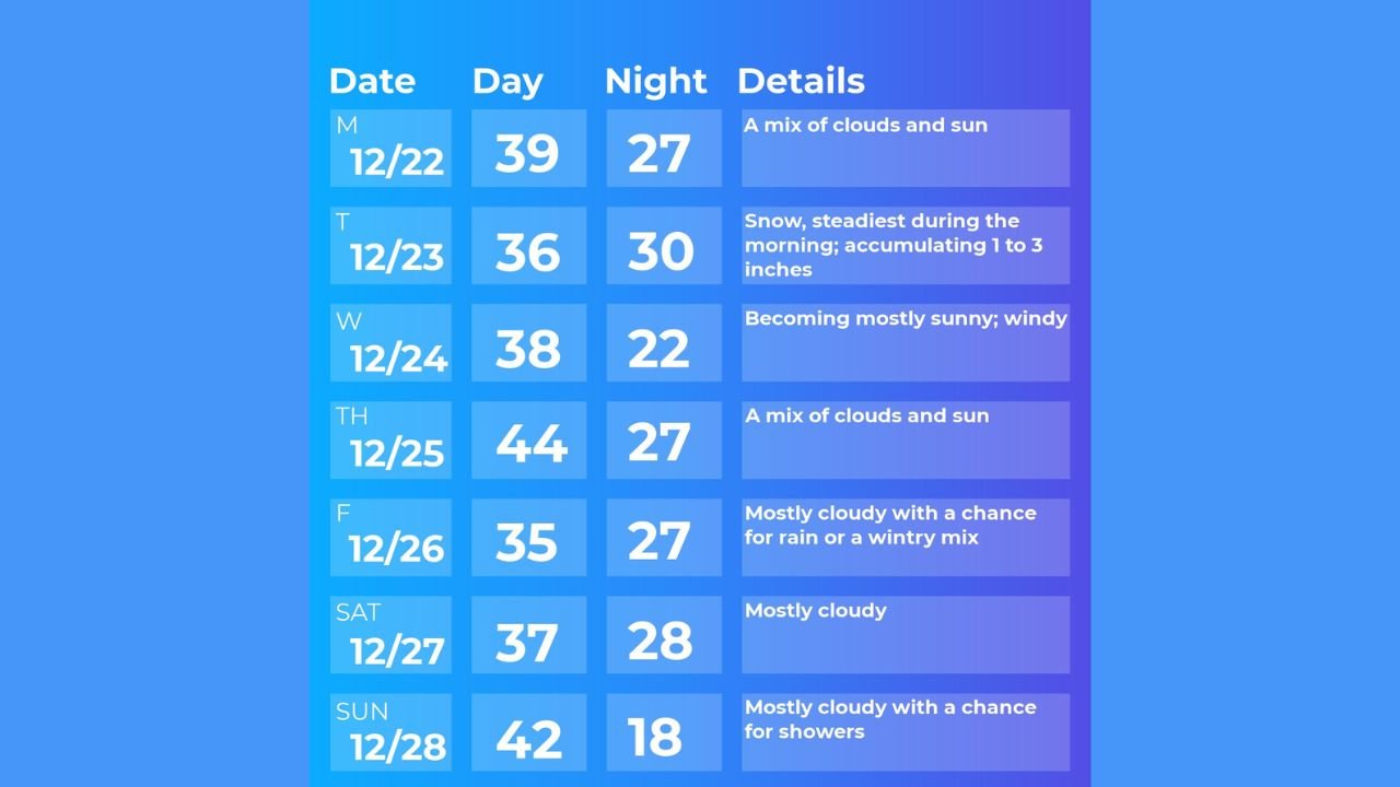
Forecast data indicates that Tuesday will bring a period of snowfall, with accumulations generally expected to range between 1 and 3 inches, particularly during the morning hours.
This snow event marks the most notable weather impact of the week and could briefly affect travel before tapering off later in the day.
Wednesday Turns Windy as Skies Gradually Clear
Following Tuesday’s snowfall, conditions are expected to improve on Wednesday, though it will be noticeably windy as colder air settles in behind the departing system.
Skies are forecast to become increasingly sunny through the day, helping dry out roads and surfaces ahead of Christmas Eve night.
Christmas Day Looks Mostly Dry and Seasonable
Current projections show Christmas Day shaping up as fairly quiet across the Hudson Valley, with a weak weather system expected to pass south of the region, limiting any precipitation locally.
Thursday is expected to feature:
- Partly sunny skies
- Dry conditions
- Seasonable temperatures
This should allow for relatively smooth holiday travel and outdoor plans across the region.
“Christmas Day looks pretty decent at this point.”
Hudson Valley Stays Cooler as Much of the U.S. Turns Unusually Warm
While approximately 20 states across the central and western U.S. are expected to see record or near-record highs on Christmas, the Hudson Valley and broader Northeast will remain cooler.
This is due to Canadian air masses continuing to overpower warmer air attempting to move in from the Southwest, keeping temperatures closer to normal for late December.
Additional Storm Chances Later in the Week
Looking beyond Christmas, forecast guidance suggests two to three additional systems could impact the region later in the week:
- Friday: Another storm approaches; depending on its track, it could bring rain or a wintry mix
- Saturday: Likely drying out
- Sunday: Another frontal system may pass through, bringing a chance of rain
Temperatures are expected to fluctuate but remain generally seasonable.
Outlook for Late December and the Start of the New Year
Looking ahead to the week of December 29, forecasts suggest the Hudson Valley may start off colder before moderating slightly around the beginning of the new year.
No major winter storms are clearly indicated at this time, but forecasters stress that late-December patterns can change quickly.
“The colder air returns first — storms come later.”
How is the holiday weather shaping up where you live in the Hudson Valley? Share your local conditions and stay up to date with regional forecasts at WaldronNews.com.