
Nor’easter Potential Builds for Virginia, Maryland, Delaware, Pennsylvania, New Jersey, and New York as Embedded Energy Targets East Coast, Colder Air to Follow
EAST COAST – The potential for a late-weekend into early-next-week Nor’easter remains on the table, and the latest ECMWF guidance shows a pattern that could still deliver a meaningful coastal storm — if the timing and interaction of several embedded energy pieces align close enough to shore.
The setup is complex, featuring multiple shortwaves racing east within a strong jet stream. Whether those pieces “connect” in the right location will determine if this becomes a significant coastal system or another offshore miss.
Upper-Level Pattern Shows Strong Eastern Trough
The 500mb height and anomaly map valid early Monday highlights a pronounced trough digging across the eastern United States. A deep pocket of below-normal heights extends from the Tennessee Valley through the Carolinas and Mid-Atlantic, signaling an environment supportive of cyclogenesis off the coast.
Meanwhile, a strong ridge dominates the western U.S., helping to amplify the eastern trough. That ridge-trough configuration is often a key ingredient for East Coast storm development.
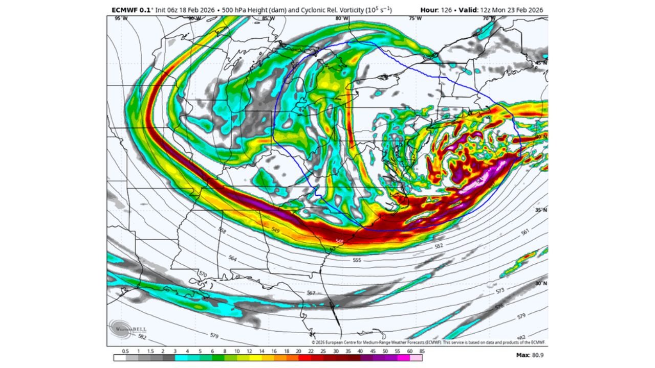
Jet Stream Energy Racing East
The 500mb vorticity map shows several embedded lobes of energy rotating through the base of the trough. A powerful jet streak arcs across the southern U.S. and then intensifies offshore of the Southeast and Mid-Atlantic coast.
This type of jet configuration can:
- Promote rapid coastal low development
- Enhance lift near the Mid-Atlantic shoreline
- Support stronger banding if phasing occurs at the right time
But the interaction timing is critical. If the pieces remain disconnected or phase too late, the low could stay farther offshore.
Coastal Low Development Near the Mid-Atlantic
The surface pressure and precipitation panel depicts a developing low off the Mid-Atlantic coastline, with rain and snow wrapping around its northwest flank. The 1000-500mb thickness lines suggest colder air wrapping in behind the system across the Appalachians and interior Northeast.
Snow potential appears focused:
- Inland from the immediate coast
- Across parts of Pennsylvania, upstate New York, and interior New England
- With rain/mix closer to the coastal plain depending on track and thermal profiles
Again, this remains highly track-sensitive.
Upper-End Potential If “Dots Connect” Closer to Land
Forecasters are emphasizing that this pattern carries upper-end potential. The ingredients are present:
- Strong jet dynamics
- A digging trough
- Available cold air
- Offshore baroclinic zone
If the shortwaves consolidate closer to the coast, the Mid-Atlantic and Northeast could see a more impactful Nor’easter scenario. If consolidation occurs farther east, heavier precipitation bands would remain offshore.
At this lead time, declaring it a complete miss would be premature.
Colder, More Widespread Air Follows Regardless
One of the clearer signals is the cold that follows. The 2-meter temperature anomaly map for Days 5–6 shows:
- Widespread below-normal temperatures across the Midwest, Great Lakes, Ohio Valley, and East Coast
- More expansive and colder anomalies compared to previous runs
Even if the coastal storm underperforms, a colder air mass looks likely to settle across much of the eastern U.S. early next week.
Bottom Line
Nor’easter potential remains alive for late weekend into early next week across Virginia, Maryland, Delaware, Pennsylvania, New Jersey, and New York. The pattern features multiple energy pieces that could combine into a stronger coastal low — but timing and location of phasing are everything.
Regardless of storm outcome, colder air is trending stronger and more widespread behind the system.
For continued East Coast winter storm tracking and pattern breakdowns, stay with WaldronNews.com for the latest updates.