
Nor’easter Threat Grows for Sunday–Monday as Models Signal Potential Coastal Low Near New York and New England
UNITED STATES — A growing signal in the latest forecast guidance suggests a developing nor’easter could impact parts of the Mid-Atlantic and Northeast Sunday into Monday, with potential storm tracks clustering just offshore of New Jersey, New York, and southern New England.
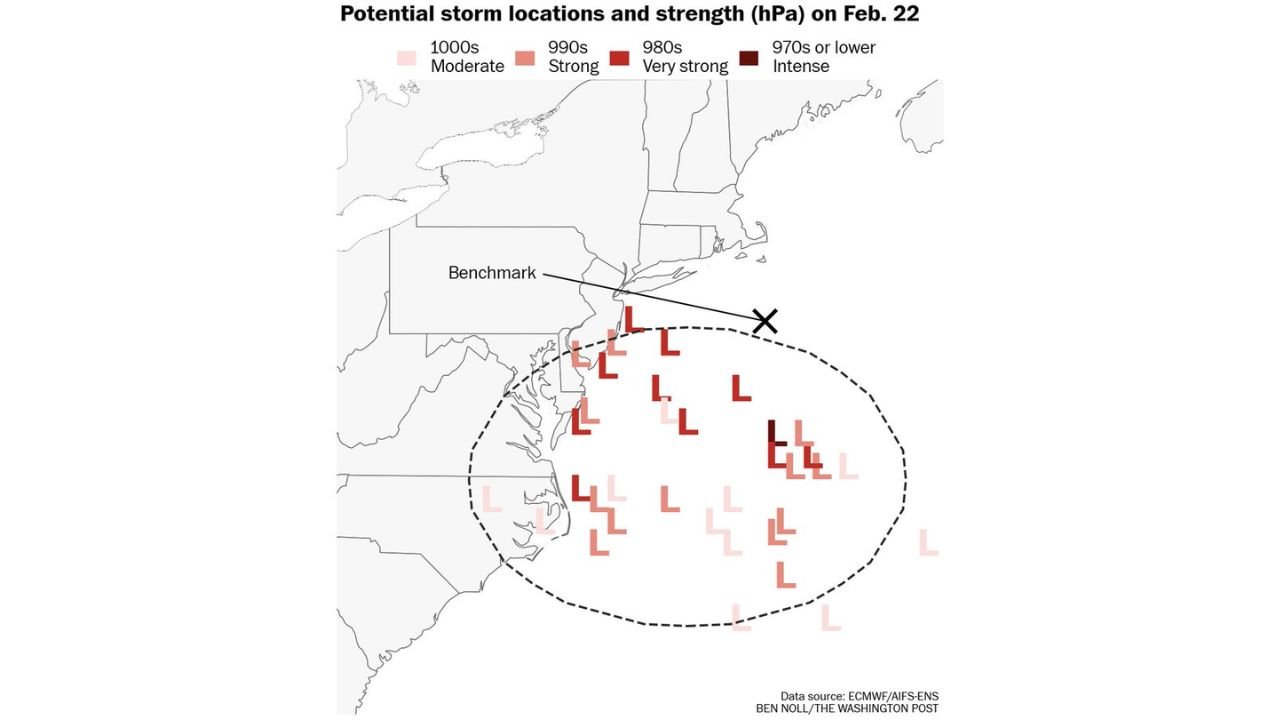
New ensemble data highlighting possible storm locations and central pressure strengths for February 22 show a concentrated area of low-pressure development off the East Coast. While exact impacts remain uncertain, the setup is increasingly being monitored for a coastal storm that could either deliver a glancing blow or a more direct hit depending on track.
Cluster of Possible Low-Pressure Centers Off the Northeast Coast
The latest model ensembles depict numerous projected “L” positions scattered over the western Atlantic, primarily east and southeast of the Delmarva Peninsula, New Jersey, and Long Island. The clustering suggests:
- A majority of solutions keep the storm offshore
- Several stronger scenarios deepen the system into the 980s millibar range
- A few lower-probability members intensify into the 970s or lower, indicating a potentially intense coastal storm
A benchmark reference near the 40°N / 70°W region — commonly used in nor’easter forecasting — is shown on the map. Storms that track near or just west of that benchmark historically bring significant snow and wind to parts of the Northeast. Storms staying farther south or east tend to limit major impacts to coastal areas.
At this stage, the projected track envelope remains broad.
Sunday Into Monday Timing Window
The potential event timeframe is focused on:
- Sunday afternoon through Sunday night
- Lingering impacts into Monday morning
The uncertainty centers on how quickly energy consolidates along the coast and whether upper-level support phases efficiently enough to allow rapid strengthening. A tighter, closer-to-shore track would increase the likelihood of:
- Heavier precipitation along the I-95 corridor
- Strong coastal winds
- Possible snowfall inland depending on thermal profiles
A flatter, weaker solution would keep the storm mostly offshore with limited precipitation reaching land.
What the Pressure Spread Suggests
The ensemble spread indicates varying storm intensities:
- 1000s mb systems: Moderate coastal lows
- 990s mb systems: Stronger nor’easters capable of widespread impacts
- 980s mb systems: Very strong storms with heavy precipitation and strong winds
- 970s or lower: Intense coastal cyclones with significant wind potential
While only a handful of ensemble members show the most intense outcomes, the presence of those stronger solutions highlights the need for continued monitoring.
Track Will Determine Who Sees the Worst Impacts
The biggest question remains:
Does the storm slide south and east, or does it hug the coastline?
A slight shift north or west could dramatically increase impacts for:
- Eastern Pennsylvania
- New Jersey
- New York City
- Long Island
- Southern New England
Meanwhile, a more offshore track would spare many inland locations from major effects.
Forecast confidence this far out remains moderate at best, as small changes in upper-level energy and jet stream alignment will ultimately determine the outcome.
What Happens Next
Over the next several days, model consistency will be critical. If ensemble clustering tightens and trends toward a closer coastal solution, confidence in measurable impacts will increase.
For now, this remains a developing signal rather than a locked-in storm.
Residents across the Mid-Atlantic and Northeast should stay tuned for updated guidance as the Sunday–Monday window approaches.
WaldronNews.com will continue monitoring trends and provide updates as confidence improves.