
North Carolina and South Carolina Face Potentially Historic Snowstorm as Heavy Snow Signals Increase for January 31–February 1
NORTH CAROLINA / SOUTH CAROLINA — A developing winter storm is showing strong signals for widespread heavy snowfall across central and eastern North Carolina extending into South Carolina, according to the latest broad-brush forecast data released ahead of the January 31 to February 1 storm window.
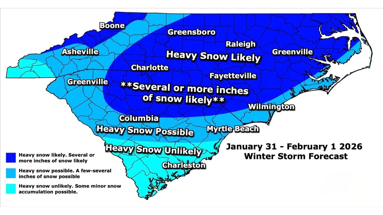
Meteorologists caution that while exact snowfall totals are still being finalized, the current setup supports the potential for several inches or more of snow across a large multi-state region, with some of the highest impacts centered over inland portions of the Carolinas.
Heavy Snow Likely Across Central and Eastern North Carolina
Forecast mapping indicates that most of central and eastern North Carolina falls within the zone labeled “Heavy Snow Likely,” meaning several or more inches of accumulation are possible if the storm evolves as projected.
Major population centers including Raleigh, Greensboro, Fayetteville, Greenville, and Charlotte are all positioned within or very near the highest-confidence snowfall zone. This raises concerns for significant travel disruptions, hazardous road conditions, and potential infrastructure strain should snow rates intensify.
Snow Threat Extends South Into South Carolina
The winter storm signal does not stop at the state line. Central South Carolina, including the Columbia area, is currently highlighted for heavy snow possible, with a realistic chance of a few to several inches depending on storm track and thermal profiles.
Farther south, coastal and southern South Carolina, including Charleston and surrounding Lowcountry areas, remain in a lower-confidence zone where heavy snow is considered unlikely, though minor accumulations cannot be ruled out.
Coastal Areas Face Lower Confidence but Still at Risk
While inland areas show the strongest signal for snow, coastal cities such as Wilmington and Myrtle Beach remain near the southern edge of heavier snowfall potential. Small shifts in storm track could still alter outcomes, especially along the immediate coast where temperature profiles and precipitation type often play a decisive role.
Snow Totals Still Pending, but “Gigantic Numbers” Possible
Meteorologists behind the forecast emphasize that specific snowfall totals will not be released until later, but acknowledge that some areas may ultimately see very large accumulation numbers on finalized maps.
The current guidance is intended as a high-level impact overview, signaling that this storm has the potential to be one of the more significant Carolinas snow events in recent years, depending on how remaining details resolve.
Timing: Late January Into Early February
The storm is currently forecast to impact the region during the January 31 through February 1 timeframe, placing it squarely over the weekend period. This timing could magnify impacts by affecting regional travel, deliveries, and emergency response capabilities across both states.
What Residents Should Do Now
Even without final totals, the forecast confidence in widespread impactful snowfall means residents should begin preparing by:
- Monitoring forecast updates closely over the next 24–36 hours
- Reviewing winter travel plans
- Ensuring vehicles and homes are winter-ready
- Planning for potential delays or closures
Further refinement of snowfall amounts and impact zones is expected as the storm approaches.
Stay with WaldronNews for continued updates, refined snowfall projections, and impact-focused coverage as this potentially major Carolinas winter storm comes into clearer focus.