
North Carolina and Virginia Face Highest Winter Storm Risk This Weekend as Snow and Ice Chances Increase Across South Carolina and Georgia
NORTH CAROLINA — Confidence is increasing that a significant winter weather event could impact parts of the Carolinas and southern Appalachians this weekend, with the highest probabilities currently focused across central and northern North Carolina and southern Virginia, according to the latest winter weather outlook.
Forecast guidance issued Tuesday morning shows winter storm chances trending upward 4–5 days out, a notable signal at this lead time. While exact precipitation types and placement remain uncertain, forecasters caution that this system carries the potential for snow, sleet, and significant ice accumulation, especially given very cold surface temperatures expected to be in place.
Highest Probabilities Centered Over North Carolina and Southern Virginia
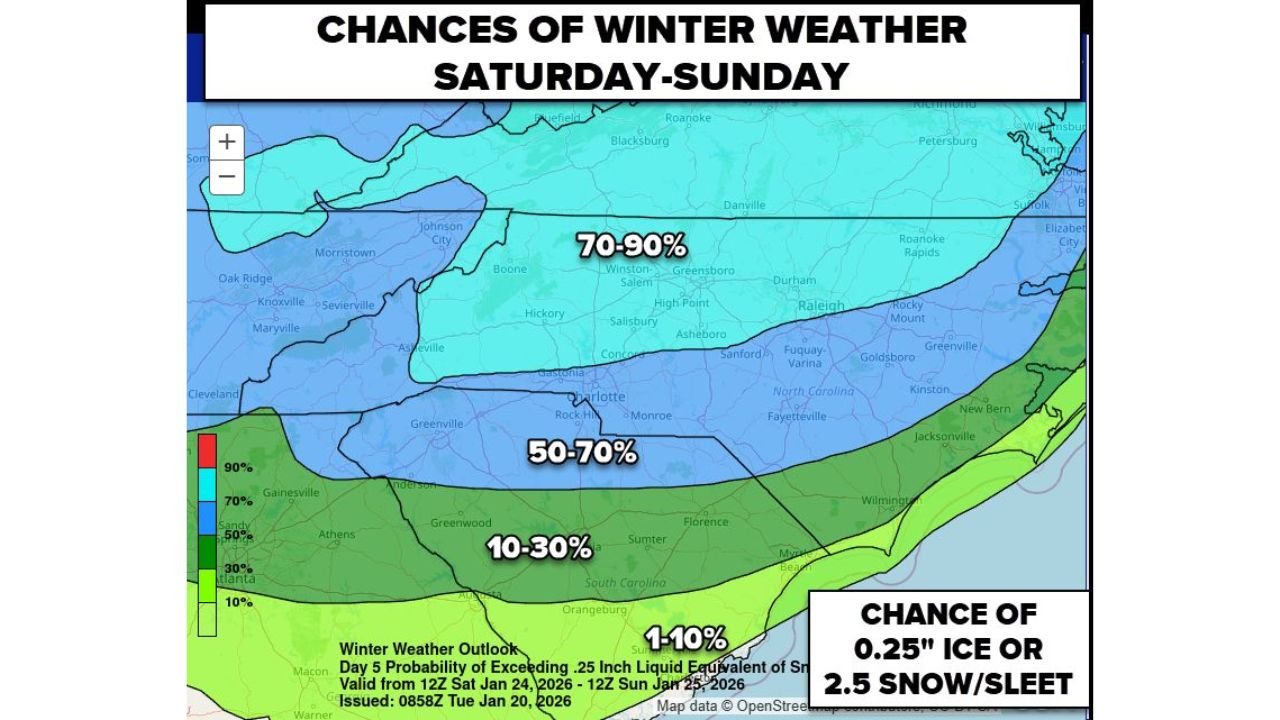
The latest probability map highlights a 70–90% chance of impactful winter weather across a broad corridor of central North Carolina into southern Virginia, including areas near Winston-Salem, Greensboro, and surrounding regions.
South of that zone:
- A 50–70% probability extends into parts of western and central North Carolina
- A 10–30% probability stretches into northern South Carolina
- Coastal South Carolina and southern Georgia currently sit in a 1–10% range, though these probabilities could change as the forecast evolves
These probabilities represent the chance of exceeding 0.25 inches of ice or 2.5 inches of snow/sleet, thresholds that can quickly lead to hazardous travel and infrastructure impacts.
Ice Threat a Major Concern Along the Southern Edge
Forecasters stress that this system should not be viewed as a snow-only event. The southern edge of the precipitation shield may experience significant ice accumulation, especially where cold air near the surface becomes trapped beneath warmer air aloft.
With surface temperatures expected to be very cold, any freezing rain or sleet would:
- Accumulate efficiently on roads, trees, and power lines
- Create dangerous travel conditions
- Increase the risk of power outages if ice amounts trend higher
This makes small changes in storm track and temperature profiles especially important over the coming days.
Timing: Late Saturday Into Sunday
Current guidance places the main winter weather window from Saturday into Sunday, though exact start and end times may shift as models refine the storm’s path.
Meteorologists emphasize that the system’s track will determine:
- Where the heaviest snow sets up
- How far south ice threats extend
- Which communities experience the greatest impacts
Because of this, forecast confidence on impacts is higher than confidence on exact locations at this stage.
What Residents Should Do Now
With winter storm probabilities already elevated several days out, residents across North Carolina, Virginia, South Carolina, and Georgia are encouraged to:
- Monitor forecasts daily
- Prepare for potential travel disruptions
- Avoid focusing on snowfall totals alone, as ice may be the bigger hazard
Further updates are expected as higher-resolution models come into range later this week.
Stay informed and keep checking back with Waldron News for the latest winter storm updates, probability changes, and impact-focused forecasts as this weekend system comes into sharper focus.