
North Carolina Braces for Fast-Moving Monday Snowstorm as New HRRR Model Shows Heavier Bands and “Surprise” Zones
NORTH CAROLINA — A fast-moving winter storm is expected to sweep across the state on Monday, bringing another round of accumulating snow to areas that already received snowfall on Friday — and potentially spreading wintry conditions farther south than the last system. Updated HRRR model runs indicate a sharper push of cold air and a more aggressive swath of snowfall, raising concerns for both Western North Carolina and the Eastern “surprise zone” highlighted by forecasters.
The National Weather Service and several high-resolution models show a compact but potent system capable of producing quick bursts of heavy snow, including bands strong enough to create jackpot zones with the highest totals.
Backside Energy Could Create Heavier Snowfall in Western North Carolina and Southern Appalachians
Meteorologists are increasingly confident that backside energy will enhance snow rates late in the event, especially across:
- Southern West Virginia
- Southwest Virginia
- Northwest North Carolina
- Extreme Northeast Tennessee
These areas sit in the prime position for localized 1–2 inch per hour snow bursts, where cold air meets deeper moisture trailing behind the departing low.
Forecasters say this zone has the potential to become the “jackpot area” of the storm.
A weather analyst watching the setup explained:
“This is the type of storm where the last few hours can end up delivering the most impactful snow. Backside dynamics will drive heavier rates as the low pulls away.”
Eastern North Carolina and Southeast Virginia in Play for a Surprise Snow Area
The second region attracting attention is Eastern North Carolina into Southeast Virginia, where enhanced precipitation could overlap just enough cold air to generate unexpectedly higher snowfall totals.
This region has been labeled a possible “surprise area,” especially near:
- Rocky Mount
- Greenville
- Elizabeth City
- Into the Hampton Roads region of Virginia
Some HRRR runs show colder profiles than previous days, enough to support light-to-moderate accumulating snow before precipitation exits Monday afternoon.
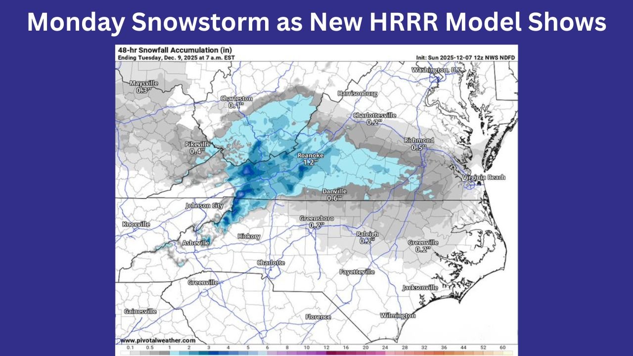
Snowfall Projections: Light to Moderate Totals, Heaviest North and West
New National Weather Service accumulation maps show:
- Roanoke, VA: ~1.2 inches
- Danville, VA: ~0.6 inches
- Raleigh–Durham, NC: ~0.2 inches
- Charlotte, NC: A trace to light coating
- Greensboro, NC: ~0.2 inches
HRRR snapshots suggest a broader coverage of snowfall compared to earlier model cycles. Snow may begin in western areas early Monday morning, spreading eastward into midday.

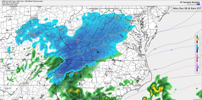
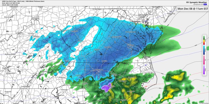
Several HRRR panels included in the analysis show widespread blue shading across:
- The North Carolina Piedmont
- Virginia foothills
- Portions of I-95 in Eastern North Carolina
This raises the likelihood of slippery travel during the late morning through early afternoon.
Timing of the Storm Across North Carolina
Monday Morning (6 AM – 10 AM)
Snow reaches Appalachian counties and spreads across the Triad and parts of southern Virginia. Some pockets of moderate snow possible.
Late Morning to Midday (10 AM – 1 PM)
Peak snowfall period for central and eastern North Carolina. Bands of heavier snow possible depending on storm track.
Afternoon (1 PM – 4 PM)
Storm begins to exit into the Atlantic. Lingering flurries possible west of Raleigh.
Forecasters Caution: Small Track Adjustments Could Change Totals
Even though this is a fast-moving system, the models remain sensitive to subtle shifts. Better-aligned cold air could push snow totals higher; a warmer surface profile could lower them.
One forecaster added:
“These are the kinds of storms where a 25-mile wobble can completely change who gets an inch and who gets nothing.”
What Residents Should Expect
- Slippery roads for the morning and midday commute
- Quick bursts of snow capable of reducing visibility
- Localized moderate accumulation in jackpot zones
- Possible surprise totals east of I-95 if cold air deepens faster than expected
- Cold rain for far southern North Carolina and South Carolina
Final Outlook
This storm is not expected to be major, but its speed, intensity, and expanding southern reach make it one worth watching closely — especially for North Carolina residents hoping for a second round of early-season snowfall.
For more breaking winter weather updates across the Carolinas and the Eastern U.S., stay with WaldronNews.com — your source for accurate, fast, and local weather reporting.