
North Carolina Radar Alert: Brief Snow Flurries Possible Near Greensboro for the Next Hour, No Impacts Expected
NORTH CAROLINA — A quick, light burst of wintry weather may brush parts of the Greensboro area late this morning, with radar suggesting passing snow flurries or brief snow showers could move through over the next 30 minutes to an hour. The update indicates no impacts are expected, meaning roads and travel conditions should remain largely unchanged.
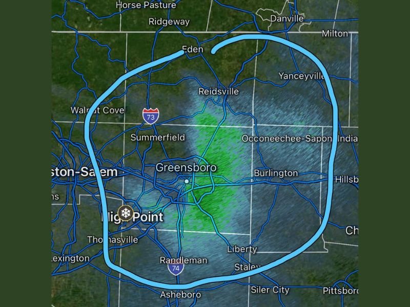
What the radar is showing right now
The radar snapshot highlights a narrow, moving area of light returns centered near Greensboro, with nearby communities including Summerfield, Reidsville, Burlington, Liberty, Asheboro, High Point, Eden, and Yanceyville also within the broader zone where flurries could briefly appear.
This type of setup typically produces spotty, short-lived flakes—sometimes visible in the air without accumulating—especially if temperatures are hovering near freezing and the moisture layer is shallow.
Timing and where you might notice flakes
Forecasters expect the window to be short:
- Timing: roughly 30 to 60 minutes
- Coverage: hit-or-miss, with some neighborhoods seeing a quick burst while others see little to nothing
- Intensity: generally light, consistent with flurries or brief showers rather than a steady snow
Because this is a fast-moving, light event, it’s common for the “most noticeable” flakes to show up for just a few minutes in any one location before tapering off.
Why “no impacts” matters
When an update says no impacts expected, it usually means:
- No meaningful accumulation is anticipated
- Road conditions are not expected to deteriorate
- Any flakes that do fall are more likely to be brief and non-sticking, especially on treated or warmer pavement
Still, if you’re driving, it’s always smart to stay alert for isolated slick spots on bridges or shaded areas—just in case a quick burst lines up with colder surfaces.
What to watch for next
If you’re in or near the Greensboro metro, the best way to gauge what you’ll actually get is simple: look outside for a couple minutes, then re-check radar shortly after. These quick flurry bands often fade as quickly as they appear.
Have you seen flakes where you are? Share what you’re getting in your area, and keep following waldronnews.com for more quick-hit weather updates and developing conditions.