
North Carolina Snow Chances Drop Sharply as Sunday Winter Impacts Now Look Limited, Forecasters Warn of Refreezing Roads Overnight
NORTH CAROLINA — Updated forecast guidance shows a continued downward trend in snowfall potential across central North Carolina, significantly reducing the likelihood of impactful winter weather on Sunday. According to the latest National Weather Service outlooks, most of the region now has less than a 15 percent chance of seeing 1 inch or more of snow, with overall impacts expected to remain limited.
Meteorologists say the primary concern is no longer snowfall totals, but rather road conditions late Sunday night as colder air moves in and temperatures drop below freezing.
Snowfall Probabilities Continue to Trend Lower
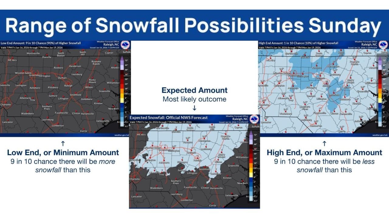
Forecast models analyzed Saturday evening show minimal snow accumulation across much of central North Carolina, including the Raleigh–Durham region and surrounding counties.
Key points from the latest data include:
- Probabilities for 1 inch or more of snow are mostly below 15%
- Most locations are expected to see little to no accumulation
- Any snow that does fall is expected to be light and short-lived
- Higher snowfall totals now appear increasingly unlikely
The most likely outcome, based on official National Weather Service projections, is a trace to very light snowfall, with many areas seeing no measurable snow at all.
Primary Concern Shifts to Refreezing Roads Sunday Night
While snowfall impacts look limited, forecasters stress that wet roads could become hazardous late Sunday night as colder air settles into the region.
Important safety concerns include:
- Rain or drizzle earlier in the day may freeze overnight
- Untreated roads, bridges, and overpasses could become slick
- Black ice is possible despite minimal snowfall
Drivers are urged to use caution late Sunday evening and early Monday morning, especially in shaded areas and on elevated roadways.
Expected Timing of Weather Impacts
Based on current guidance:
- Any light precipitation would occur Sunday
- Temperatures are expected to fall below freezing Sunday night
- Refreezing conditions may develop overnight into early Monday
Forecasters emphasize that even limited winter weather can still cause travel problems when temperatures drop quickly.
What Residents Should Do
Officials recommend taking basic winter precautions despite the lower snow risk:
- Slow down and increase following distance while driving
- Be alert for icy patches after dark
- Allow extra travel time Monday morning
- Monitor updated forecasts in case conditions change
While confidence is increasing that this will be a low-impact winter event, weather officials caution that small changes in temperature can still lead to localized hazards.
Bottom Line
Snow chances across North Carolina have decreased significantly for Sunday, and widespread accumulation is no longer expected. However, refreezing roads late Sunday night remain a concern, particularly where moisture lingers.
Residents are encouraged to stay weather-aware and use caution, even as the overall threat continues to diminish.