
North Carolina, South Carolina, and Charlotte Area Face Multi-Night Freeze Threat as Temperatures Drop to Mid-20s Despite Limited Warnings
NORTH CAROLINA — A prolonged stretch of freezing temperatures is set to impact the Carolinas, with forecasters warning that even areas not officially under freeze alerts will likely experience damaging cold over the next several nights.
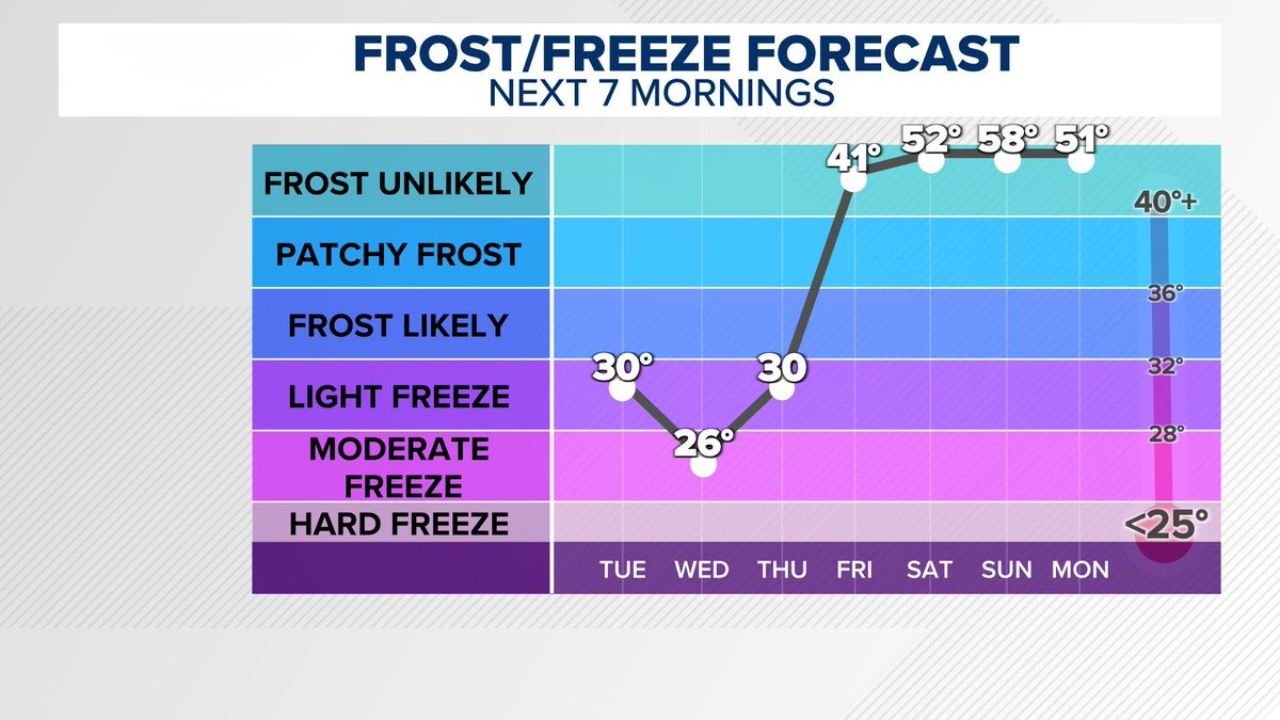
New forecast data shows multiple mornings dipping into the 20s and low 30s, raising serious concerns for gardeners, agriculture, and sensitive outdoor plants across North Carolina and South Carolina.
Three Consecutive Nights of Freeze Conditions Expected
The latest temperature outlook for the Charlotte region and surrounding areas shows a clear and concerning trend:
- Tuesday morning: Around 30°F (light freeze conditions)
- Wednesday morning: Near 26°F (moderate freeze)
- Thursday morning: Around 30°F (another light freeze)
These temperatures fall squarely within the range where frost and freeze damage becomes likely — especially after early spring growth has already begun.
Why This Freeze Threat Is Significant
Even though some locations may not be under official freeze warnings, the impact could still be widespread.
Key concerns include:
- Plant damage: Early blooms and vegetation are highly vulnerable
- Agricultural losses: Crops and fruit trees may be affected
- Garden risks: Unprotected plants could suffer significant damage
The biggest issue is timing — with warmer weather prior to this cold snap, many plants have already started growing, making them more susceptible.
Understanding the Freeze Levels
The forecast highlights different categories of cold conditions:
- Frost likely (around 30–32°F): Patchy frost formation possible
- Light freeze (28–32°F): Damage to sensitive plants likely
- Moderate freeze (25–28°F): More widespread vegetation damage
With temperatures expected to drop as low as 26°F, parts of the region will experience conditions strong enough to cause noticeable impacts.
Rapid Warm-Up to Follow
After the cold stretch, temperatures are forecast to rebound quickly:
- Friday morning: Around 41°F
- Weekend mornings: Rising into the 50s
- Early next week: Staying above freezing
This sharp swing highlights the volatility of early spring weather in the Southeast, where warm and cold air masses frequently collide.
Why Some Areas May Not Have Official Warnings
Meteorologists note that freeze warnings are issued based on specific criteria, including:
- Duration of freezing temperatures
- Geographic coverage
- Growing season considerations
However, localized conditions can still lead to freezing temperatures even if a formal warning is not issued — which is why residents are being urged to prepare regardless.
What Residents Should Do Now
With several freezing mornings ahead, experts recommend:
- Covering or bringing in sensitive plants
- Protecting outdoor plumbing if necessary
- Monitoring local temperature updates closely
Even a few hours below freezing can be enough to cause damage, especially during early spring.
Bottom Line
A multi-night freeze event is set to impact North Carolina, South Carolina, and the Charlotte region, with temperatures dropping into the 20s and low 30s through midweek.
- Three consecutive mornings of freeze conditions expected
- Temperatures as low as 26°F possible
- Plant and agricultural damage likely in some areas
Residents should not rely solely on official warnings and should take precautions now to protect vulnerable plants and property.
Stay with WaldronNews.com for continued updates as this late-season cold snap unfolds across the Carolinas.