
North Carolina, South Carolina, and Georgia Brace for Friday-to-Saturday Snowstorm as High Odds of 2–4 Inches Emerge Near Charlotte and the Upstate
UNITED STATES — A developing winter storm is increasingly likely to bring accumulating snow from Friday night through Saturday night across parts of North Carolina, South Carolina, and northeast Georgia, with forecast data now showing high probabilities of impactful snowfall across the Charlotte metro, the western Piedmont, and the South Carolina Upstate.
While exact totals are still being refined, multiple probability maps indicate that this system has the potential to disrupt travel and daily life across a broad multi-state corridor.
Accumulating Snow Expected Friday Night Through Saturday Night
Forecasters indicate that snow will overspread much of the region late Friday, continuing through Saturday night, with accumulation likely in many areas.
- Snowfall timing: Friday night through Saturday night
- Event duration: Prolonged, not a quick burst
- Snowfall coverage: Widespread across western NC, Upstate SC, and northeast GA
The uncertainty now centers on how heavy the snow becomes and where the strongest bands set up.
High Confidence for 2+ Inches in North Carolina and South Carolina
Probability data from the Greenville–Spartanburg forecast area shows strong confidence in at least 2 inches of snow, especially east of the mountains.
Notable probabilities include:
- 80–90% chance of 2+ inches across the Charlotte metro, Hickory, Statesville, Salisbury, Rock Hill, and Monroe
- 60–70% probabilities across much of the Upstate South Carolina, including Greenville, Spartanburg, and Laurens
- Lower but notable probabilities extending into northeast Georgia
This suggests that most areas in the core zone will see plow-able snow, even if totals vary locally.
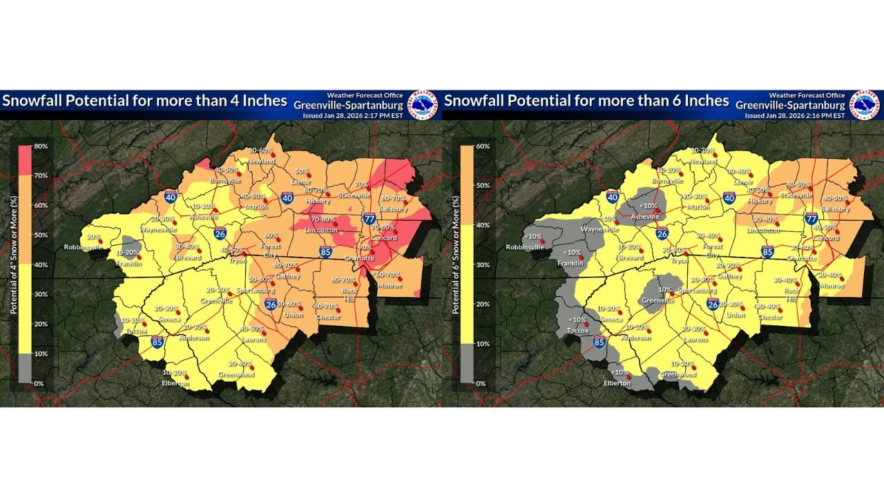
4-Inch Snow Potential Rises in the Piedmont and Charlotte Area
The risk for more significant snowfall is becoming clearer.
- 60–80% chance of 4+ inches near Charlotte, Concord, Rock Hill, and parts of the NC Piedmont
- 40–60% probabilities across the Upstate of South Carolina
- Mountain valleys and far southwest areas show lower probabilities, but still non-zero risk
These probabilities point to a realistic scenario where parts of the region exceed typical winter snow amounts.
6-Inch Snow Possible, but Confidence Drops
Heavier totals remain possible, though with lower confidence.
- 30–40% chance of 6+ inches near Charlotte and eastern Piedmont areas
- 20–30% probabilities across portions of the Upstate
- Less than 10% west of the mountains and into far northeast Georgia
This suggests localized heavy bands could push totals higher, especially if snow persists longer than expected.
Moderate Winter Storm Impacts Likely
Impact guidance shows a moderate risk of winter storm disruptions, particularly east of the mountains.
- Hazardous driving conditions likely
- Travel delays possible Friday night through Saturday
- Impacts strongest in North Carolina Piedmont and northern South Carolina
Even areas with lower snowfall totals could see meaningful impacts due to timing and cold road surfaces.
What Happens Next
Forecasters stress that snow totals and band placement are still being refined, and changes remain possible.
Key questions still being resolved:
- Exact placement of the heaviest snow band
- Final snowfall totals by county
- Duration of steady snow Saturday night
WaldronNews Weather Alert
A multi-state winter storm is shaping up across North Carolina, South Carolina, and Georgia, with accumulating snow likely from Friday night through Saturday night and high confidence in impactful snowfall near the Charlotte metro and Upstate South Carolina.
Stay with WaldronNews for continued updates as snowfall maps are refined and confidence increases heading into the weekend.