
North Carolina, South Carolina and Georgia Watching Arctic Air Surge as Possible Southern Storm Could Decide Rain, Ice or Snow Next Weekend
UNITED STATES — A departing rain system across the Carolinas is giving way to growing attention on next weekend’s weather pattern, as forecasters monitor whether a potential southern storm system could interact with incoming Arctic air across parts of the Southeast, including North Carolina, South Carolina, and Georgia, between January 24 and January 25.
Rain Ends, Cold Air Falls Short for Snow in the Carolinas
Early reports of brief flurries west of Interstate 95 in parts of South Carolina were short-lived and failed to accumulate. The reason was clear: cold air lagged behind the moisture, preventing rain from changing to snow before precipitation ended.
Rain is expected to fully exit within a short time, but colder temperatures following the system may raise black ice concerns overnight, especially on untreated roads and bridges.
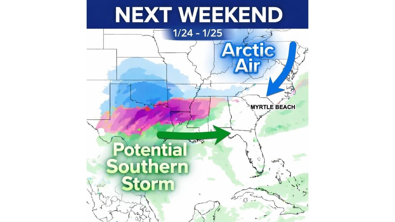
Attention Turns to Next Weekend’s Southern Storm Potential
With the current system moving out, meteorologists are now closely watching model guidance for next weekend, when a storm may develop across the Deep South and attempt to track east toward the Carolinas.
Southern-origin storms often offer the best chance for winter weather in the Southeast because they can tap Gulf moisture while cold air presses south from the north. However, confidence remains very low at this stage.
Forecasters stress that it is still too early to know whether a storm will even form.
Arctic Air Will Be in Place — But Moisture Is Not Guaranteed
Model trends suggest much colder Arctic air will likely settle across the eastern United States well before any potential storm arrives. However, cold air alone does not guarantee winter precipitation.
At roughly six days out, multiple outcomes remain possible:
- The storm develops and tracks favorably
- The system stays suppressed too far south
- Cold air overwhelms moisture and keeps the region dry
Storm Track Will Decide Rain, Ice, or Snow
If a storm does form, its exact track will determine everything:
- Too close to the Carolinas: Mostly rain or freezing rain
- Slightly farther south: Better chance for sleet or snow
- Too far south: Cold but dry conditions
Even small shifts north or south could dramatically change impacts for North Carolina, South Carolina, and Georgia.
Hype Versus Reality: Why Caution Is Needed
As is common with winter weather threats in the Southeast, early hype does not equal certainty. Model volatility is high at this range, and many systems advertised days in advance ultimately weaken or vanish altogether.
Meteorologists will be watching whether this storm appears consistently in future model runs or fades as details become clearer.
What Residents Should Do Now
For now, residents across the Southeast should:
- Stay aware of black ice risks following cold nights
- Avoid reacting to early snowfall maps
- Monitor updated forecasts later this week
- Prepare for rapid forecast changes
While winter weather remains possible next weekend, especially if a southern storm aligns with Arctic air, nothing is locked in yet. Confidence will improve significantly within the next few days.
Stay with Waldron News for continued updates, clearer timelines, and impact-focused coverage as this developing winter pattern evolves.