
North Carolina, South Carolina and Much of the U.S. Headed for Warmer-Than-Normal Temperatures Before Christmas, Forecasters Say
CHARLOTTE, NORTH CAROLINA — After a stretch of bitter Arctic air and snow for many states, long-range outlooks now point to a major pattern flip heading into the week before Christmas, with temperatures likely running above average across most of the country – especially the South and East – before the pattern may flip again toward colder weather to close out 2025 and start 2026.
6–10 Day Outlook: Widespread Warmth Building East of the Rockies
New maps from the 6–10 day temperature outlook (December 16–20) show a broad area of above-normal temperatures from the Rockies to the East Coast.
States highlighted in the warmer zone include North Carolina, South Carolina, Georgia, Alabama, Tennessee, Kentucky, Virginia, and much of the Midwest and Plains.
Only a small slice of the far northern tier – from Montana into the northern Great Lakes – shows any signal for near-normal or slightly cooler conditions. For everyone else, the odds favor milder-than-usual afternoons and less brutal nights as we move into the final full week before Christmas.
For the Charlotte region, where an average mid-December day sits near the low 50s for highs and low 30s for lows, the pattern suggests several days that could run 5–10 degrees warmer than normal, depending on cloud cover and any passing fronts.
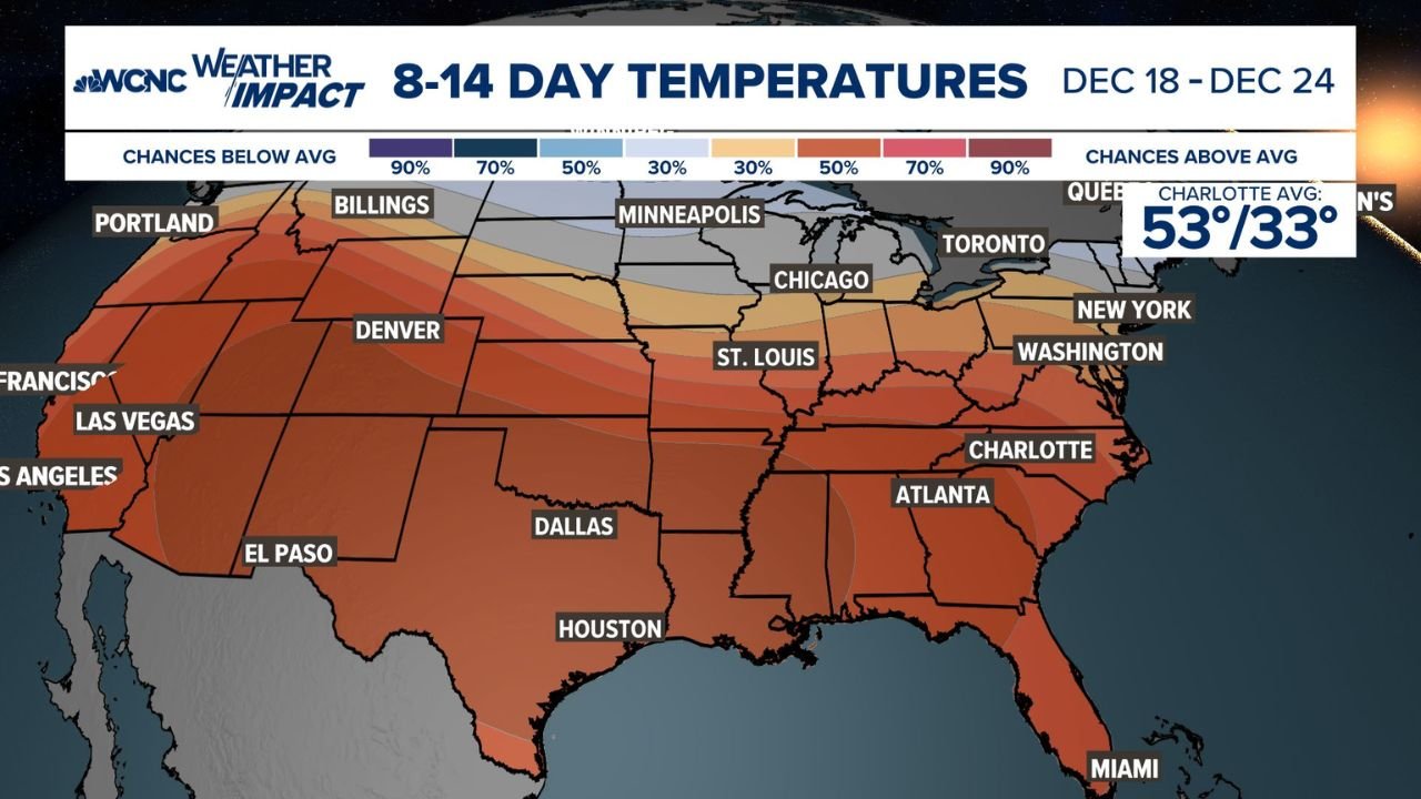
8–14 Day Outlook: Warm Signal Continues Into Christmas Week
The 8–14 day outlook (December 18–24) keeps the warm theme going.
The updated map shows strong probabilities for above-average temperatures over the Southeast, Mid-Atlantic, and much of the central and southern United States, including:
- North Carolina and South Carolina
- Georgia, Florida, Alabama and Mississippi
- Texas, Louisiana and Arkansas
- Large portions of the Ohio and Tennessee Valleys
Farther north, the warm signal weakens a bit, with Minnesota, the Dakotas and parts of the Upper Midwest closer to normal or even slightly cooler. But for holiday travelers across the Carolinas and much of the East, odds currently favor more rain and chilly breezes rather than deep winter cold.
Why the Pattern Is Flipping Warmer
This upcoming warm stretch is tied to a shift in the jet-stream pattern across North America.
Instead of a deep dip in the jet stream sending polar air straight into the central and eastern U.S., forecast models show a broad ridge of high pressure building over the southern and central states. That ridge tends to:
- Deflect Arctic cold northward into Canada
- Pull milder Pacific and Gulf air across the lower 48
- Suppress major storm systems that would normally drag colder air south
In simple terms, the storm track lifts north, and the Southeast sits on the warm side of the pattern, increasing the chances for above-normal temperatures and more rain than snow for areas that do see precipitation.
What It Means for Holiday Plans in the Carolinas and Beyond
For residents of North Carolina and South Carolina, this pattern flip means the week leading up to Christmas is more likely to feel like a cool fall stretch than a deep winter blast.
Key takeaways for the Carolinas and much of the South:
- Higher odds of daytime highs in the 50s and 60s, depending on elevation and local conditions
- Lower risk of impactful ice or snow through at least December 24
- Potential for wet, breezy systems to ride along the jet stream, bringing showers instead of wintry weather
Farther north – across the Midwest, Mid-Atlantic and Northeast – the warmth doesn’t guarantee a snow-free holiday, but it reduces the likelihood of widespread white-Christmas conditions outside of the higher elevations and traditional lake-effect zones.
Could the Pattern Turn Cold Again After Christmas?
Forecasters caution that this mild spell may not last into the New Year.
Some longer-range guidance hints that the jet stream could reconfigure once more around late December or early January, allowing colder Arctic air to push back into the central and eastern United States. That scenario is far from locked in, but it’s enough for meteorologists to keep an eye on the post-Christmas and early-January period for a potential return to more classic winter conditions.
Stay Updated With WaldronNews.com
Forecasts this far out can and do change, especially when we’re dealing with large-scale pattern flips. As new model runs arrive and confidence increases, we’ll have updated coverage on temperatures, rain and snow chances, and any signs of a colder turn to close out 2025.
Keep checking back with WaldronNews.com for the latest extended-forecast updates, local temperature trends, and travel impacts as we head toward Christmas and the start of 2026.