
North Carolina, Virginia, Tennessee, and South Carolina Face Potential Major Ice Storm as Long-Range Models Signal Dangerous Winter Threat
UNITED STATES — Long-range forecast data is raising early concerns about a potentially significant winter storm that could impact North Carolina, Virginia, Tennessee, and parts of South Carolina in early January, with some model guidance depicting a high-impact ice and mixed-precipitation event across the central and southern Appalachians and surrounding Piedmont regions.
While confidence remains low this far out, multiple long-range indicators suggest a pattern that could support freezing rain, sleet, and accumulating snow, especially if cold air locked in western Canada and Alaska is eventually able to press southward into the eastern United States.
Which Areas Appear Most Impacted Right Now
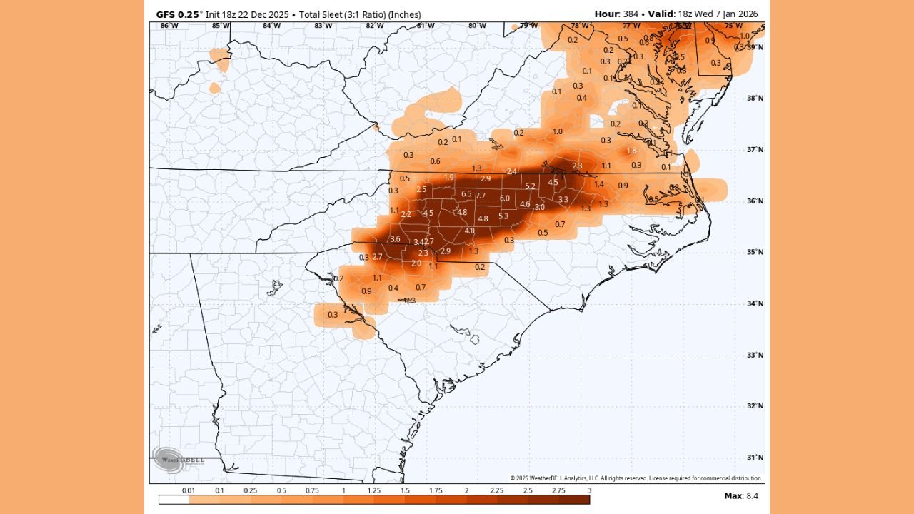
Based on the latest model visuals provided, the highest potential impact zone currently stretches from:
- Central and western North Carolina
- Southern and central Virginia
- Eastern Tennessee
- Upstate South Carolina
These areas repeatedly appear in the heaviest swaths of modeled freezing rain and sleet accumulation, with some extreme long-range simulations showing significant ice accretion exceeding one inch in parts of the interior Southeast — a scenario that would be highly disruptive if it were to materialize.
Lower but still notable winter weather signals also extend into northern Georgia and portions of West Virginia, mainly tied to sleet and snow on the colder side of the system.
Why This Pattern Is Being Watched Closely
Meteorologists are paying attention to the evolving large-scale atmospheric setup, which includes:
- A potentially active southern jet stream, capable of transporting moisture from the Gulf of Mexico.
- Cold air currently projected to remain bottled up in Alaska and western Canada, but with some long-range hints that it could eventually dive south.
- A possible negative Pacific-North American (-PNA) pattern combined with a near-neutral North Atlantic Oscillation (NAO), a configuration that can favor wintry setups in the Southeast under the right timing.
If cold air is able to phase with the southern stream system, the result could be prolonged freezing rain and sleet, particularly east of the Appalachian Mountains where shallow cold air can become trapped near the surface.
Potential Impacts If the Scenario Develops
Although this forecast is still speculative, impacts from an ice-dominant storm in the Southeast would be serious, including:
- Widespread power outages due to ice-laden trees and power lines
- Dangerous road conditions and major travel disruptions
- School and business closures across multiple states
- Tree damage and infrastructure stress in areas not accustomed to heavy ice
Even moderate ice accumulations can cause significant problems in this region, making early awareness important.
Important Uncertainty Remains
It is critical to emphasize that this potential storm is still well beyond the reliable forecast window. Forecast skill drops sharply beyond 7–10 days, and model solutions at this range often fluctuate dramatically from run to run.
At this stage, meteorologists are focusing on pattern recognition, not specific snowfall or ice totals. The atmospheric setup bears watching, but it could still evolve into a much milder or rain-dominant outcome.
What Happens Next
Forecast confidence will increase substantially once the system enters the medium-range window. Residents across North Carolina, Virginia, Tennessee, and South Carolina are encouraged to stay informed but avoid reacting to specific totals or extreme graphics shared this far in advance.
WaldronNews will continue to monitor the evolving pattern and provide updates as newer data brings clarity to whether this early-January winter threat becomes a real concern or fades with time.