
North Dakota and Minnesota Face Four Days of Snow and Wintery Mix From Tuesday Through Friday as Two Storm Systems Bring Continued Cold With Lows Dropping to 10 Degrees
GRAND FORKS, NORTH DAKOTA — Winter is not done with North Dakota and Minnesota. The National Weather Service Grand Forks office, issuing its forecast Monday March 30, 2026 at 3:59 PM, is tracking a multi-day stretch of snow, wintery mix and bitter cold that will affect the region from Tuesday through Friday — with not one but two separate storm systems bringing back-to-back snow chances and keeping temperatures well below normal across both states. Amounts remain uncertain and will depend heavily on the exact track of each system, but residents across North Dakota and Minnesota should prepare for a prolonged period of winter weather heading into the first week of April.
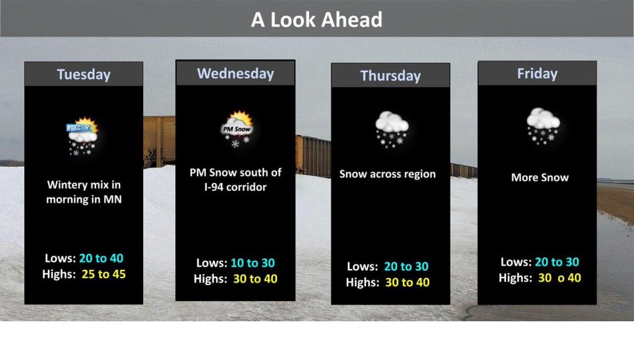
Day by Day Forecast — Tuesday Through Friday
Tuesday — Wintery Mix in Minnesota:
- Wintery mix in the morning across Minnesota — rain, freezing rain and snow possible depending on exact temperatures
- Lows: 20 to 40°F — a wide range reflecting uncertainty in how cold the air mass is across the region
- Highs: 25 to 45°F — staying well below average for this time of year
- The wintery mix threat is mainly focused on Minnesota Tuesday morning before conditions gradually improve through the day
Wednesday — PM Snow South of I-94 Corridor:
- PM snow developing south of the I-94 corridor across North Dakota and Minnesota — communities along and south of Interstate 94 including Fargo, Moorhead and Wahpeton are in the primary target zone for Wednesday’s snow
- Lows: 10 to 30°F — the coldest night of the four-day stretch, with lows potentially dropping to 10 degrees in the coldest spots
- Highs: 30 to 40°F — staying below freezing for much of the day
- This is the first of two systems — it arrives later in the day Wednesday, meaning roads could become snow-covered during the evening commute
Thursday — Snow Across the Region:
- Snow across the region — the most widespread snow day of the four-day stretch, with accumulation possible across both North Dakota and Minnesota
- Lows: 20 to 30°F
- Highs: 30 to 40°F — another day of below-freezing to barely above-freezing temperatures
- Snow totals for Thursday will depend heavily on how Wednesday’s system tracks and how much moisture remains available
Friday — More Snow From the Stronger System:
- More snow — a second and even stronger storm system arrives Friday, bringing continued snow chances into the weekend
- Lows: 20 to 30°F
- Highs: 30 to 40°F
- The stronger Friday system carries more uncertainty than the Wednesday event — amounts will vary significantly based on exact track and timing, but this system has the potential to produce meaningful accumulations across North Dakota and Minnesota
What This Means for Communities Across North Dakota and Minnesota
For residents of Fargo, North Dakota — you are directly in the path of Wednesday’s PM snow south of I-94 and Thursday’s broader regional snow. Wednesday evening travel could become hazardous as snow develops after the afternoon hours. Have winter supplies ready and allow extra time for the commute Wednesday evening.
For residents of Grand Forks, North Dakota — the I-94 corridor snow focus on Wednesday places you on the northern edge of the highest-impact zone for that system. Thursday and Friday’s broader snow chances are more directly relevant for Grand Forks and surrounding communities.
For residents of Minneapolis and the Twin Cities, Minnesota — Tuesday’s wintery mix is your most immediate concern, followed by Thursday and Friday snow chances. The I-94 corridor focus on Wednesday also puts portions of Minnesota in the Wednesday snow zone.
For residents of Moorhead, Wahpeton and communities along the North Dakota and Minnesota border — you sit squarely in the overlap zone for all four days of this winter weather stretch. From Tuesday’s wintery mix through Friday’s stronger system, this corridor faces the most consistent winter weather threat of the entire event.
Why Amounts Are So Uncertain
The NWS Grand Forks forecast is being careful to note that snow amounts are uncertain at this point and will depend on the exact track of each storm system. This is a very common and very honest caveat for storm systems at the 3 to 5 day range — small differences in where a storm tracks can mean the difference between a coating and 6 inches of snow for any given community. The Wednesday system is better defined at this range, while the Friday stronger system carries more uncertainty because it is further out in the forecast.
Residents should not fixate on specific snow totals right now — instead, focus on the fact that snow is likely across North Dakota and Minnesota on multiple days this week and plan accordingly.
What to Watch Next
- Tuesday morning wintery mix across Minnesota — whether freezing rain or snow dominates and which communities see the most significant impacts
- Wednesday evening I-94 corridor snow — updated accumulation forecasts as the system approaches
- Thursday regional snow totals — how much accumulates overnight Wednesday into Thursday morning across Fargo, Grand Forks and the Minnesota border communities
- Friday stronger system track — the most important forecast question of the week. Where exactly this system tracks will determine who gets significant snowfall
- NWS Grand Forks updates at weather.gov/gfg — check back frequently as forecast confidence improves heading into Wednesday
Residents across North Dakota and Minnesota — including Fargo, Grand Forks, Moorhead, Wahpeton and the Twin Cities metro — should have winter weather supplies stocked, vehicles winterized and plans in place for potentially hazardous road conditions on Wednesday evening, Thursday and Friday.
WaldronNews.com will continue tracking this multi-day winter weather event across North Dakota and Minnesota and provide updated snowfall totals and storm timing as forecast confidence improves.