
Northeast and Mid-Atlantic States Brace for Damaging Wind Gusts as Powerful Storm System Sweeps the Region
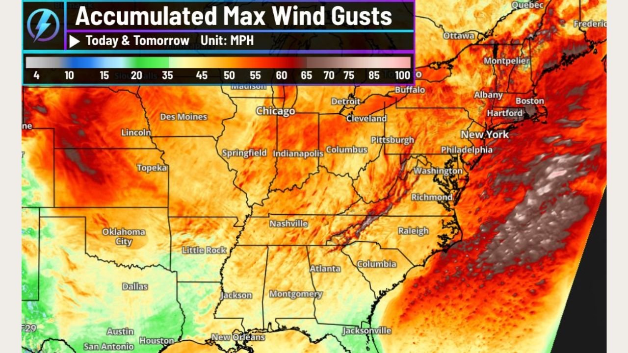
UNITED STATES — A large and intense storm system is producing widespread damaging wind gusts across much of the Central and Eastern United States, with impacts stretching from the Northern Plains to the Mid-Atlantic and Northeast. Forecast data shows wind gusts exceeding 35 mph across a massive portion of the country, with 70+ mph gusts already reported in the Northern Plains and near-hurricane-force winds possible along parts of the Northeast coastline late tonight into tomorrow.
Strong Winds Spreading Across the Central and Eastern U.S.
Weather data indicates that nearly all states east of the Rockies are experiencing elevated wind conditions as the powerful system advances eastward. Accumulated wind gust maps show broad areas of 35–50 mph gusts, which are strong enough to cause tree damage, power outages, and hazardous travel.
“This is a very widespread high-wind event, not confined to just one region,” meteorologists emphasized.
The strongest winds initially developed over the Northern Plains, where gusts up to and exceeding 70 mph were observed earlier in the day.
Mid-Atlantic and Northeast Face Increasing Wind Threat
As the storm system moves east, the Mid-Atlantic and Northeast are expected to see wind gusts of 40 to 50+ mph, with even stronger winds possible closer to the coast. Forecast guidance highlights the Northeast coastline and southern New England as areas where near-hurricane-force gusts could occur.
“The pressure gradient tightening along the East Coast may allow winds to briefly approach hurricane strength in exposed coastal areas,” forecasters warned.
Cities from Washington, D.C., and Philadelphia to New York City and Boston could experience power disruptions and travel delays, especially during the overnight hours.
Coastal and Marine Conditions Rapidly Deteriorating
Along the East Coast, strong onshore winds combined with high seas will likely lead to dangerous marine conditions, with rough surf and difficult navigation for smaller vessels. Coastal infrastructure may also be stressed by prolonged high winds.
Drivers on bridges and elevated roadways are urged to use caution, particularly those operating high-profile vehicles.
Why This Wind Event Is So Extensive
Meteorologists point to a strong storm system with an expansive wind field, allowing damaging winds to spread far from the storm’s center. Factors contributing to the severity include:
- A strong pressure gradient
- Fast storm motion
- Seasonal atmospheric dynamics that enhance surface wind transfer
“Even areas far from the storm’s core are experiencing impactful winds,” experts noted.
Safety Guidance as Winds Continue
Officials across impacted states advise residents to:
- Secure loose outdoor objects
- Avoid parking near trees and power lines
- Prepare for possible power outages
- Limit travel during peak wind periods
Wind conditions are expected to gradually ease after the system exits the East Coast, but lingering gusts may continue into tomorrow in some areas.
WaldronNews.com will continue monitoring this multi-state high-wind event and provide updates as the storm progresses across the Eastern United States.