
Northeast Braces for Dangerous Arctic Wind Chills to -40°F, With -50°F Possible at Hunter Mountain in New York
UNITED STATES — A true blast of Arctic air is tightening its grip on the Northeast, with wind chills forecast to plunge into the minus-30°F to minus-40°F range in parts of the region into Sunday, conditions that can turn dangerous quickly and may push toward record-low territory in some locations. The most extreme value highlighted in the latest outlook is at the top of Hunter Mountain in New York, where wind chills could bottom out near minus-50°F.
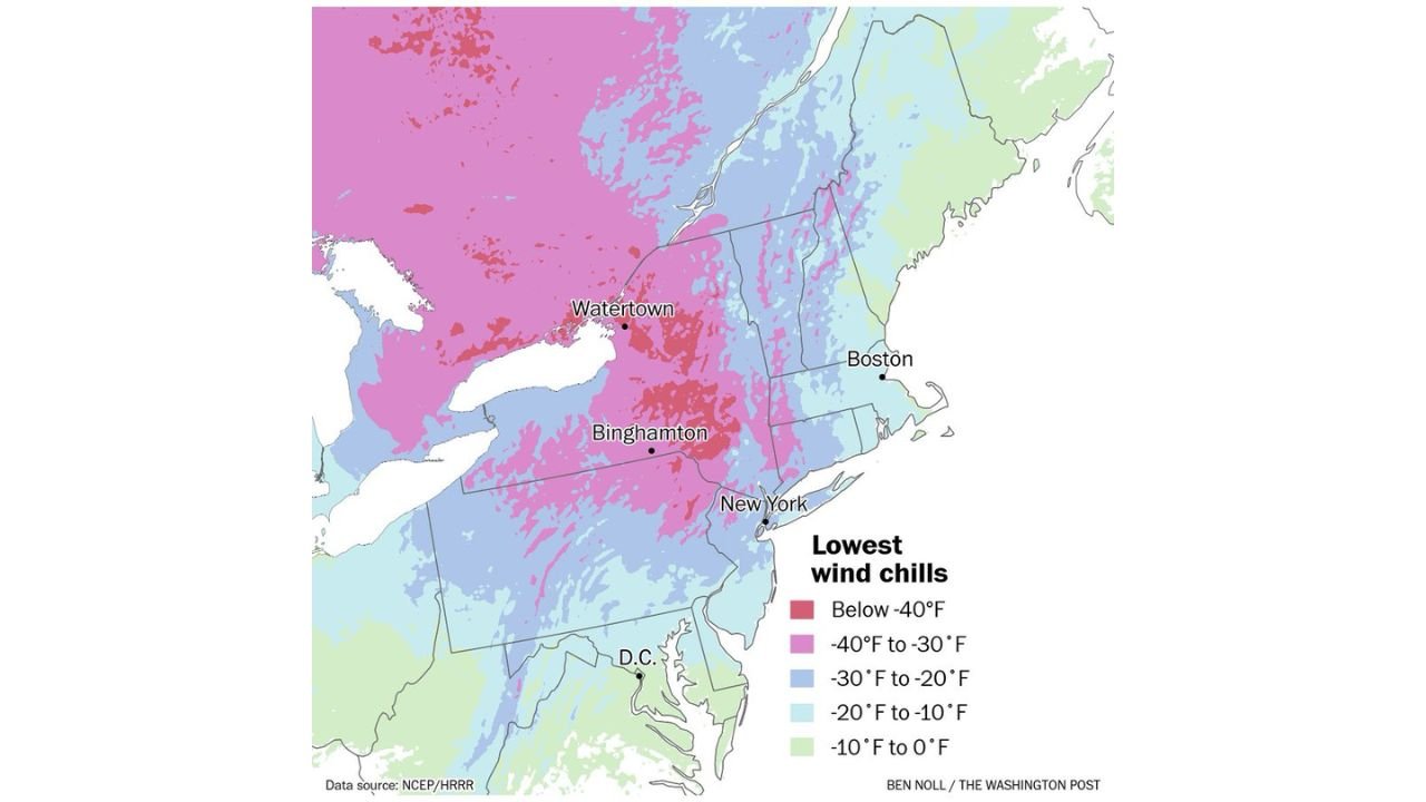
The wind chill map shows the harshest cold concentrating across portions of Upstate New York and interior areas of the Northeast, with frigid conditions extending toward major corridors that include areas near Watertown, Binghamton, New York City, and Boston, and reaching down toward the Mid-Atlantic near Washington, D.C. While the exact numbers will vary by elevation, wind exposure, and timing, the message is the same across the region: this is not just “cold,” it is dangerous cold.
What The Wind Chill Numbers Mean for Real Life
Wind chill is the “feels like” temperature your skin experiences when strong winds strip away your body heat faster than calm air would. When wind chills crash into the -30°F to -40°F range, exposed skin can become vulnerable to frostbite in a short period of time, especially on fingers, toes, ears, and nose.
For mountain locations and ridgelines—where winds are stronger and sustained—conditions can be even more punishing. That’s why the coldest projected value being tied to Hunter Mountain, New York is significant: higher elevations can hit extreme wind chills even when nearby valleys are slightly less severe.
Areas Most Likely to See the Worst of the Cold
Based on the footprint shown in the map, the coldest wind chills are most favored across:
- Upstate New York, including areas near and north of Watertown
- Interior sections of New York near Binghamton and higher terrain nearby
- Portions of New England, including inland zones that feed into the Boston region
- A broader corridor where “brutal” wind chills spread southward toward the Mid-Atlantic, including areas near Washington, D.C.
Even where the map shows less extreme shading near the coast and major cities, the cold still bites—especially during nighttime and early morning hours when temperatures typically bottom out.
Why This Cold Snap Could Approach Records
When wind chills are driven this low, it usually means two things are happening at the same time:
- Arctic air is already very cold, pushing actual temperatures down hard
- Winds remain strong enough to keep wind chill values far below the thermometer reading
That combination can produce conditions that feel historically severe, and in some areas may line up closely with prior extreme events—especially in elevated terrain and open, wind-prone locations. Even if official “record” air temperatures are not broken everywhere, the human impact can still match or exceed what people remember from major cold outbreaks.
What To Do Now
If you’re in the Northeast and this wind chill forecast overlaps your area, the safest plan is to treat it like a short-term hazard event.
If you must be outside:
- Limit exposure time and take frequent warm-up breaks indoors
- Wear multiple layers, including a wind-blocking outer layer
- Cover exposed skin: hat, face covering, gloves/mittens, and insulated boots
- Avoid sweating—wet clothing can make hypothermia risk climb faster
At home and on the road:
- Keep a fully charged phone and emergency supplies if traveling
- Check on elderly neighbors, anyone without reliable heat, and outdoor pets
- Make sure pets are indoors and water sources don’t freeze
- If you’re heading into higher elevations (ski areas, mountain roads), prepare for much harsher wind exposure
What Happens Next
This Arctic surge is expected to linger into Sunday, meaning the cold isn’t just a single overnight dip. The most intense wind chills often occur when the coldest air overlaps with peak wind, which can happen overnight, early morning, and in exposed terrain throughout the day.
If you’re planning weekend travel or outdoor activities anywhere from Upstate New York through interior New England and down toward the Mid-Atlantic, plan for rapidly changing comfort and safety conditions—especially in open areas, bridges, higher terrain, and places where the wind stays elevated.
WaldronNews.com will continue tracking the cold and any updates to the wind chill forecast. If you’re in the Northeast, what are you seeing where you live—do the conditions feel as severe as the forecast suggests? Share what you’re experiencing and keep following WaldronNews.com for the latest regional weather updates.