
Northeast Coastal Storm to Deliver 3–10 Inches of Snow Across Connecticut, Rhode Island, New Jersey, and Long Island; Heaviest Totals Expected Along the New York–Long Island Corridor
NORTHEASTERN UNITED STATES — A strengthening coastal winter storm is set to bring widespread, fast-accumulating snowfall across Connecticut, Rhode Island, New Jersey, and Long Island beginning late Sunday and continuing into Tuesday morning.
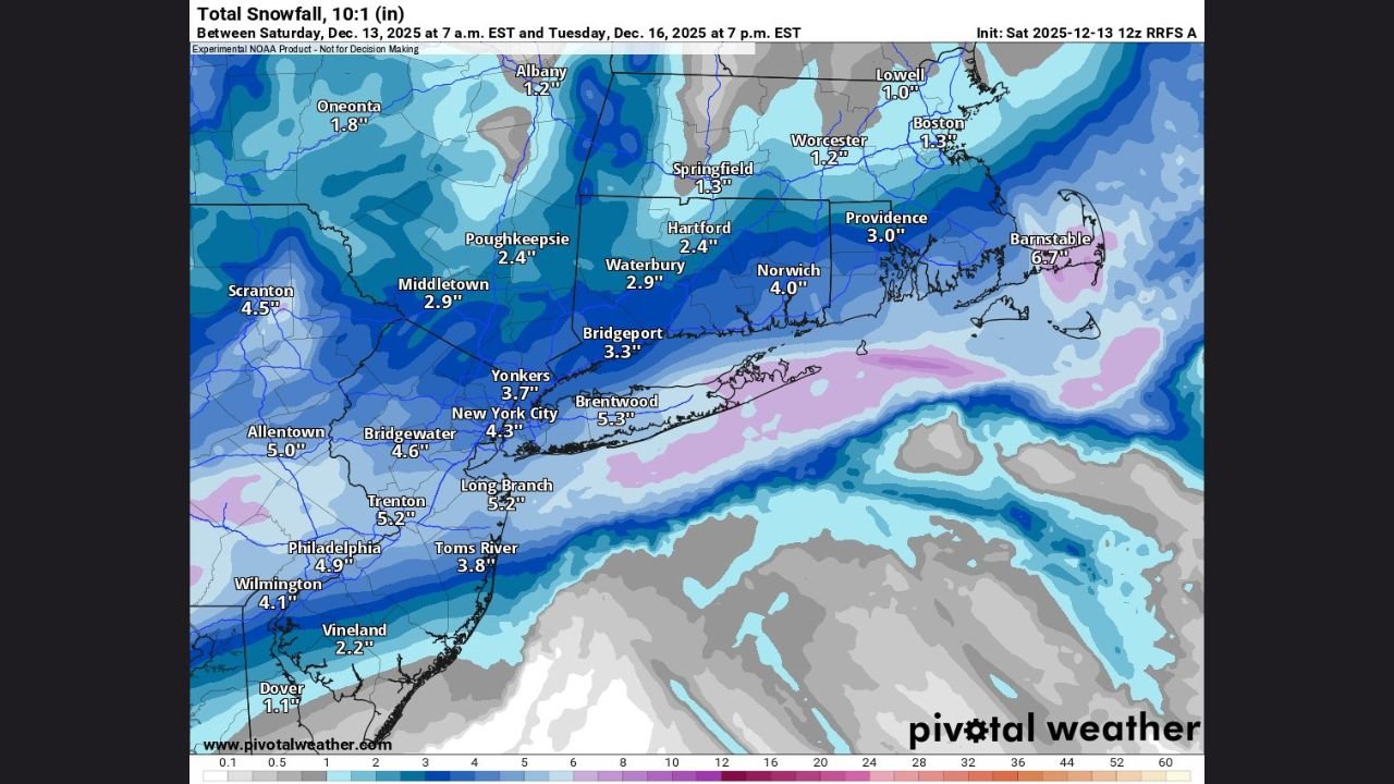
Forecast models show a sharp snow gradient across southern New England and the Tri-State area, with the most significant snowfall targeting Long Island and coastal New Jersey, where totals may push 6 to 10 inches, with isolated pockets even higher.
A Coastal Band of Heavy Snow Takes Aim at Long Island and New Jersey
Multiple models, including NOAA’s high-end probability projections and snowfall maps from Pivotal Weather, highlight a high-impact snow zone stretching from:
- New York City
- Across Long Island
- Into coastal and central New Jersey
Forecast totals in the core band include:
- Stony Brook (Long Island): 10″
- Islip: 9″
- Montauk: 8″
- New Brunswick, NJ: 8″
- Paramus, NJ: 7″
- Long Branch: 5.2″
- Trenton: 5.2″
Meteorologists note Long Island is positioned directly beneath the storm’s strongest moisture plume, increasing the potential for isolated 10″+ totals, particularly toward eastern Suffolk County and the Atlantic-facing coastline.
Connecticut and Rhode Island to See Moderate Snowfall: 3–6 Inches
While the heaviest totals remain south of the Connecticut and Rhode Island coasts, both states will still experience widespread accumulating snow.
Connecticut
- Hartford: 2.4″
- Waterbury: 2.9″
- Bridgeport: 3.3″
- Norwich: 4.0″
- New Haven region: 5–6″+ possible in stronger bands
Rhode Island
- Providence: 3.0″
- Coastal RI: 4–6″ possible
- Northern RI: 2–3″
As snow ratios rise to 15:1, even lighter precipitation may accumulate faster, especially overnight.
Why This Storm Will Produce Fluffy, Fast-Building Snow
Meteorologists highlight two primary reasons for rapid accumulation:
- Snow-to-liquid ratios will increase from 10:1 to around 15:1, producing smaller, lighter flakes that stick easily.
- Cold, entrenched air mass ensures snow begins accumulating immediately, even on pretreated surfaces.
This means accumulation rates could be deceptively fast, particularly after dark when surface temperatures drop.
Timing Across the Region
Across the four-state region, the storm will follow a similar timeline:
- Late Sunday: Snow begins across Long Island, New Jersey, Connecticut, and Rhode Island
- Overnight into Monday: Heaviest snowfall, especially in the NYC–Long Island–NJ corridor
- Monday afternoon: Lighter snow continues for parts of New England
- Tuesday morning: Final flurries taper off near Cape Cod and the Islands
Commuters can expect significant travel delays on Monday due to snow-covered roads and reduced visibility.
State-by-State Travel Impacts
New Jersey
- Hazardous travel along Garden State Parkway, I-78, I-80, and NJ Turnpike
- Coastal towns may see the quickest accumulation
Long Island
- Severe travel impacts along the Long Island Expressway (LIE) and Sunrise Highway
- Regional airports (JFK, LaGuardia, Islip) may face delays or cancellations
Connecticut
- Slick conditions on I-95, Route 15, and I-84, especially overnight
- Bridgeport and coastal CT may see faster accumulation than northern counties
Rhode Island
- Potential disruptions for commuters near Providence and Cranston
- Coastal snow may accumulate rapidly with higher moisture availability
A Significant Early-Season Storm for the Northeast
This storm will mark the first widespread, high-impact snowfall event of the 2025–2026 winter season for millions across southern New England and the Tri-State area.
Long Island and central New Jersey stand out as the most at-risk regions, with high-end model guidance showing a 10% chance of snowfall exceeding 10 inches.
WaldronNews.com will continue tracking updated snowfall guidance, National Weather Service alerts, and regional impacts as the storm evolves.