
Northeast Cold Wave Targets New York, Massachusetts, Connecticut, Vermont, and Maine With Dangerous Wind Chills This Weekend
UNITED STATES — A powerful blast of Arctic air is set to grip the Northeast this weekend, bringing what forecasters say could be the coldest stretch of the season for large parts of New York, Massachusetts, Connecticut, Vermont, New Hampshire, and Maine, with dangerous wind chills and the potential for ocean-effect snow.
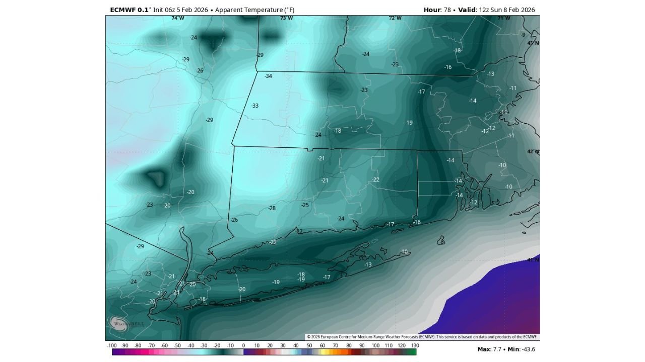
Forecast data shows temperatures and wind chills plunging well below seasonal averages, with the most severe conditions expected Saturday night into Sunday morning.
Bitter Cold Could Make Sunday the Coldest Day of the Season
Model guidance indicates that Sunday is a strong contender for the coldest day of the winter so far across the Northeast.
Actual air temperatures are expected to run 20 to 30 degrees below average, while feels-like temperatures (wind chills) drop sharply due to persistent winds. Wind chill values of -15°F to -30°F are forecast across interior portions of New York, Vermont, New Hampshire, and Maine, with sub-zero readings extending into southern New England.
Coastal areas of Massachusetts and Connecticut may see slightly higher actual temperatures, but wind exposure will still drive wind chills into the teens below zero at times.
Saturday Night and Sunday Morning Expected to Be the Most Dangerous Period
The coldest window appears to be late Saturday night through early Sunday morning, when Arctic air fully settles over the region.
Forecast apparent temperature maps show widespread negative teens and twenties, even near the coast. Inland valleys and elevated terrain are expected to experience the harshest conditions, with prolonged exposure posing a serious risk of frostbite and hypothermia.
Forecasters note that while this is a quick-hitting cold blast, its intensity makes Sunday morning particularly difficult for anyone outdoors.
Ocean-Effect Snow Possible Friday Into Saturday in New England
In addition to the cold, high-resolution NAM guidance is picking up on ocean-effect snow potential on Friday into Saturday, especially across eastern New England.
A north-northeast (NNE) flow off the Atlantic will push moisture inland into very cold air, supporting scattered snow showers across parts of eastern Massachusetts, coastal New Hampshire, and Maine. Snow totals appear generally light at this stage, but localized higher amounts are possible where bands persist.
Snow chances may linger into Saturday before tapering off as colder, drier air fully takes over.
Conditions Improve After Sunday as Cold Quickly Retreats
Despite the severity of the cold, forecast guidance suggests the Arctic air mass will move out quickly after Sunday.
Temperatures are expected to moderate early next week, allowing wind chills to recover and ending the most dangerous cold conditions. However, forecasters caution that Saturday night and Sunday morning remain the primary concern, especially for travel, outdoor work, and vulnerable populations.
Stay with WaldronNews.com for continued updates on this developing winter weather threat, including cold safety guidance and localized impacts as the weekend approaches. If you’re experiencing extreme conditions where you live, share your reports and photos with us.