
Northeast Winter Storm Expected to Bring Heavy Snow, Ice, and Sharp Cutoff Zones Across Pennsylvania, New York, New Jersey, and New England
ILLINOIS —A strengthening winter storm is expected to impact a wide portion of the Northeastern United States from Friday, December 26, into early Saturday, December 27, bringing a complex mix of heavy snow, sleet, and freezing rain that could significantly disrupt post-Christmas travel across Pennsylvania, New York, New Jersey, and parts of New England.
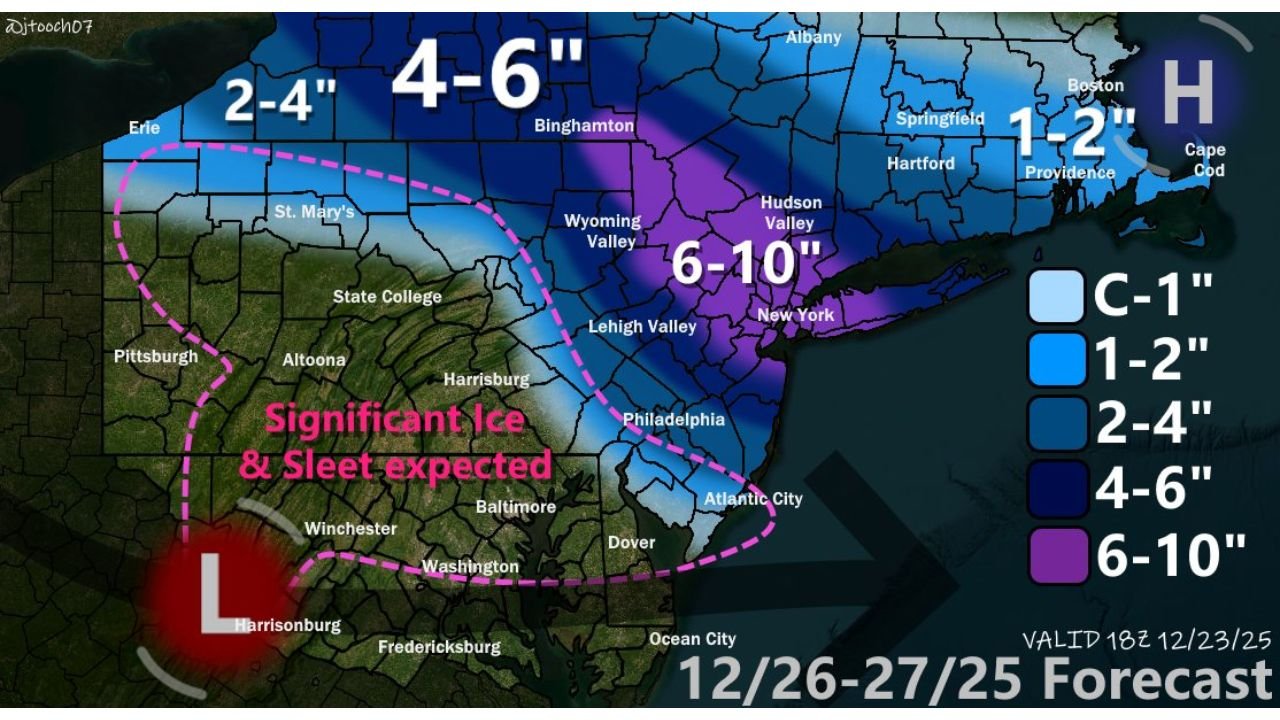
Meteorological data indicates a low-pressure system diving southeast from Canada and the Upper Midwest, interacting with a strong high-pressure system over Quebec that is supplying deep cold air into the region. This setup is favorable for widespread winter precipitation, with sharp gradients expected between snow-dominant and ice-dominant zones.
Storm Setup And Timing
Forecast guidance shows precipitation developing Friday morning across Pennsylvania, spreading eastward through New Jersey and New York by Friday evening, and reaching southern New England overnight. The system is expected to taper off Saturday morning, though lingering icy conditions may persist into midday.
A warm layer of air aloft — often referred to as a “warm nose” around 750 mb — will play a critical role in determining precipitation type, especially across interior regions.
Ice And Sleet Likely In Central Pennsylvania And Northern Maryland
The highest risk for ice and sleet accumulation is expected across central Pennsylvania and northern Maryland, where surface temperatures remain below freezing while warmer air overruns from above.
These areas are unlikely to see significant snowfall, instead facing the potential for:
- Slick road conditions
- Isolated power outages
- Hazardous travel due to freezing rain and sleet accumulation
Even small ice amounts could create outsized impacts, particularly overnight and during early-morning travel.
Heavy Snow Expected From Northeastern Pennsylvania Into New York And Northern New Jersey
Forecast models show the most favorable setup for heavy snowfall across:
- Northeastern Pennsylvania
- The New York City metro area
- Northern New Jersey
- Long Island
Snowfall rates could exceed 1–2 inches per hour at times, with the possibility of thundersnow in localized bands as strong lift and frontogenesis develop.
These areas are currently within the corridor most likely to see widespread plowable snow, with travel disruptions expected late Friday into early Saturday.
Sharp Snow Cutoff Zone Across Eastern Pennsylvania
One of the most challenging aspects of this forecast is the extremely tight gradient expected across eastern Pennsylvania, including:
- The Lehigh Valley
- Northern portions of the Philadelphia metro area
Forecast guidance suggests that snow totals could vary dramatically over short distances. Some locations may receive 6 inches or more, while areas just 10–15 miles west could see half that amount or less, with sleet mixed in.
Residents are advised to monitor updates closely, as small shifts in storm track could significantly change local outcomes.
Snow Band Possible Along Coastal Massachusetts
Additional model guidance supports the potential for a narrow but impactful snow band across eastern and southeastern Massachusetts, driven by a Norlun-type coastal feature. Colder air arriving ahead of the system increases the chance that snow could coat roadways, particularly near the coast.
While accumulations remain uncertain, localized impacts are possible, especially during overnight hours.
Travel Impacts Expected Ahead Of The Weekend
With the storm occurring during one of the busiest travel periods of the holiday season, conditions may deteriorate rapidly across major interstates, airports, and rail corridors.
Drivers should be prepared for:
- Rapidly changing road conditions
- Reduced visibility during heavier snowfall bands
- Ice-covered surfaces in interior regions
Further forecast refinements are expected as higher-resolution data becomes available.
What To Watch Next
Meteorologists expect additional updates, including city-specific snowfall projections and refined accumulation maps, as the storm approaches. Small changes in temperature profiles or storm track could still shift the heaviest impacts.
WaldronNews.com will continue tracking this developing winter storm and provide updated forecasts, impact summaries, and travel guidance as new data becomes available. Share your local conditions and stay connected with us for the latest weather updates across the region.