
Northern California and the Sierra Nevada Face Up to 2 Inches of Rain and 6 to 21 Inches of Snow Above 8000 Feet by Thursday Morning as Models Trend Wetter
SACRAMENTO, CALIFORNIA — Models have been trending progressively wetter for Northern California and the Sierra Nevada heading into midweek, with the latest WPC 2.5 km precipitation forecast — initialized March 31, 2026 at 12Z and valid through Thursday April 2 at 18Z — showing up to 2 inches of liquid precipitation near the mountain crests by Thursday morning. Snow levels will fluctuate mostly between 7,000 and 8,000 feet throughout the event before dropping below 6,000 feet Wednesday night — bringing wet snow down to lower mountain elevations and delivering a meaningful late-season snowpack boost to the Sierra Nevada at a time when California’s water supply needs every inch it can get.
For the lower mountain zones, a coating up to several inches of wet snow is expected. For elevations above 8,000 feet, accumulations of 6 to 21 inches of snow are forecast — a wide range that reflects ongoing uncertainty in exact storm track and intensity, but one that clearly signals significant snowfall for the high Sierra.
Where the Heaviest Precipitation Falls
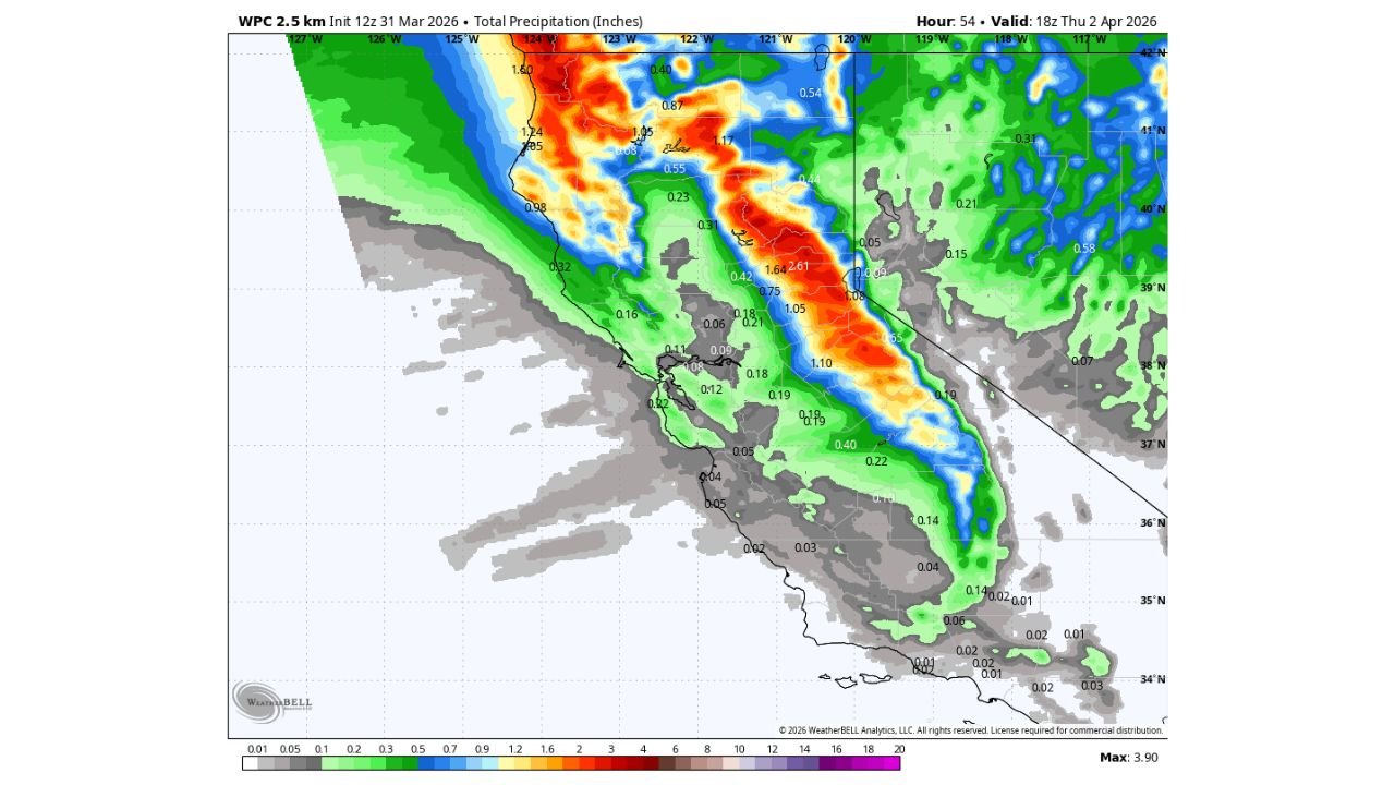
The WPC precipitation map shows the highest liquid totals concentrated along the northern Sierra Nevada and the coastal ranges of Northern California:
Highest totals — northern Sierra crest and northern California ranges:
- Northern Sierra Nevada crest area — up to 2.61 inches of liquid precipitation in the highest concentration zones
- Northern California coastal ranges — 1.60 to 1.74 inches along the northern coastal mountain corridors
- Central Sierra corridor — 1.05 to 1.64 inches across the higher terrain
- Northern California interior ranges — 0.87 to 1.05 inches in the northern corridors
Moderate totals — central California mountain zones:
- Central Sierra foothills — 0.40 to 0.75 inches across lower elevation mountain areas
- Lake Tahoe region — within the moderate precipitation corridor, with significant snow above 7,000 to 8,000 feet
- Northern Sacramento Valley fringe — 0.23 to 0.55 inches on the valley edges where terrain forces moisture upward
Lighter totals — Bay Area and Central California:
- San Francisco Bay Area — 0.09 to 0.18 inches — light rain for the metro area
- Central Valley — very light to trace amounts across the flat valley floor
- Southern California — minimal moisture reaching the southernmost portions of the state
Snow Level Forecast — What It Means for the Sierra
The fluctuating snow level is one of the most important details of this storm for mountain communities and travelers:
Wednesday — snow levels remain mostly between 7,000 and 8,000 feet. Above these elevations, snow accumulates steadily throughout the day. Below these levels, precipitation falls primarily as rain even in mountain communities.
Wednesday night — snow levels drop below 6,000 feet. This is when mountain communities at mid-elevations begin seeing snow accumulation. Communities and highway passes that had been receiving rain will transition to snow as temperatures fall and the cold air pushes the snow level down.
For mountain passes and highways across the northern Sierra — including Highway 50, Interstate 80 and Highway 88 — the Wednesday night snow level drop below 6,000 feet is the critical timing detail for travel planning. Anyone who needs to cross Sierra Nevada passes Wednesday night should either complete their crossing before the snow level drops or plan to wait until Thursday when conditions improve.
What 6 to 21 Inches Above 8,000 Feet Means for California’s Water Supply
California has been in a historically dry pattern through March 2026, and the arrival of meaningful late-season Sierra snowpack is significant for the state’s water supply outlook. The Sierra Nevada snowpack is the single most important water storage mechanism for California — storing winter precipitation as snow and releasing it gradually through the spring and summer as melt water that feeds rivers, reservoirs and agriculture across the state.
Even a 6 to 21 inch snowfall above 8,000 feet in early April — while it will not single-handedly resolve California’s drought concerns — represents a meaningful addition to the snowpack at exactly the time of year when every additional inch of water equivalent stored in the mountains translates directly to water supply later in the spring and summer.
For ski resorts and mountain recreation areas across the northern and central Sierra — this storm is also a late-season lifeline, potentially allowing extended operations beyond what the dry and warm March had suggested was possible.
What to Watch Next
- Wednesday evening snow level drop — when exactly snow levels fall below 6,000 feet and which highway passes begin accumulating snow
- Sierra crest accumulation totals — whether the upper end of the 6 to 21 inch range is realized at the highest elevations
- Highway conditions on Interstate 80, Highway 50 and US-395 Wednesday night into Thursday
- Caltrans chain control requirements — watch for chain requirements to be implemented across Sierra Nevada passes Wednesday evening
- Reservoir inflow — whether the combined rain and snowmelt from this storm produces measurable inflow into Folsom Lake, Shasta Lake and other Northern California reservoirs
- Model trends — whether the wetter trend continues in subsequent forecast runs, potentially pushing totals even higher than currently shown
Residents and travelers planning to cross Sierra Nevada mountain passes on Wednesday evening or Thursday should check Caltrans road conditions at quickmap.dot.ca.gov before departing and carry chains or have all-wheel drive with adequate winter tires.
WaldronNews.com will continue tracking this Northern California and Sierra Nevada storm system and provide updated snowfall totals and road condition information as the event develops through Thursday.