
Northern Illinois Flagged for Explosive Severe Weather Tuesday as Dangerous 68 Degree Dewpoints and All Hazards Tornado Environment Lock in Across the Chicago Corridor
CHICAGO, Illinois — Northern Illinois is being flagged as a serious severe weather target for Tuesday, April 14, as an extraordinarily rich and dangerous thermodynamic environment takes shape across the region — with surface dewpoints reaching 68°F to 69°F across northern Illinois and the broader Great Lakes corridor, a TOR — tornado — hazard designation confirmed in the atmospheric sounding, and all severe weather hazards simultaneously on the table for communities stretching from northern Illinois through Indiana and into the Great Lakes.
Two critical uncertainties remain heading into Tuesday — a warm nose at the surface and lacking low-level shear could complicate storm organization — but the sheer thermodynamic energy present in Tuesday’s atmosphere across northern Illinois is so extreme that even a partially favorable storm mode produces a serious and dangerous severe weather outcome.
What the Atmosphere Is Showing for Northern Illinois Tuesday
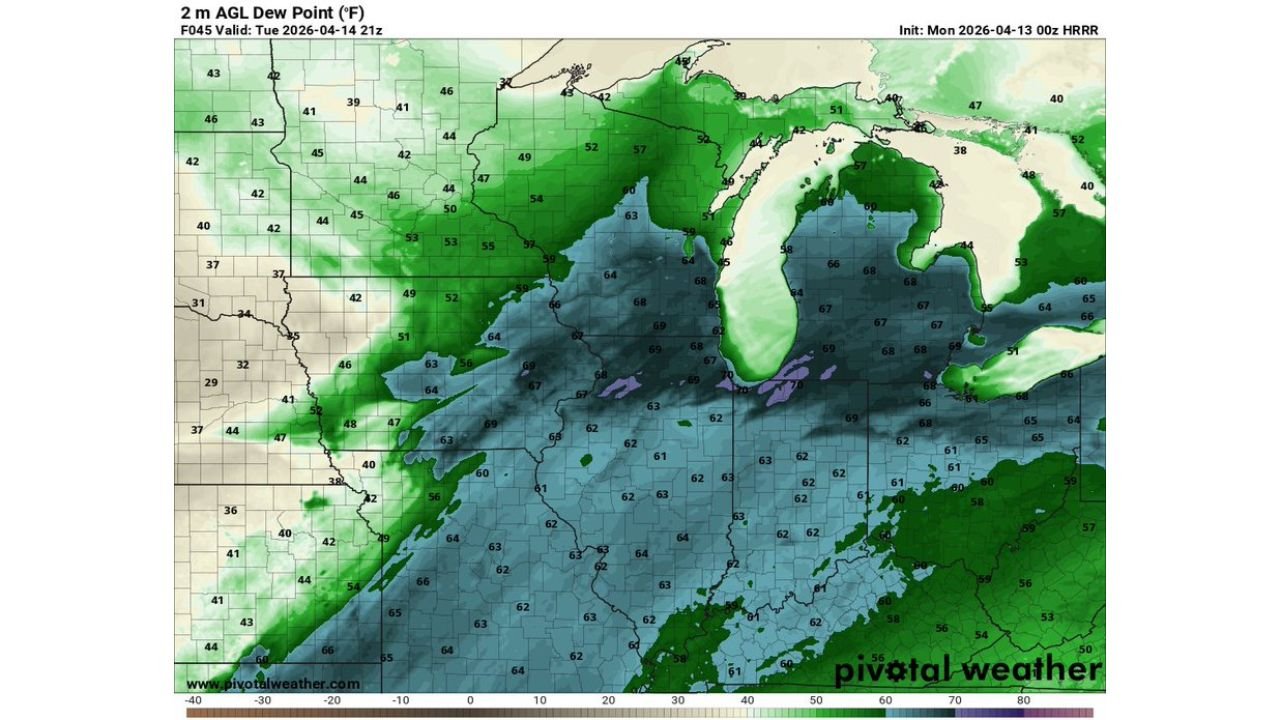
Dewpoints — Historically Rich Moisture for April: The 2-meter dewpoint map valid Tuesday, April 14 at 9:00 PM CDT reveals one of the most striking moisture signatures seen this far north this early in the spring season. Surface dewpoints across northern Illinois and the Indiana border region are running at 63°F to 69°F — with a concentrated zone of 68°F to 69°F dewpoints sitting directly over the northern Illinois corridor. These are not typical April moisture values for this latitude — dewpoints in the upper 60s in mid-April across northern Illinois represent an exceptionally deep and anomalous surge of Gulf moisture that has pushed far further north than is normally seen this time of year.
To put this in perspective — dewpoints of 68°F to 69°F are values more commonly associated with mid-July heat and humidity across the Deep South. Having this level of moisture in place across northern Illinois in April creates an atmosphere loaded with latent energy that any developing storm can immediately tap into, producing explosive growth, intense updrafts, and dangerous hail and wind production.
Atmospheric Sounding — TOR Environment Confirmed: The atmospheric sounding for Tuesday, April 14 at 11:00 PM CDT near the northern Illinois corridor tells an alarming story about Tuesday’s severe weather potential. Key values from this sounding include:
- Surface CAPE of 1,006 J/kg with a FCST CAPE of 1,641 J/kg — confirming significant instability available for storm development even accounting for atmospheric limitations
- SigSvr parameter of 75,306 m³/s³ — an extraordinarily high value that combines multiple severe weather ingredients into a single number, indicating an environment strongly supportive of significant severe weather
- SRH of 223 m²/s² at the 0-3km layer — providing meaningful rotational support for supercell development
- Effective Shear of 45 m²/s² — sufficient to support organized, long-lived storm structures
- Psbl Haz. Type: TOR — the atmospheric profile is classified as a tornado environment, confirming that rotating storm and tornado production is the primary hazard type for Tuesday’s setup
- Supercell composite of 17.0 — an extremely high value indicating the atmosphere strongly favors supercell thunderstorm development
- STP of 2.6 — well above the critical 1.0 threshold associated with significant tornado production, placing Tuesday’s northern Illinois environment firmly in dangerous tornado territory
- Surface dewpoint of 68°F confirmed at the sounding level — matching the broader regional moisture analysis
The Two Uncertainties That Could Limit Tuesday’s Threat
Despite the alarming thermodynamic data, two specific atmospheric factors are creating forecast uncertainty for northern Illinois Tuesday:
Warm Nose at the Surface: A warm nose — a layer of warmer air sitting above the surface but below the main storm environment — can act as a cap that suppresses storm development or prevents storms from fully accessing the rich instability below. If this warm nose is strong enough Tuesday, storms may struggle to initiate or may be less organized than the raw instability numbers suggest. This is the primary limiting factor that forecasters are watching closely heading into Tuesday.
Lacking Low-Level Shear: While the overall wind shear environment is sufficient for supercell development, the low-level shear — the change in wind direction and speed in the lowest kilometer of the atmosphere — is not as impressive as it would be in a classic Plains tornado outbreak. Low-level shear is the ingredient most directly responsible for the violent, ground-scraping rotation that produces the most dangerous tornadoes. Weaker low-level shear reduces — but does not eliminate — the tornado threat, and shifts the primary concern more toward large hail and damaging winds even if supercells do develop.
These two factors will be ironed out in the coming hours as higher-resolution forecast data becomes available — and the resolution of these questions will determine whether Tuesday’s northern Illinois threat is a moderate or major severe weather event.
Why Northern Illinois Cannot Ignore Tuesday Despite the Uncertainties
The combination of surface dewpoints at 68°F to 69°F, a TOR-classified sounding, a Supercell composite of 17.0, and an STP of 2.6 represents an atmospheric environment with extreme latent potential. Even accounting for the warm nose and low-level shear concerns, these numbers indicate an atmosphere that is primed to produce dangerous storms if the limiting factors relax even partially.
The SigSvr value of 75,306 m³/s³ is particularly striking — this parameter combines CAPE, shear, and other ingredients in a way that specifically identifies environments capable of producing significant severe weather. Values this high across northern Illinois in April are exceptional and demand serious attention regardless of the forecast uncertainties.
For communities across northern Illinois including Chicago, Rockford, Aurora, Joliet, and the broader metro area, Tuesday is not a day to dismiss simply because forecasters have questions about storm initiation and organization. The raw ingredients in place are dangerous, and if storms do develop and tap into the 68°F dewpoint environment beneath them, they will intensify rapidly and produce significant hazards.
Communities to Watch Tuesday Across Illinois and Indiana
- Northern Illinois: Chicago, Rockford, Aurora, Joliet, Waukegan, Elgin, and the entire northern Illinois corridor sit inside the highest dewpoint and instability zone identified for Tuesday
- Indiana: Fort Wayne, South Bend, and northwestern Indiana communities fall within the dangerous moisture corridor extending east from northern Illinois
- Wisconsin border zone: Communities along the Illinois-Wisconsin border sit at the northern edge of the most anomalous dewpoint values
- Central Illinois: Springfield and Peoria are within the broader severe weather environment though the highest moisture values are concentrated further north
What Northern Illinois Residents Need to Do Before Tuesday
- Monitor NWS Chicago forecast discussions Monday evening and Tuesday morning — the warm nose and low-level shear questions will be resolved in these updates and will clarify exactly how serious Tuesday’s threat becomes
- Despite the uncertainties, all severe weather hazards remain on the table — hail, damaging winds, and tornadoes are all possible if storms develop in this environment
- Every resident in northern Illinois should have a confirmed shelter plan and active weather alerts on all devices before Tuesday afternoon
- Vehicles across Chicago, Rockford, and the northern Illinois corridor should be under cover Tuesday — the instability and moisture in place Tuesday is more than sufficient to produce large, damaging hail even in a less-than-perfect storm mode
- Watch for SPC watches to be issued Tuesday morning — given the TOR sounding classification and extreme instability, watches covering northern Illinois are likely if storm initiation looks probable
- The Tuesday evening hours — when the sounding data is valid — represent the peak risk window for northern Illinois communities
Tuesday’s atmosphere over northern Illinois is loaded with some of the most anomalous April moisture and instability values seen in this region in years. The uncertainties are real, but so is the danger. Every resident across Chicago, Rockford, and the northern Illinois corridor needs to be weather-ready before Tuesday afternoon arrives.
WaldronNews.com will continue tracking Tuesday’s severe weather threat across northern Illinois and Indiana and will provide updates as forecast confidence on storm initiation and organization increases through Monday evening and Tuesday morning.