
Northern Illinois Snow Forecast Scaled Back: Chicago Area Now Looking at Dusting to 2 Inches Wednesday Night Before Quick Friday Melt
NORTHERN ILLINOIS — A winter system once expected to bring more widespread accumulation has weakened significantly over the past 24 hours, with updated projections now showing lighter snowfall totals across northern Illinois Wednesday night into Thursday morning.
While accumulating snow remains possible, overall amounts are now expected to stay on the low end — generally ranging from a dusting up to 2 inches, with most areas likely closer to the lower side of that range.
Noticeable Weakening in Snow Potential
Forecast guidance shows a clear reduction in both coverage and intensity of snowfall compared to earlier projections.
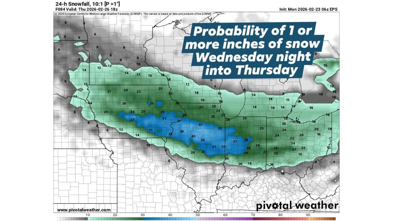
Probability data for at least 1 inch of snow now shows:
- Roughly 25% to 35% chances across central portions of northern Illinois
- Higher probabilities, near 35% to 43%, focused mainly south of the Wisconsin border and into north-central Illinois
- Lower confidence farther north toward Wisconsin
This indicates that while snow is still possible, widespread higher-end totals are no longer supported by current modeling.
Chicago Metro: Light Accumulation at Best
Across the Chicago metro area — including Cook, DuPage, Lake, Kane, and Will counties — snowfall totals are expected to be modest.
Most locations are projected to see:
- A light dusting to around 1 inch
- Isolated spots potentially approaching 2 inches
Given the weakening trend, several neighborhoods may end up on the lower side of these estimates.
Southern Edge of Snow Band
The strongest probabilities appear slightly south of Chicago, extending into parts of:
- Central Illinois
- Northern Indiana
Even in these areas, totals remain modest, with no significant winter impacts currently expected.
The snow band itself looks narrower and less organized than previously anticipated, which supports the reduced totals.
Quick Melt Expected Friday
Whatever snow does accumulate is not expected to stick around for long.
Temperatures on Friday are forecast to rise enough to promote melting, meaning any light coating from Thursday morning will likely disappear quickly.
This limits longer-term travel impacts and reduces the chance of lingering icy conditions.
Bottom Line
The midweek snow system across northern Illinois has weakened noticeably, trimming expected totals to a dusting up to 2 inches, with most areas leaning toward the lower end.
Chicago and surrounding suburbs may see some light accumulation Wednesday night into early Thursday, but impacts should be limited — and most of it will melt by Friday.
WaldronNews.com will continue monitoring updates if any further adjustments are made.