
Northern Ohio Including Cleveland, Toledo and Akron Under Enhanced Risk With Tornadoes, Large Hail and Flooding Threat Thursday Evening
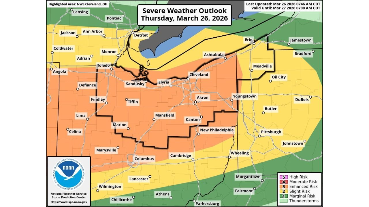
NORTHERN OHIO — A high-impact severe weather event is expected Thursday afternoon into the evening, with much of northern Ohio, including Cleveland, Toledo, and Akron, under an Enhanced Risk (Level 3 of 5) for dangerous storms.
Enhanced Risk Covers Cleveland, Toledo and Akron
The core threat area includes Cleveland, Toledo, Akron, Sandusky, Elyria, and surrounding communities, where conditions are favorable for strong to severe thunderstorms to develop later in the day.
This enhanced risk zone highlights an increased likelihood of widespread severe weather, with storms expected to intensify as they move through the region.
Nearby areas, including Columbus, Youngstown, and parts of western Pennsylvania, may also see strong storms, though the highest threat remains focused across northern Ohio.
Tornado and Large Hail Threat Increasing
Storms developing within this environment could produce isolated tornadoes, particularly during the evening hours when atmospheric conditions become more supportive of rotation.
In addition, there is a growing concern for large hail, potentially reaching or exceeding golf ball size, which could cause damage to vehicles, roofs, and property.
These threats indicate a volatile setup capable of producing rapidly intensifying storms across the region.
Damaging Winds Up to 70 MPH Possible
Another major concern is damaging straight-line winds, with gusts potentially reaching up to 70 mph in the strongest storms.
These winds could lead to downed trees, scattered power outages, and structural damage, especially in areas directly impacted by the most intense storm cells.
Travel could become hazardous as storms move through during the evening commute hours.
Heavy Rainfall Raises Flooding Concerns
Alongside severe weather, heavy rainfall is expected to accompany these storms, increasing the risk of localized flooding.
Urban areas such as Cleveland and Akron may be particularly vulnerable, where runoff can accumulate quickly during intense downpours.
Repeated rounds of storms or slow-moving cells could worsen flooding potential into the night.
Peak Timing Between Late Afternoon and Night
The most active window for severe weather is expected between late afternoon and around 5 PM to 10 PM, when storms are likely to be at their strongest.
This timing increases the potential for rapidly changing and dangerous conditions, especially as visibility drops and storms intensify after sunset.
Residents should remain alert and be prepared to act quickly if warnings are issued.
A Dangerous Evening Ahead for Northern Ohio
This setup reflects a classic severe weather pattern, where warm, unstable air interacts with an approaching system, leading to multiple hazards in a concentrated area.
With tornadoes, large hail, damaging winds, and flooding rain all possible, this could become a dangerous weather event for northern Ohio communities.
Residents across Cleveland, Toledo, Akron, and surrounding areas are urged to stay weather-aware, prepare now, and monitor alerts closely as storms approach.
Residents are encouraged to share conditions in their area and stay updated with the latest reports on Waldronnews.com.