
Oakland, Cumberland, Romney, and Areas Along the Allegheny Front Brace for 2–3 Inches of Mountain Snow Tuesday Afternoon
UNITED STATES — A round of accumulating mountain snow is expected to develop Tuesday afternoon across portions of the central Appalachians, with the highest impacts focused along and west of the Allegheny Front, according to the National Weather Service Baltimore/Washington office.
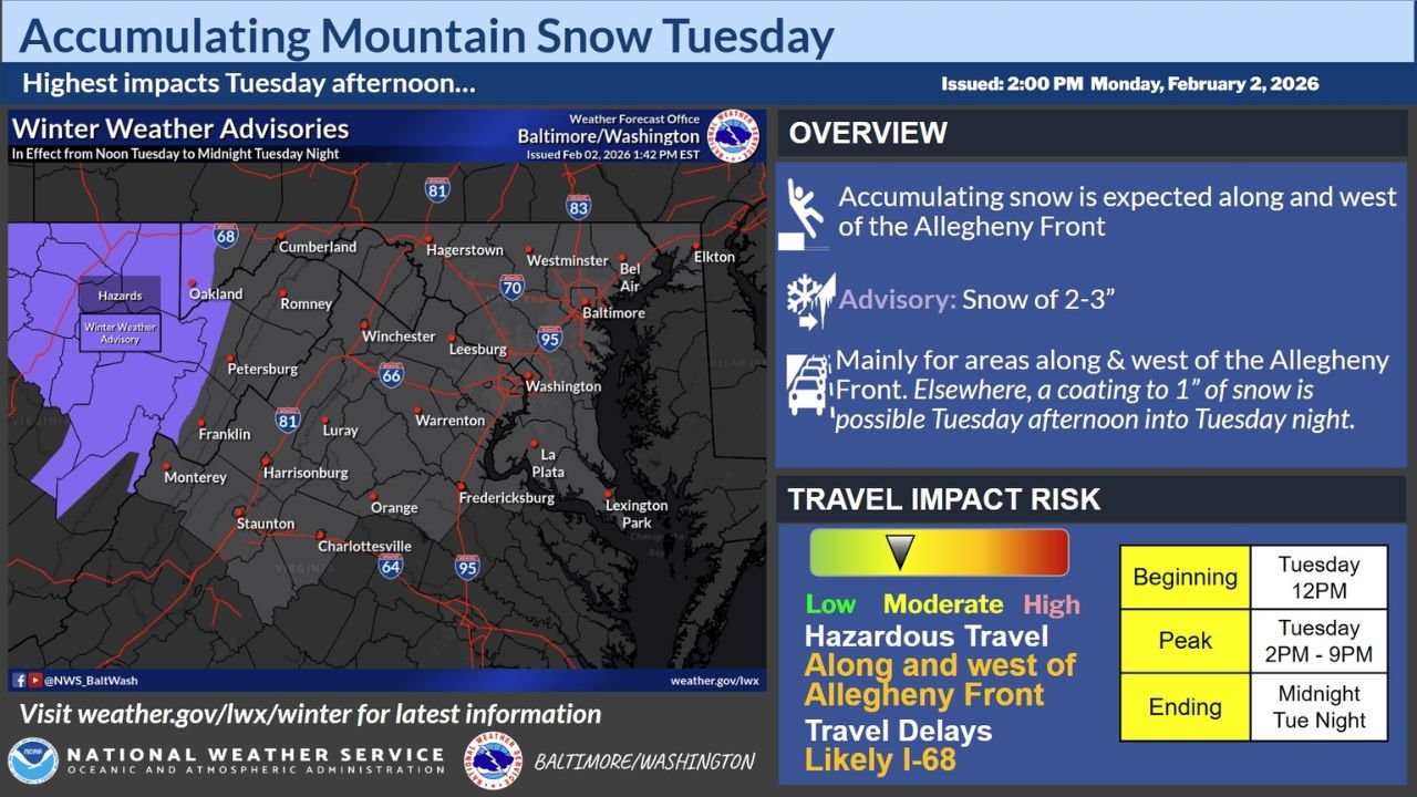
A Winter Weather Advisory is in effect from noon Tuesday through midnight Tuesday night, targeting higher-elevation communities where snow accumulation and travel disruptions are most likely.
Snow Expected Mainly Along and West of the Allegheny Front
Forecast guidance shows accumulating snow developing Tuesday afternoon, with the most persistent snowfall occurring along and west of the Allegheny Front. Locations within this zone are expected to receive 2 to 3 inches of snow by late Tuesday evening.
Communities included in the advisory area and highest-impact zone include Oakland, Cumberland, Romney, Petersburg, and surrounding mountain areas, where elevation will enhance snowfall rates.
Lighter Snow Possible Outside the Advisory Area
Outside of the mountainous advisory zone, snowfall amounts are expected to be lower. Forecast data indicates that a light coating up to 1 inch of snow is possible across portions of western and central Maryland, northern Virginia, and nearby low-elevation areas Tuesday afternoon into Tuesday night.
While accumulations will be lighter in these areas, cold temperatures may still allow snow to stick to untreated surfaces.
Travel Impacts Likely During Peak Evening Hours
The National Weather Service highlights a moderate risk for hazardous travel along and west of the Allegheny Front, especially on mountain roads and higher-elevation routes.
- Snow begins: around Tuesday noon
- Peak impacts: Tuesday 2 p.m. to 9 p.m.
- Snow tapers: by midnight Tuesday night
Travel delays are considered likely along Interstate 68, where snow-covered roads and reduced visibility may develop during the afternoon and evening hours.
Mountain Terrain Increases Hazard Risk
Forecasters emphasize that even moderate snowfall totals can have outsized impacts in mountain terrain, where temperatures remain cold enough for snow to accumulate quickly.
Drivers traveling through higher elevations Tuesday afternoon and evening should be prepared for changing road conditions, particularly during the evening commute window.
Advisory Focused on Short-Duration but High-Impact Event
This event is expected to be relatively brief, but its timing during the late afternoon and evening hours increases the potential for travel disruptions.
Residents and travelers in advisory areas are encouraged to monitor conditions and allow extra time if traveling through the mountains.
Stay with Waldronnews.com for continued updates on winter advisories, snowfall timing, and travel impacts across the Mid-Atlantic and Appalachian regions.