
Ohio, Indiana, and Pennsylvania Face 60–70 MPH Wind Gust Threat as Multiple Models Increase Late-Week Projections Across Columbus, Cleveland, Dayton, and Pittsburgh
OHIO — Forecast models are steadily increasing projected wind gusts for late Thursday night into Friday, with several major guidance packages now signaling widespread 55 to 70 mph gust potential across Ohio, eastern Indiana, and western Pennsylvania.
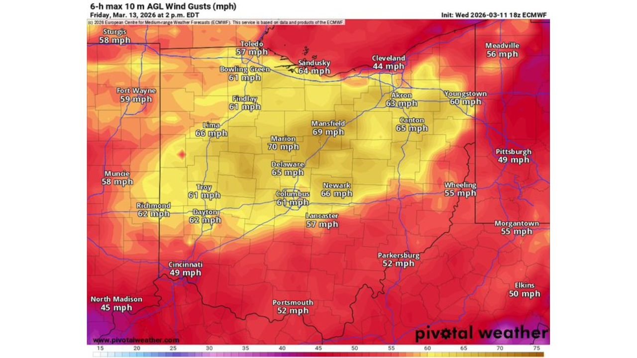
Updated high-resolution model data — including NAM 3km, HRRR, and ECMWF guidance — show an expanding corridor of intense surface wind gusts that could bring impactful conditions to major cities including Columbus, Cleveland, Toledo, Dayton, Akron, and Pittsburgh.
Widespread 55–65 MPH Gusts Across Central and Northern Ohio
Model projections for Friday morning and early afternoon indicate:
- Columbus: 57 to 61 mph
- Delaware: Up to 61 mph
- Mansfield: 62 to 70 mph (highest ECMWF projection)
- Akron: 58 to 63 mph
- Canton: Around 59 to 65 mph
- Cleveland: 59 to 65 mph
- Toledo: 57 to 60+ mph
- Lima & Findlay: Near 60 to 62 mph
The strongest cluster of projected gusts appears centered over north-central Ohio, where some guidance suggests isolated gusts approaching 70 mph — particularly near Mansfield and surrounding counties.
Dayton, Cincinnati, and Southwest Ohio Also Impacted
Southern and western Ohio are not spared in this setup:
- Dayton: 56 to 62 mph
- Troy: Near 58 to 61 mph
- Cincinnati: 54 to 55 mph
- Lancaster: Around 54 to 57 mph
These gust levels are strong enough to down tree limbs, cause scattered power outages, and make travel hazardous for high-profile vehicles.
Eastern Ohio and Western Pennsylvania in the Wind Corridor
As the system pushes east, elevated gusts continue across:
- Youngstown: 50 to 54 mph
- Wheeling: 41 to 55 mph
- Pittsburgh: 39 to 49 mph
- Parkersburg: 45 to 52 mph
While slightly lower than central Ohio projections, these gusts still fall within impactful wind advisory to high wind warning territory depending on final verification.
Model Consensus Increasing Confidence
What stands out is the consistency across multiple model runs:
- NAM 3km shows widespread upper 50s to low 60s mph
- HRRR reflects similar values across central Ohio
- ECMWF 6-hour max gust output indicates localized 65–70 mph potential
Forecasters often note that model wind gust projections can run slightly aggressive. However, even trimming these values down by 5 to 10 mph still leaves a substantial wind event across the region.
Timing and Impacts
The highest gust potential appears focused:
- Late Thursday night into early Friday
- Peak winds likely Friday morning into early afternoon
If these projections verify, residents could experience:
- Downed tree limbs
- Power outages
- Difficult driving conditions
- Possible minor structural damage
Areas north of Interstate 70 and especially along and north of U.S. Route 30 appear most favored for the strongest gusts.
A Potentially Significant Wind Event
While not necessarily a historic windstorm, the scale and consistency of 60+ mph projections across a broad portion of Ohio and adjacent states suggests this is more than a routine breezy day.
Residents across Ohio, Indiana, and western Pennsylvania should secure loose outdoor items and stay updated on potential wind advisories or high wind warnings as the event approaches.
Stay with WaldronNews.com for continued updates as this late-week wind event develops.