
Ohio Indiana Illinois Missouri and Michigan Residents Urged To Prepare As Overnight Severe Storm Threat Targets Ohio Valley And Great Lakes
OHIO VALLEY & GREAT LAKES — A renewed round of severe weather is expected to impact parts of Ohio, Indiana, Illinois, Missouri, and Michigan from Friday evening into early Saturday morning, with conditions supporting damaging winds, large hail, and a few tornadoes as storms organize and move east.
This evolving setup will bring two phases of storm activity, beginning with scattered afternoon storms before transitioning into a more organized and potentially impactful overnight system.
Isolated Storms Begin Developing This Afternoon
During the afternoon hours, isolated to scattered thunderstorms are expected to develop across the region, particularly in:
- Illinois
- Indiana
- Western Ohio
These early storms may remain somewhat limited in coverage but could still produce:
- Localized strong wind gusts
- Large hail in stronger cells
- Brief heavy downpours
Stronger Line Of Storms Expected Late Tonight
The more significant concern arrives later, as a line of storms develops and pushes eastward overnight into Saturday morning.
This system is expected to track through:
- Missouri into Illinois
- Across Indiana
- Into Ohio and parts of Michigan
As storms organize into a line, the risk will shift toward:
- Widespread damaging wind gusts
- Embedded areas of large hail
- Isolated tornado potential, especially within stronger segments
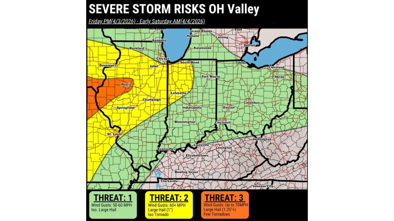
Highest Risk Zone Centered Over Illinois Into Missouri
The most intense severe threat is currently focused across:
- Central and western Illinois (including Peoria and nearby areas)
- Eastern Missouri including St. Louis region
In this corridor:
- Wind gusts could reach up to 70 mph
- Large hail exceeding 1.25 inches is possible
- A few tornadoes cannot be ruled out
Moderate Risk Expands Across Indiana And Parts Of Illinois
A broader zone of concern stretches into:
- Eastern Illinois
- Much of Indiana including Indianapolis
- Parts of northwestern Ohio
Here, storms may produce:
- Wind gusts over 60 mph
- Hail around 1 inch in diameter
- An isolated tornado risk
Lower But Notable Risk Across Ohio And Michigan
Further east into:
- Ohio including Columbus, Dayton, and Cincinnati
- Southern Michigan including areas near Detroit
The risk lowers slightly but still includes:
- Wind gusts between 50–60 mph
- Isolated large hail
- Occasional strong storms within the line
Timing Breakdown Across The Region
- Afternoon: Isolated storms begin developing
- Evening: Storm coverage increases across Illinois and Missouri
- Late Night: Organized line pushes through Indiana
- Early Morning Saturday: Storms reach Ohio and Michigan
Residents Should Stay Alert Through Overnight Hours
Because much of this event unfolds overnight, the risk becomes more dangerous due to reduced visibility and response time.
Residents are advised to:
- Keep weather alerts enabled on mobile devices
- Have a safe shelter plan ready before nighttime
- Stay updated as storms evolve rapidly through the evening
Multi-State Overnight Storm Threat Demands Attention
This setup represents a classic overnight severe weather scenario across the Ohio Valley and Great Lakes, where storms may intensify quickly and impact multiple states in succession.
Stay with WaldronNews.com for continuous updates, storm tracking, and critical warnings as this overnight severe weather threat unfolds across the region.