
Ohio, Kentucky, Indiana Face Overnight Severe Storm Threat With Isolated Tornado Risk From Cincinnati to Columbus Late Thursday
OHIO — A potentially dangerous round of severe weather is expected to sweep across the Ohio Valley late Thursday night, bringing the risk of damaging winds, large hail, isolated tornadoes, and localized flooding as a cold front pushes through the region.
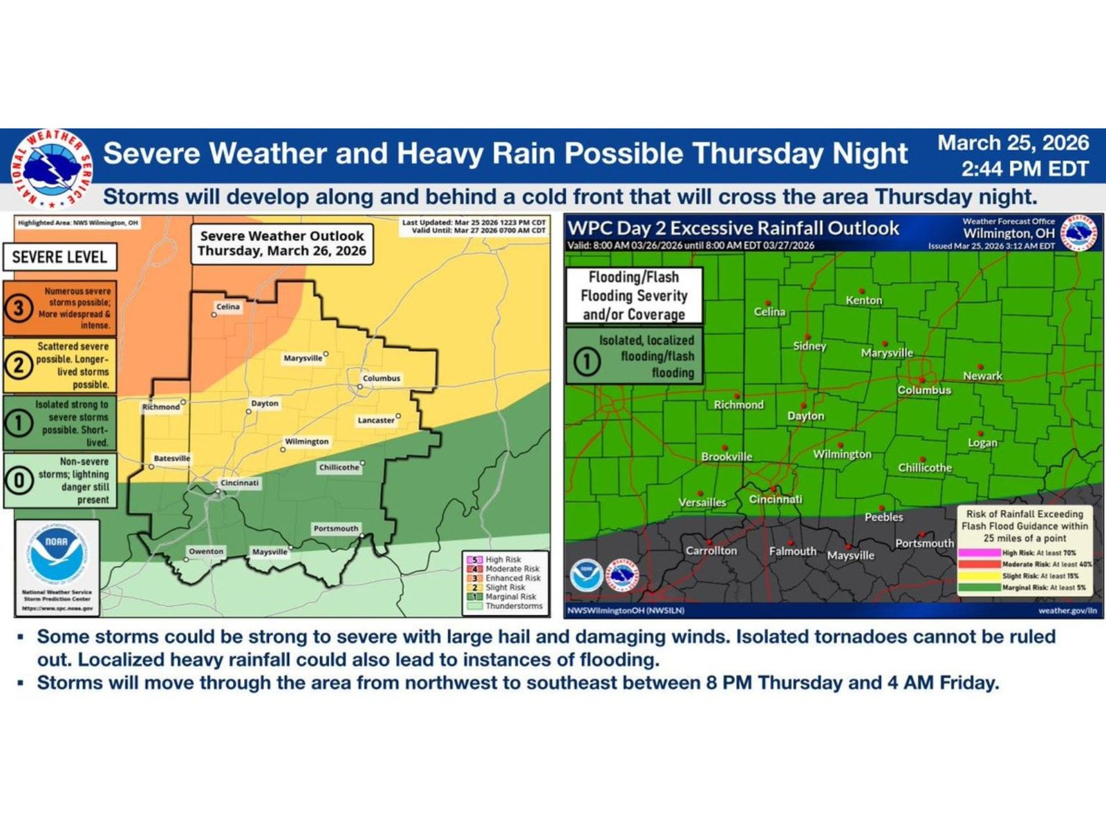
Forecast data highlights southern Ohio and northern Kentucky as the primary zone of concern, with cities including Cincinnati, Wilmington, Chillicothe, Portsmouth, and surrounding communities facing the highest likelihood of severe impacts overnight.
Enhanced Risk Targets Southern Ohio and Northern Kentucky
The most intense storms are expected to develop within an Enhanced Risk area, covering much of southern Ohio and extending into northern Kentucky. This zone carries the greatest confidence for severe thunderstorms capable of producing widespread impacts.
Areas slightly farther north, including Dayton, Columbus, and Newark, fall under a Slight Risk, where severe storms are still possible but expected to be less intense or more isolated.
Forecasters emphasize that storms developing along and behind the advancing cold front will have the potential to quickly strengthen as they move across the region.
Timing: Dangerous Window Late Thursday Night Into Early Friday
The timing of this system is particularly concerning due to its overnight arrival.
- Main severe window: 9 PM Thursday to 2 AM Friday
- Storms expected to move northwest to southeast between roughly 8 PM and 4 AM
- Threat gradually weakens as the night progresses into early Friday morning
This overnight timing increases the risk, as many residents may be asleep when warnings are issued.
Hazards Include Damaging Winds, Hail, and Isolated Tornadoes
Storms are expected to be capable of producing:
- Damaging wind gusts, potentially leading to downed trees and power outages
- Large hail, especially within stronger storm cores
- Isolated tornadoes, particularly within the Enhanced Risk zone
- Heavy rainfall, which could trigger localized flooding or flash flooding
While tornado risk is described as isolated, it cannot be ruled out, especially in southern sections of Ohio and nearby Kentucky counties.
Flooding Risk Present Across the Region
In addition to severe storms, the region is also under a low-end (Level 1) risk for excessive rainfall, meaning isolated flooding is possible.
Localized heavy downpours could lead to water accumulation in low-lying areas, poor drainage zones, and along small creeks or streams.
Storm Progression and Impact Areas
The system is expected to enter western portions of the region Thursday evening before pushing eastward overnight:
- Early impacts near Indiana and western Ohio (including areas near Richmond and Dayton)
- Strongest storms tracking through Cincinnati, Wilmington, and Chillicothe corridor
- Continued eastward movement toward Portsmouth and southeastern Ohio overnight
Northern areas such as Celina, Kenton, and Sidney may see storms arrive earlier in the evening, but with comparatively lower severe intensity.
What Residents Should Do Now
With a nighttime severe weather event expected, preparation is critical:
- Ensure weather alerts are enabled on mobile devices
- Identify a safe place in your home for severe weather warnings
- Stay updated on forecast changes as timing and intensity become clearer
Residents should be especially alert Thursday night as conditions could change rapidly.
Waldron News will continue monitoring this developing severe weather situation and provide updates as new information becomes available.