
Ohio River Valley Snowstorm Rapidly Intensifies as Heavy Bands Set Up Across Southern Indiana, Ohio, and Northern Kentucky
SOUTHERN INDIANA — A rapidly intensifying winter storm is now locking into place across the Ohio River Valley, with heavier snow bands strengthening late tonight from southern Indiana into Ohio and northern Kentucky as the system enters a more dynamic phase.
As of 9:07 p.m. EST, 0.6 inches of snow had already been measured north of Greensburg, Indiana, and radar trends indicate snowfall rates will increase significantly overnight as persistent banding develops along and just north of the Ohio River.
Why Snowfall Is Accelerating in This Corridor
Analysis of satellite imagery and high-resolution model guidance shows:
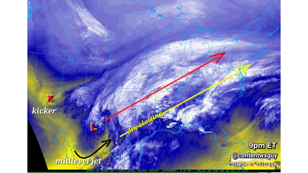
- A deepening surface low tracking east of the Mississippi Valley
- A strengthening mid-level jet enhancing lift over Indiana and Ohio
- Increasing frontogenesis, which is tightening snow bands and boosting rates
While a mid-level dry slot is visible upstream, it is arriving too late to meaningfully cut totals in the hardest-hit areas. By the time dry air noses in, several hours of heavy snow will already be on the ground, with additional snow wrapping in behind the system.
Heaviest Snow Focus: Ohio River Northward
The most consistent signal for heavy accumulation is focused on:
- Southern Indiana (including areas near Greensburg and north of the Ohio River)
- Central and southern Ohio
- Northern Kentucky near the river corridor
Model guidance supports 8–14 inches of snowfall, with locally higher totals possible where mesoscale bands stall for multiple hours. Areas farther south may see some mixing at times, while locations north of the core band could see lower—but still impactful—totals.
Overnight Impacts Expected
- Snowfall rates increasing after midnight
- Rapid road deterioration, especially secondary roads
- Reduced visibility under heavier bands
- Difficult morning travel likely in banded snow zones
Bottom Line
This system is strengthening, not weakening. Atmospheric dynamics are aligning over the Ohio River Valley, setting the stage for significant snowfall across southern Indiana, Ohio, and northern Kentucky before the storm pulls east.
Stay with us for live snow reports, accumulation updates, and overnight impact tracking. If you’re in southern Indiana, Ohio, or northern Kentucky and seeing heavy snow, share your totals — real observations matter as this storm evolves.