
Ohio, West Virginia, Pennsylvania, Maryland and Virginia Under Marginal Severe Storm Risk as Cold Front Triggers Hail and Damaging Wind Threat Across the Mid-Upper Ohio Valley
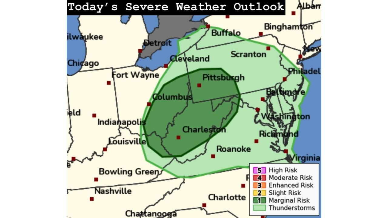
UNITED STATES — The Storm Prediction Center (SPC) has maintained a Marginal Risk (Level 1 of 5) for severe weather across portions of the mid and upper Ohio Valley, placing parts of Ohio, West Virginia, Pennsylvania, Maryland, and Virginia under the potential for isolated strong storms later today.
While this is not a widespread severe outbreak, forecasters warn that a few storms could briefly turn strong as a cold front moves through the region this afternoon and evening.
Risk Zone Covers Columbus, Pittsburgh and Charleston
The highlighted risk area includes:
- Columbus, Ohio
- Pittsburgh, Pennsylvania
- Charleston, West Virginia
- Portions of western Maryland
- Northern and western Virginia
- Far western Pennsylvania near Cleveland
The darker green shading indicates the core Marginal Risk zone, while the lighter green area outlines general thunderstorm potential extending into parts of western New York and the Mid-Atlantic.
What’s Driving Today’s Storm Threat
According to the outlook, cool temperatures aloft combined with modest low-level moisture are expected to create enough instability for scattered thunderstorms to develop along an advancing cold front.
However, forecasters emphasize that moisture levels are limited, which will help prevent a more significant severe event.
Still, a few storms could briefly intensify.
Primary Hazards: Hail and Damaging Winds
Even within a Marginal Risk, impacts are possible. The main threats include:
- Isolated large hail
- Localized damaging wind gusts
- A very low but non-zero brief tornado risk
Low-topped storms — which are common in cooler-season setups — can sometimes produce quick bursts of severe weather despite lacking classic summer instability profiles.
Communities from Columbus to Pittsburgh and southward into Charleston should remain weather-aware through the late afternoon and early evening hours.
Why the Risk Remains Limited
Several factors are keeping the overall threat lower-end:
- Meager moisture return
- Limited instability compared to springtime severe setups
- Lack of strong surface heating in some areas
As a result, storms are expected to remain scattered rather than widespread.
Timing and What to Expect
Storm development is most likely during the afternoon into early evening, tracking eastward along the cold front. Activity should gradually diminish after sunset as instability decreases.
While the majority of residents will experience nothing more than brief downpours and gusty winds, isolated pockets could see stronger impacts.
Stay Weather Aware
Even marginal setups can produce isolated severe weather, especially in March when atmospheric dynamics can compensate for limited moisture.
Residents across Ohio, West Virginia, Pennsylvania, Maryland, and Virginia are encouraged to monitor local forecasts and have a way to receive weather alerts if storms intensify quickly.
Stay with WaldronNews.com for continued updates on today’s developing weather situation across the Ohio Valley and Mid-Atlantic.