
Oklahoma Faces Potentially Historic Cold as New NOAA Forecast Shows Unprecedented Pressure Patterns Developing Before Christmas
OKLAHOMA — New long-range data from NOAA’s flagship GFS model is raising alarms across the meteorological community, with multiple forecast cycles now projecting a severe, potentially historic blast of Arctic air that could plunge Oklahoma and much of the central United States into extreme cold heading into Christmas week. The model suggests that the polar vortex may undergo significant stretching — a pattern that often precedes major cold outbreaks — with surface pressure anomalies that forecasters say would be “unprecedented in the 21st century” if they were to materialize.
NOAA Model Shows Aggressive Polar Vortex Disruption
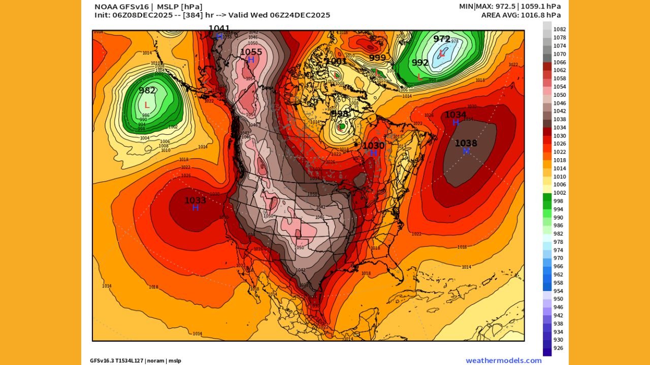
The latest NOAA GFS runs display a dramatic elongation of the polar vortex by December 24, illustrating how repeated atmospheric “pulling” on the vortex can eventually force frigid Arctic air southward. Meteorologists warn that if this distortion continues, the containment of cold air in the far north could fail, unleashing a widespread freeze across the Plains and lower Midwest — including Oklahoma.
Pressure maps for Christmas week reveal unusually deep low-pressure zones over Canada and intense high-pressure ridges over the Pacific and Atlantic. This configuration funnels cold air directly into the central U.S., a setup that forecasters rarely see at this magnitude.
Experts emphasize that while long-range models can fluctuate, the consistency of this extreme signal over several cycles raises concern. The model’s depiction of widespread dark gray pressure anomalies — indicating drastically colder surface temperatures — covers nearly all of Oklahoma.
Oklahoma Could See Dangerous Wind Chills if Pattern Holds
Under the projected pattern, Oklahoma would sit squarely underneath a powerful Arctic dome. Temperatures could plunge well below normal, with the potential for dangerous wind chills, icy travel conditions, and stress on vulnerable populations.
Even without a major storm system, the cold alone could become a risk factor. Historically, early-season Arctic outbreaks of this magnitude strain infrastructure, livestock operations, and energy grids. State officials often monitor long-range NOAA projections very closely for this reason, especially when strong Arctic air is involved.
Forecasters caution that no specific temperature values should be taken literally at this range, but the pressure pattern itself — not the exact numbers — is the historic element. If the modeled high-latitude blocking verifies, Oklahoma will feel direct downstream impacts.
What Makes This Forecast “Unprecedented”
Meteorologists cite several highly unusual model features:
- Surface pressure anomalies over North America reaching levels rarely seen in the modern record.
- A deeply stretched polar vortex, resembling disruptions associated with major cold outbreaks from previous decades.
- A persistent signal across multiple GFS runs, which reduces the likelihood of random model noise.
- Synchronized high-pressure ridging over the Pacific and Atlantic, a configuration that can lock Arctic air in place for extended periods.
These combined factors suggest that, while not guaranteed, the potential for a historic December cold wave is higher than normal.
Model Uncertainty Still Exists — But the Risks Are Real
Long-range projections always come with uncertainty, and experts stress that atmospheric patterns can shift significantly over 10–16 days. A single adjustment in the jet stream could soften or even prevent a major cold outbreak.
However, forecasters note that the trend, not the day-to-day run, is what stands out. The GFS has repeatedly shown the same broad setup: stretching of the polar vortex, downstream ridge-trough alignment, and deep cold spilling into the Plains.
Even if the final outcome is milder than depicted, Oklahoma residents should prepare for the realistic possibility of a significantly colder-than-normal Christmas stretch.
Stay with WaldronNews.com for continuing updates as forecasters refine the data and a clearer picture emerges closer to Christmas.