
Oklahoma, Kansas, Missouri, Iowa and North Texas Brace for Dangerous Storm Setup as EF2+ Tornado Potential Emerges Friday Evening
OKLAHOMA — A volatile weather pattern developing across the Plains and Mississippi Valley is expected to trigger widespread severe storms Friday, with conditions supporting large hail, damaging winds, and the possibility of strong tornadoes across several states, including Oklahoma, Kansas, Missouri, Iowa, and parts of North Texas.
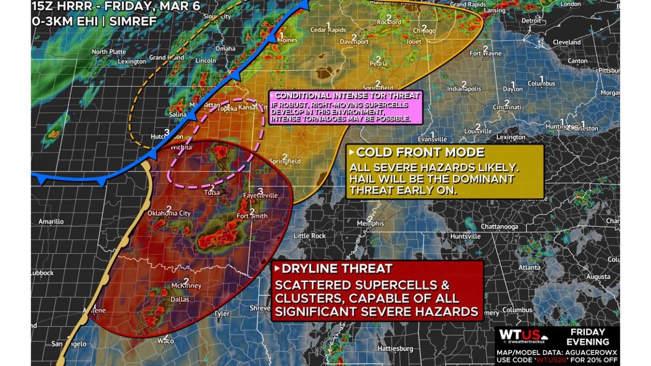
Forecast discussions highlight two primary storm development zones — one along an advancing cold front stretching from Kansas into Iowa, and another along the dryline positioned across western Oklahoma and North Texas, where the most dangerous storms could develop later in the day.
Together, these two weather boundaries are creating a powerful environment capable of producing multiple severe weather hazards across a large portion of the central United States.
Cold Front Storms Could Expand Across Kansas, Missouri and Iowa
Storms are expected to begin developing along the cold front during the afternoon as it pushes eastward through the Plains. Early storms forming along this boundary may initially produce large hail, particularly where storms develop within cooler air near the frontal boundary.
As the afternoon progresses into evening, storms forming along or just ahead of the cold front are expected to strengthen and could begin producing a broader range of severe hazards.
The most active corridor along the cold front is projected to extend from northeast Kansas through northwest Missouri and into central Iowa, placing several communities in the path of intensifying thunderstorms.
Cities potentially affected within this zone include:
- Topeka, Kansas
- Kansas City, Missouri
- Des Moines, Iowa
Storms in this region may gradually organize into a large line of thunderstorms after sunset, a structure known as a quasi-linear convective system. When storms organize in this way, they can produce widespread damaging winds and embedded tornadoes as they move rapidly across the Midwest overnight.
Dryline Storm Development Targets Oklahoma and North Texas
Farther south, the most concerning environment for intense severe weather appears to be developing along the dryline stretching through western Oklahoma and into North Texas.
This region is expected to support isolated but powerful thunderstorms capable of producing all types of severe weather, including very large hail, damaging wind gusts, and strong tornadoes.
The most favorable area for storm development lies east of the dryline, where warm, moisture-rich air from the Gulf of Mexico combines with strong atmospheric wind shear.
Cities that could be impacted within this storm zone include:
- Oklahoma City, Oklahoma
- Tulsa, Oklahoma
- Dallas–Fort Worth, Texas
- Wichita Falls, Texas
Storm development across eastern Oklahoma during the evening may become somewhat messy as storms interact with each other, but any storm that remains organized could become capable of producing significant tornadoes rated EF2 or stronger.
Northern Oklahoma, Eastern Kansas and Western Missouri Under Conditional Tornado Risk
Another corridor of concern stretches from northern Oklahoma through eastern Kansas into western Missouri, where conditions are supportive of severe storms but where storm development remains somewhat uncertain.
In this region, storms may form later in the evening if enough daytime heating remains to destabilize the atmosphere.
If storms do develop here, the environment could support intense supercell thunderstorms capable of producing large hail and strong tornadoes. Tornadoes in this area may form quickly and follow unusual paths as storms interact with shifting winds in the atmosphere.
Because storm formation in this corridor is less certain, the tornado threat here is considered conditional, but the environment itself remains capable of supporting significant severe weather if storms develop.
Evening Storm Mode Could Become More Organized
As the evening progresses, scattered storms across the Plains are expected to gradually merge into larger clusters and lines of storms.
This transition may increase the risk of widespread damaging wind events across parts of the Midwest, particularly from Kansas and Missouri into Iowa overnight.
Even as storms organize into larger lines, the possibility of embedded tornadoes within the storm line remains, especially where the strongest wind shear is present.
Large Multi-State Severe Weather Event Possible
The combination of a strong cold front, a sharpening dryline, and abundant moisture moving northward from the Gulf of Mexico is creating a classic severe weather setup across the central United States.
Multiple states could experience significant storm activity throughout the day and evening, including:
- Texas
- Oklahoma
- Kansas
- Missouri
- Iowa
With several different storm modes possible — including isolated supercells and organized storm lines — communities across these regions could see rapidly changing weather conditions.
Residents Across the Region Urged to Stay Alert
Severe storms capable of producing tornadoes and damaging winds can develop quickly when atmospheric conditions align as they are expected to during this event.
Residents across the Plains and Midwest are encouraged to stay alert for severe weather alerts and be prepared to take action if warnings are issued.
Storm timing, intensity, and exact locations may continue to evolve throughout the day as storms begin forming.
Stay with WaldronNews for continuing updates as this developing severe weather threat unfolds across the Plains and Midwest.