
Oklahoma, Texas and Kansas Face Dangerous Tornado Setup Today as Forecasters Warn Strong EF2+ Twisters, Giant Hail and 85+ MPH Winds Possible
SOUTHERN PLAINS, UNITED STATES — A volatile severe weather setup is expected to unfold across the Southern Plains today, with forecasters warning that parts of Texas, Oklahoma, and Kansas could see tornado-producing supercells capable of generating strong tornadoes, destructive winds, and large hail. The most concerning corridor stretches from northwest Texas through western and central Oklahoma into southern Kansas, where atmospheric conditions appear most favorable for dangerous thunderstorms.
Weather analysis indicates that storms developing across this region could become isolated supercells, which are the type of storms most capable of producing tornadoes and other significant severe weather hazards.
Tornado Threat Centered from Texas Panhandle to Central Oklahoma
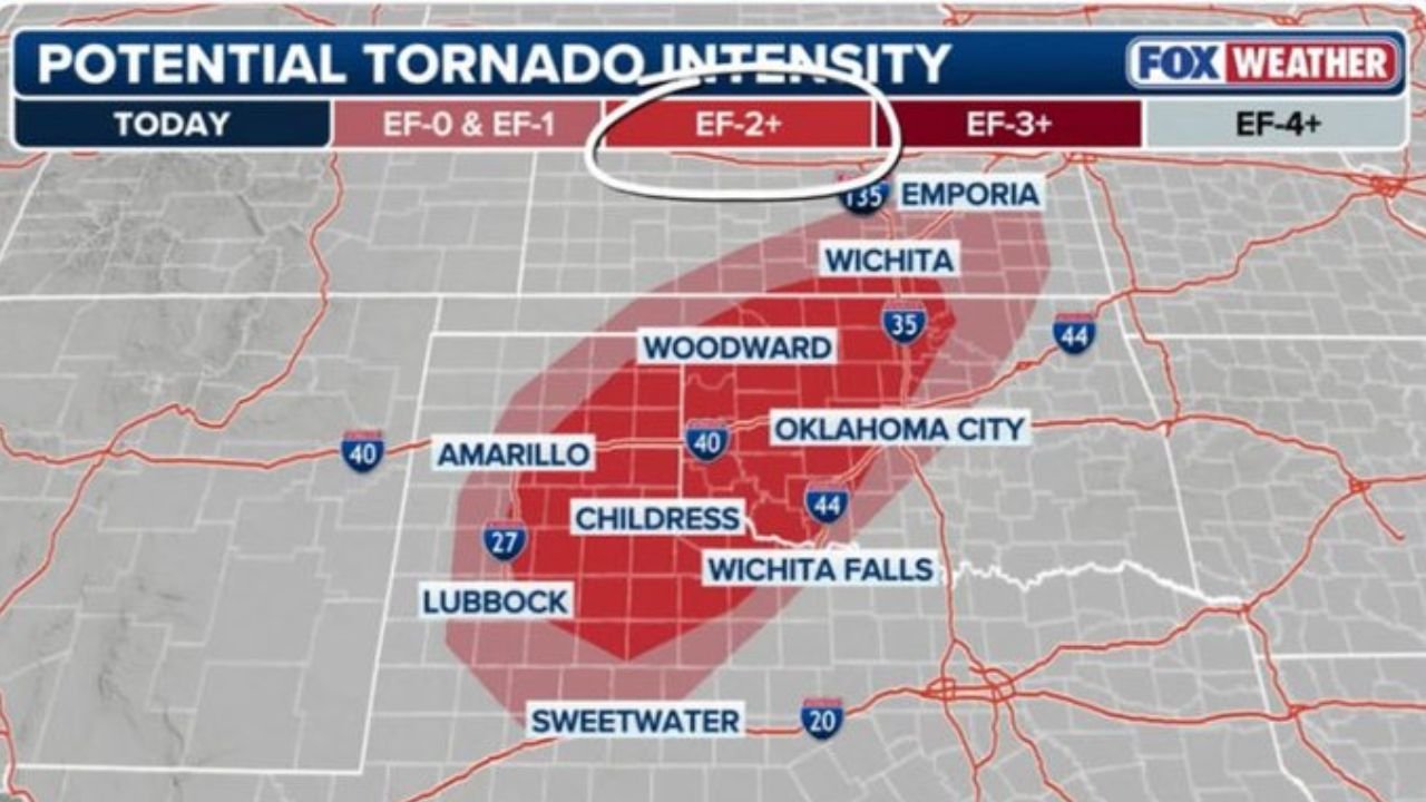
Forecast maps highlight a focused tornado threat zone extending from the Texas Panhandle through western Oklahoma and into southern Kansas.
Cities including Amarillo, Childress, Wichita Falls, Woodward, and Oklahoma City lie within the area where tornado development is possible as storms intensify.
Meteorologists say storms forming along a boundary across the region may quickly rotate due to strong wind shear in the atmosphere. If supercells remain isolated, they could produce tornadoes capable of causing significant damage.
Forecast guidance suggests some storms may even have the potential to produce strong tornadoes rated EF2 or higher, particularly in areas where storm rotation becomes well established.
Strong Tornadoes Could Develop in Most Intense Storms
The corridor from northwest Texas into western Oklahoma appears most favorable for stronger tornado development.
In this zone, the combination of instability, wind shear, and favorable storm structure could support tornadoes stronger than the typical weak EF0 or EF1 storms often seen in marginal setups.
Meteorologists emphasize that not every storm will produce a tornado, but any storm that becomes a sustained supercell could quickly intensify.
Communities in Amarillo, Woodward, and surrounding areas of the Texas and Oklahoma Panhandles should remain particularly alert for rapidly developing storms.
Damaging Winds Could Exceed 85 MPH
In addition to tornado risks, strong thunderstorms may also produce intense straight-line wind gusts, especially as storms merge into clusters later in the event.
Forecast projections indicate wind gust potential ranging from 60 mph to possibly over 85 mph in the strongest storms.
Areas including Wichita, Kansas City, Oklahoma City, and surrounding regions may experience severe wind bursts capable of knocking down trees and power lines.
These winds can sometimes produce damage similar to weaker tornadoes when embedded within organized storm systems.
Large Hail Possible Across the Central Plains
Another significant threat will be large hail, especially in storms forming early before they merge into lines.
Forecast guidance indicates a corridor from Midland and Lubbock in Texas through Amarillo, Oklahoma City, Wichita, and into Kansas where storms could produce hailstones larger than two inches in diameter.
In the strongest supercells, hail could approach golf-ball to egg size, capable of damaging vehicles, roofs, and crops.
The presence of cold air aloft and strong storm updrafts will help support these larger hail sizes.
Storms Expected to Develop During the Afternoon and Evening
Forecasters expect storms to begin forming during the afternoon across the Texas Panhandle and western Oklahoma, before spreading northeast toward Kansas and Missouri later in the evening.
The most intense storms are likely to occur during the late afternoon and evening hours, when atmospheric energy peaks.
Residents across the Southern Plains are encouraged to stay alert for weather warnings and rapidly changing conditions throughout the day.
Residents Urged to Monitor Severe Weather Alerts
Because supercell storms can intensify quickly, officials recommend that people in the affected region:
- Monitor weather alerts throughout the afternoon and evening
- Have a reliable way to receive tornado warnings
- Identify a safe shelter location in case severe storms approach
Severe weather outbreaks in the Plains can evolve rapidly, and storms capable of producing tornadoes, damaging winds, and large hail may impact multiple states throughout the day.
Stay with WaldronNews for continuing updates as this severe weather threat develops across Texas, Oklahoma, and Kansas.