
Oregon and Idaho Snowpack Shows Sharp Divide as Low Elevations Lag Far Below Normal While Mountain Snow Holds Near Average
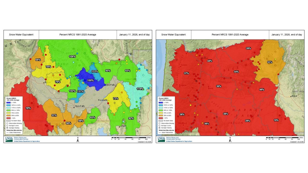
UNITED STATES — New snowpack data shows a stark contrast developing across the western U.S. as the region heads into a prolonged stretch of dry weather. A warm and wet start to winter has left low- and mid-elevation snowpack well below normal, while higher elevations above roughly 6,000 to 7,000 feet are holding near or even above average snow levels.
The imbalance highlights how early-season rain events, rather than snow, dramatically reshaped winter water storage across much of the West.
Low Elevations Struggle After Rain-Dominated Start
Across many lower-elevation basins, precipitation that would normally build snowpack instead fell as rain during the first half of winter. As a result:
- Large portions of Oregon and southwest Idaho are showing snowpack between 20% and 50% of normal
- Valley and foothill watersheds remain critically underperforming
- Snow water equivalent values in some basins are less than half of what is typical for mid-January
Much of western Oregon is now deeply shaded in red on snowpack maps, indicating persistent deficits heading into what is typically the heart of accumulation season.
Mountains Tell a Very Different Story
While lower elevations struggle, higher terrain has fared significantly better:
- Portions of central and eastern Idaho show snowpack at 100% to 150% of normal
- Several high-elevation watersheds are now above average, thanks to colder temperatures at altitude
- Mountain snowpack remains healthy where precipitation fell primarily as snow instead of rain
This elevation-dependent split underscores how temperature profiles, not just storm frequency, are shaping winter outcomes.
Why the Pattern Matters Heading Into a Dry Stretch
Forecasts suggest the region is entering a longer dry period, meaning existing snowpack will become increasingly important. When storms pause:
- Low-elevation deficits tend to worsen, as melting continues without replenishment
- High-elevation snowpack becomes the primary water reserve for spring runoff
- Rivers, reservoirs, and irrigation systems become more reliant on mountain snow
If dry conditions persist, the current imbalance could have long-term implications for water supply, particularly in basins that depend on lower-elevation snowmelt.
Water Supply and Spring Outlook Concerns
The uneven snowpack raises several concerns moving forward:
- Earlier runoff timing if remaining snow melts faster at lower elevations
- Reduced spring streamflow in basins lacking strong mountain snow
- Increased pressure on reservoir storage and water management decisions
While it is still early enough in winter for recovery in some areas, continued warmth or lack of storms would lock in these deficits.
What to Watch Next
Key factors that will determine whether conditions improve include:
- Whether colder storms return to allow snow at lower elevations
- The duration of the upcoming dry pattern
- Late-season storm activity in February and March
For now, high mountain snowpack is carrying the load, while valleys remain vulnerable.
Bottom Line
The western U.S. snowpack entering mid-January reflects a winter of extremes — healthy to surplus snow in higher elevations, but deeply deficient snowpack across lower terrain after a rain-heavy start to the season. As dry weather sets in, this divide becomes increasingly important for spring water supply, wildfire risk, and long-term drought outlooks.
Stay with Waldron News for continued snowpack updates, drought monitoring, and western weather impacts as winter evolves.